Estimated read time: 3-4 minutes
This archived news story is available only for your personal, non-commercial use. Information in the story may be outdated or superseded by additional information. Reading or replaying the story in its archived form does not constitute a republication of the story.
SALT LAKE CITY — Utah's 2022 water year precipitation roller coaster took a bit of a tumble again in January.
Last month was Utah's third-driest January dating back to 1895, the National Centers for Environmental Information reported Tuesday. Only 1919 and 1961 produced drier Januarys on record.
Last month also followed what was the seventh-wettest December. In fact, the first four months of the 2022 water year, which began on Oct. 1, have alternated extremes. October 2021 was the 16th wettest October since 1895, while November 2021 was the ninth-driest before the wet December and dry January.
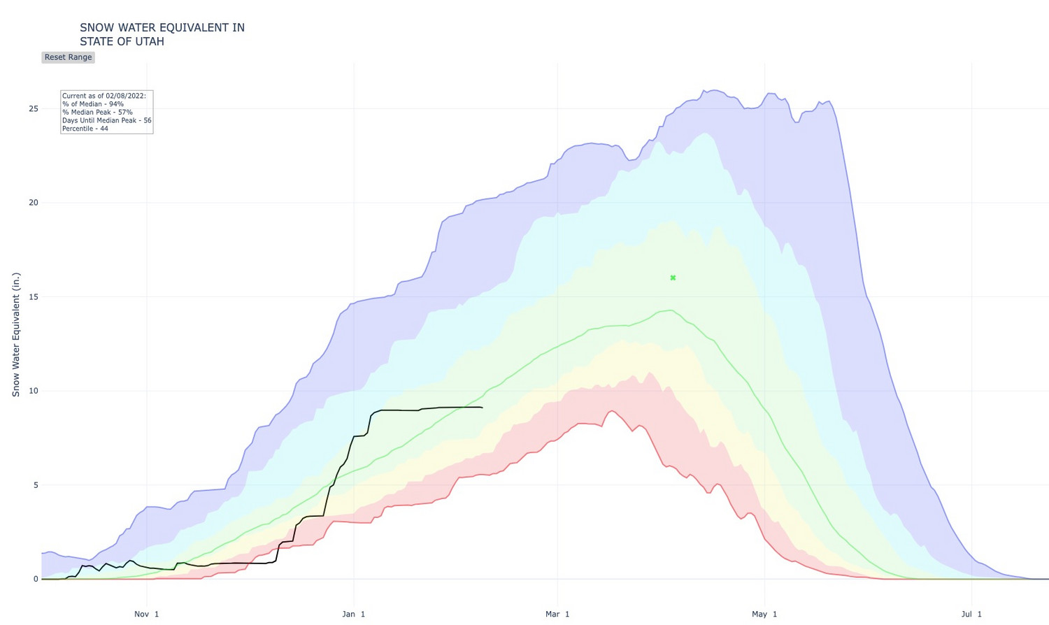
These extremes have left Utah with a slightly-below average snowpack for the second week of February but in better shape than the same time a year ago.
Utah's snowpack, which has only increased by 0.1 inches since Jan. 9, remains at 9.1 inches, according to the Natural Resources Conservation Service. That's now 94% of the normal for Feb. 8. It entered 2022 at about 126% of normal, and it dropped to 100% at the beginning of this month. However, Utah's snowpack didn't reach 9.1 inches until Feb. 17 last season.
Some snowpacks are doing better than others. The Beaver River snowpack region, for instance, remains at 123% while the Tooele Valley-Vernon Creek snowpack has dropped to 69%. The Wasatch Front basins range between 85% and 95% of normal for this time of the year.
The statewide drought situation is better than it was ahead of the 2022 water year. The U.S. Drought Monitor reports that Utah entered February with nearly one-third of the state in "extreme" drought status and 93.8% dealing with at least "severe" drought conditions. About 14% of the state was listed in "exceptional" drought while 78% was listed in at least "extreme" drought status three months ago.
Utah also wasn't alone in dealing with an abnormally dry start to the 2022 calendar year. California and Nevada each ended up with their second-driest Januarys on record, while all the remaining Western states, aside from Washington, received below-normal precipitation. Washington, benefitting from La Nina weather patterns, ended up with slightly above-normal precipitation totals.
"Precipitation was below average across most of the lower 48. Regions with below-average precipitation included much of the West, High Plains, Deep South, Great Lakes and Northeast," the National Centers for Environmental Information wrote in its January 2022 report.
The good news is that Utah's roller coaster might be going up again by the end of the month, meaning that much-needed snow could return to Utah soon.
The National Weather Service's Climate Prediction Center still projects generally dry conditions to dominate the short-term future. This is why inversion conditions are expected throughout this week. KSL meteorologist Kevin Eubank added the current weather models indicate a possible storm arriving Wednesday, but the storm models only show some snow flurries out of it and the cold front likely won't be strong enough to break the inversion.
Yet northern Utah has a stronger probability for wetter than normal conditions in the period between Feb. 19 and March 4. The rest of the state is listed in "equal chances," which means there aren't any signals as to wetter or drier conditions in that span, according to the center.
👀 Is there a light at the end of this long and dry tunnel? Cluster analysis of 3 ensemble forecast systems we use indicates the majority of the ensemble members are showing some sort of trough over the West by 2/15 We'll keep you posted on the trends as it gets closer. #utwxpic.twitter.com/61clGRMzbL
— NWS Salt Lake City (@NWSSaltLakeCity) February 8, 2022
"(The) long-range guidance is indicating the potential for us to see a more progressive pattern next week, which would lead to cooler and wetter conditions," the weather service's Salt Lake City office tweeted Tuesday. "We are cautiously optimistic."
While most of the state was projected for drier conditions in January and February, most of northern Utah is now in "equal chances" for the combination of February, March and April. That gives even additional optimism for a wet start to meteorological spring, which starts on March 1.
As for the near future, full seven-day forecasts for areas across Utah can be found at the KSL Weather Center.