- Utah experienced its hottest summer on record with an average temperature of 73.7 degrees.
- Despite increased rainfall, Utah's water availability remains affected by record-low snowpack.
- Monsoonal rains benefited mountain areas, but some soil moisture levels remain below normal.
SALT LAKE CITY — If this past summer felt warmer than usual in Utah, it was.
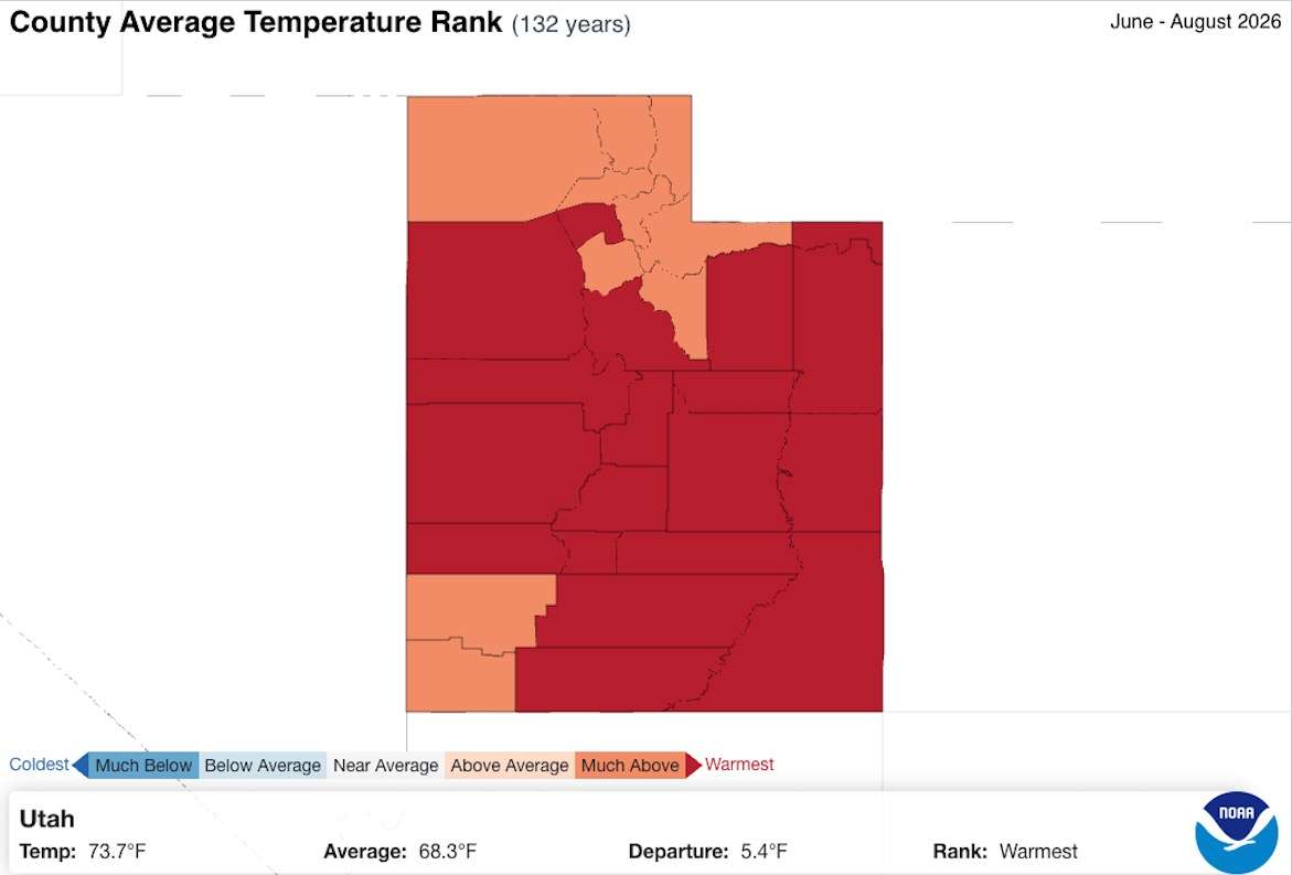
The state's average temperature this past meteorological summer — June through August — was 73.7 degrees, 0.7 degrees above the previous record set in 2021, according to new data released by the National Centers for Environmental Information on Wednesday. The agency's database goes back to 1895.
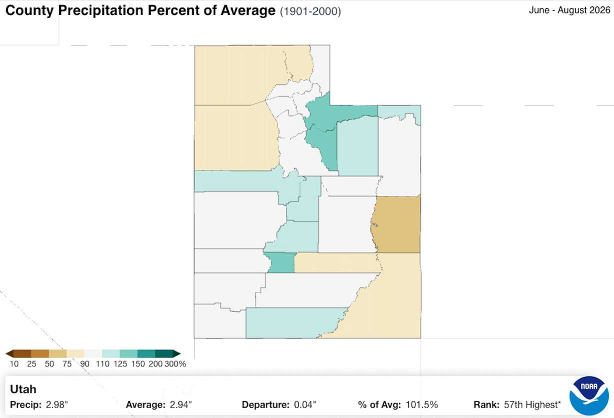
Utah also collected, on average, 2.98 inches of precipitation over the summer, nearly double last summer's production and its 57th wettest over the past 132 years.
However, federal hydrologists say it wasn't enough to overcome the effects of this year's record-low snowpack.
"Utah's overall water availability is continuing to feel the adverse impacts from our record-poor snowpack season last winter," Jordan Clayton, a hydrologist for the Natural Resources Conservation Service, wrote in a report summarizing the state's hydrology at the end of meteorological summer published earlier this week.
Record summer heat
Utah's summer record follows a trend over the past year. The state posted its warmest winter and second-warmest spring this year. Fall 2025 also set a record before this year's run.
The new record also wasn't all too surprising, following some other localized records throughout the season. For example, Salt Lake City broke its all-time high temperature record in July, when the temperature reached 109 degrees. That was one of 20 triple-digit degree days within the city, tying 2013 and 2024 for the city's fifth-most 100-degree days in one summer.
Salt Lake County posted its second-warmest summer altogether, but 18 counties set new temperature records.
Who benefited most from the rain?
While it was hot, it was also wet. Monsoonal moisture entered the state toward mid-July, producing strong precipitation totals especially in the mountains.
Utah's statewide mountain snowpack collection sites collected 5.7 inches of precipitation over the summer, 1.4 inches above the season's 30-year median average, per Conservation Service data. A little more than half of that came in August, which ended up collecting nearly triple what the mountains typically receive in the final month of the season, Clayton wrote.
The Beaver River basin performed the best in terms of average, ending up with nearly 4 inches above its summer normal. However, that also led to severe flooding, especially after heavy rains fell over the Cottonwood Fire burn scar in July.
All but one basin posted rain totals that exceeded their normal, even the basins that don't factor much into Utah's water supply, like the Deep Creek and Raft River regions in western Utah. Southeastern Utah was the lone exception, but it still matched its normal with over 5 inches of precipitation collected over the past three months.
Summer Precipitation in the Mountains
KSL analyzed mountain precipitation totals from June 1 to Sept. 1 across 16 regions that the Natural Resources Conservation Service tracks. This was paired with 30-year normals for the same time range.
- Beaver: 8.8 inches (3.9 inches above normal)
- Northeastern Uintas: 7.9 inches (2.1 inches above normal)
- Escalante-Paria: 7.3 inches (1.9 inches above normal)
- Dirty Devil: 6.8 inches (1.4 inches above normal)
- Duchesne: 6.6 inches (2.8 inches above normal)
- Upper Sevier: 6.6 inches (1.8 inches above normal)
- San Pitch: 5.9 inches (1.7 inches above normal)
- Price-San Rafael: 5.7 inches (1.2 inches above normal)
- Southwestern Utah: 5.4 inches (1.1 inches above normal)
- Southeastern Utah: 5.3 inches (matches normal)
- Weber-Ogden: 5 inches (1.2 inches above normal)
- Provo-Utah Lake-Jordan: 5 inches (0.8 inches above normal)
- Tooele Valley-Vernon Creek: 4.9 inches (1.5 inches above normal)
- Raft: 4.7 inches (0.3 inches above normal)
- Bear: 4.3 inches (0.6 inches above normal)
- Deep Creek: 3.6 inches (0.5 inches above normal)
The National Centers for Environmental Information rely on a different dataset that includes valley sites.
South-central and northeast Utah counties performed the best, mirroring the mountain data, with Piute County having its 26th-wettest summer on record. Many counties across northwest and southeast Utah ended up with below-normal totals for the season.
Why it matters
The above-normal precipitation wasn't unexpected. Long-range forecasts projected Utah having a stronger probability of above-normal precipitation this summer as an El Niño oceanic pattern began.
It's not enough to improve Utah's reservoir levels after the record-low snowpack, which accounts for 95% of the state's water supply. The statewide reservoir system remains at 50%, nine percentage points below the system's September median average, per state data.
However, Utah's average valley and mountain soil moisture levels ended the summer above normal for the season. That can help improve the efficiency of next year's spring runoff, should the state have a better snowpack.
Clayton warns that some areas are still struggling, though. Soil moisture in the St. George area remains below normal, largely because the summer storms haven't helped it overcome the poor winter conditions. Southeastern Utah's normal mountain summer precipitation, mixed with the heat, has also kept its soil moisture levels below normal.
Long-range models project Utah will continue to benefit from above-normal precipitation during the meteorological fall, which began on Sept. 1. It's unclear if that will help areas that have struggled to improve soil moisture levels.
It's also unclear if the string of record-high temperatures will continue alongside it, as 2026 remains on track to be the state's warmest since at least 1895.
"Whether we're going to see record-level warmth, in the way of temperatures, I don't know," KSL meteorologist Matt Johnson said last month. "It may be a thing where we see mild afternoons, but not just a ton of cold air coming in."