'%3e%3cpath%20d='M34.1406%205.85938C30.3906%202.10547%2025.3047%200%2020%200C14.6953%200%209.60938%202.10547%205.85938%205.85938C2.10938%209.61328%200%2014.6953%200%2020C0%2025.3047%202.10547%2030.3906%205.85938%2034.1406C9.61328%2037.8906%2014.6953%2040%2020%2040C25.3047%2040%2030.3906%2037.8945%2034.1406%2034.1406C37.8906%2030.3906%2040%2025.3047%2040%2020C40%2014.6953%2037.8945%209.60938%2034.1406%205.85938ZM37.0117%2023.543H31.1602V13.5391H27.6328V19.9414C28.1211%2020.6914%2028.3711%2021.582%2028.3711%2022.5625V22.625C28.3711%2023.668%2028.1172%2024.6055%2027.6328%2025.4297V26.6094H36.082C33.4883%2032.9375%2027.2891%2037.3789%2020.0039%2037.3789C10.3711%2037.3789%202.62109%2029.6289%202.62109%2020C2.62109%2010.3711%2010.3711%202.62109%2020%202.62109C29.6289%202.62109%2037.3789%2010.3711%2037.3789%2020C37.3789%2021.1484%2037.2617%2022.2656%2037.0508%2023.3477C37.0391%2023.4141%2037.0234%2023.4766%2037.0117%2023.543Z'%20fill='white'/%3e%3cpath%20d='M22.3086%2018.5352C20.4336%2018.125%2019.9531%2017.8398%2019.9766%2017.1836V17.1406C19.9766%2016.6992%2020.3477%2016.2148%2021.4023%2016.2148C22.582%2016.2148%2023.8867%2016.6797%2025.0781%2017.4766L26.8516%2015.0195C25.4453%2013.8906%2023.707%2013.3398%2021.5547%2013.3398C18.5195%2013.3398%2016.4375%2015%2016.4063%2017.4766V17.5352C16.3633%2020.2617%2018.5859%2020.9805%2021.293%2021.6016C23.0391%2021.9766%2023.5703%2022.3164%2023.5703%2022.9609L23.5469%2022.9766C23.5469%2023.3906%2023.2578%2023.7031%2022.7852%2023.8359C22.5742%2023.9062%2022.1289%2023.9727%2021.5156%2023.9727C20.7617%2023.9727%2019.7539%2023.8633%2018.6328%2023.4844C18.0898%2023.2891%2017.4727%2023.0039%2016.8047%2022.6133L20.1406%2026.625C20.2813%2026.6602%2021.0977%2026.8516%2021.7734%2026.8516C25.0039%2026.8516%2027.0859%2025.2461%2027.1094%2022.6328V22.5703C27.1602%2020.1133%2025.2148%2019.1719%2022.3086%2018.5352Z'%20fill='white'/%3e%3cpath%20d='M5.24219%2013.5664V26.6133H8.75391V23.7578L10.2969%2021.9531L14.2031%2026.6133H18.3867L12.3555%2019.5195L17.4023%2013.5664H13.4531L8.75391%2019.0586V13.5664H5.24219Z'%20fill='white'/%3e%3c/g%3e%3cdefs%3e%3cclipPath%20id='clip0_97_2430'%3e%3crect%20width='40'%20height='40'%20fill='white'/%3e%3c/clipPath%3e%3c/defs%3e%3c/svg%3e)




- Utah's fall weather may see above-normal precipitation this fall because of El Niño.
- The National Weather Service also predicts above-normal temperatures for Utah this fall.
- Gov. Spencer Cox is optimistic about El Niño's impact on Utah's winter weather.
SALT LAKE CITY — Utah's precipitation levels for the water year remain below normal, but a stormy trend that has emerged since late July could continue into fall, ahead of what is expected to be a pivotal winter.
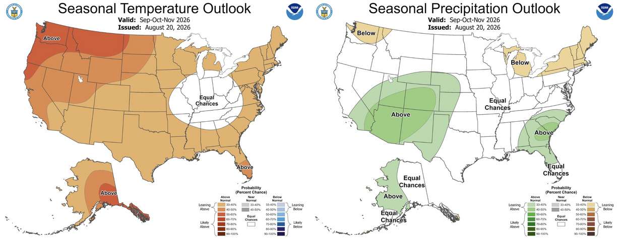
Odds lean toward above-normal precipitation lasting throughout most of Utah over the meteorological fall months of September, October and November, the National Weather Service Climate Prediction Center noted in its final three-month outlook ahead of the season released on Thursday.
Utah also has a stronger probability of above-normal temperatures persisting over the next three months, although it's unclear if it will continue its torrid pace that could make 2026 the state's warmest year on record.
It's a positive outlook as Utah continues to deal with severe and extreme drought, said KSL meteorologist Matt Johnson.
"This is a great signal," he said. "This is a signal you would see from a more active jet stream that's going to be impacting us."
What's driving the trend?
An El Niño pattern, when the Pacific trade winds weaken and allow warm ocean water to move toward the American coast, has already set up, along with the eastern Pacific's more active hurricane season. It could have contributed to Utah's recent monsoonal run.
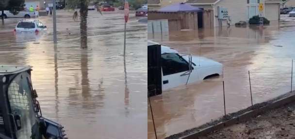
Utah experienced its 31st-wettest July on record, and August has already produced equally strong storms for parts of the state. El Niño, which primarily impacts winter weather, is strengthening, and there's a 90% chance that it will be "very strong" this winter, the Climate Prediction Center noted last week.
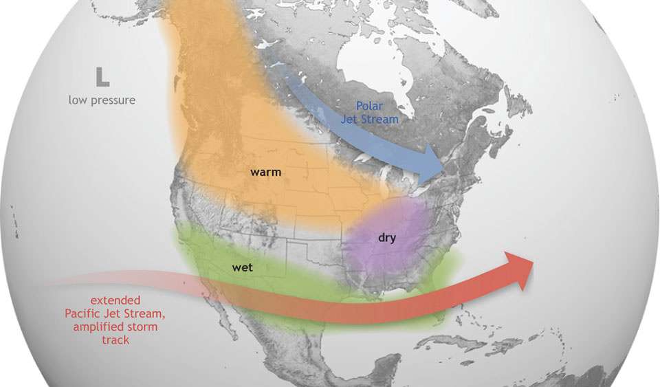
El Niño typically brings wetter conditions across the Southwest, with warmer, drier conditions in the Pacific Northwest. Utah's weather is normally caught between both El Niño and La Niña patterns, relying heavily on where the jet stream forms.
The center's fall outlook also follows this pattern, with precipitation odds strongest in southeast Utah. Northwest Utah has the lowest odds for precipitation, with "equal chances" projected for the region, meaning the odds of above-, below- or near-normal precipitation are approximately the same.
Southeast Utah also has the lowest odds for above-normal temperatures among the state's regions, with stronger odds within Utah's western and central ends. That could be influenced by a warm September, as the Great Basin has the strongest odds for above-normal temperatures within the country.
Fall moisture won't make or break Utah's reservoirs, which have now fallen to 52% capacity after a record-low snowpack last season, but it still plays a key role in the state's hydrology.
Mountain snowpack collection typically begins midseason, which is why every water year begins in October. Snowpack provides about 95% of the state's water supply.
Fall storms can also help boost soil moisture levels, which influences how efficiently snowpack melts in the following spring. Utah's average mountain soil moisture remains above normal from monsoonal storms, and a wet fall can continue that trend.
"If we put snowpack on really dry ground, we'll lose a lot of it like a sponge soaks up water," Johnson said.
Setting the stage for winter
The outlook suggests how models believe the storm pattern will play out this winter, Johnson adds. What's less clear is how much warmer the season could be and if that will factor into any snow that's collected.
This year's record-low snowpack developed while Utah experienced record-warm conditions, which began with last fall being the state's warmest on record. The state followed that with its warmest winter and second-warmest spring on record. This summer is still on pace to be the third-warmest on record.
Related:
Could a 'Super El Niño' deliver a big winter for Utah? Forecasters and resorts weigh in
A potential Super El Niño has Utah skiers and resort operators hopeful for a snowy winter, but forecasters caution that its impact on the state's snowpack remains uncertain.The biggest caveat in long-range forecasts is that they offer probabilities for precipitation and temperature relative to normal, but they don't indicate how large the difference could be.
"Whether we're going to see record-level warmth, in the way of temperatures, I don't know," Johnson said. "It may be a thing where we see mild afternoons, but not just a ton of cold air coming in."
The same goes for precipitation, but clearly all eyes are on how the season plays out. Gov. Spencer Cox said on Thursday that he's hopeful that El Niño will deliver this winter.
Preliminary outlooks favor strong moisture for Utah, although temperatures remain a question. More detailed outlooks are expected in November, closer to the beginning of the meteorological season.
"If we have another bad year, that means even more restrictions next year," Cox said. "But I feel really good about where we are."