Estimated read time: 4-5 minutes
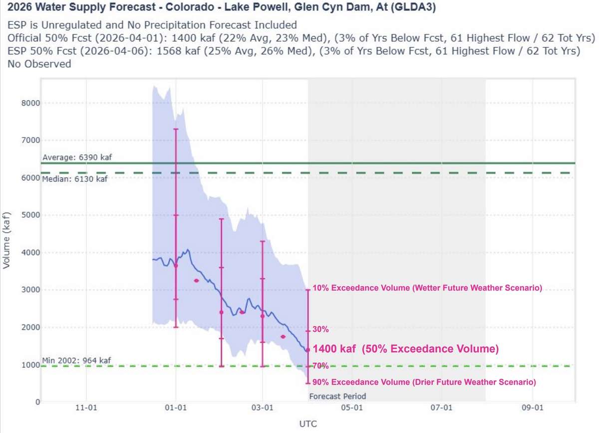
- Lake Powell's inflow is projected at 1.4 million acre-feet 22% of normal.
- March's warm and dry weather worsened conditions, increasing record-low runoff likelihood to 30%.
- Regional cooperation is need to prevent Lake Powell's critical status, Utah natural resources leader says.
SALT LAKE CITY — Lake Powell was already facing a near-record low snowpack runoff this spring, but the odds of this being its worst season on record have now increased after an abnormally warm and dry March.
The nation's second-largest reservoir, located between Utah and Arizona, is projected to receive inflows of 1.4 million acre-feet of water this year, which would be 22% of normal and the third-lowest on record, the National Weather Service's Colorado Basin River Forecast Center reported on Tuesday.
That's nearly 1 million acre-feet below the agency's March outlook. It adds that there's about a 30% probability that it could match or exceed the previous record low of nearly 964,000 acre-feet set in 2002, up from 10% last month. The likelihood will only increase if the warm and dry weather trends continue, says Cody Moser, a hydrologist for the center.
"If we were to see the normal (precipitation) and temperature now through the end of July, we would expect this to stay relatively (close to the projection). ... If we were to see 2002 precipitation and temperature now through the end of July, that would result in a new record low," he said during a presentation on the basin's conditions.
How did the outlook get worse? March ended up being incredibly warm and dry.
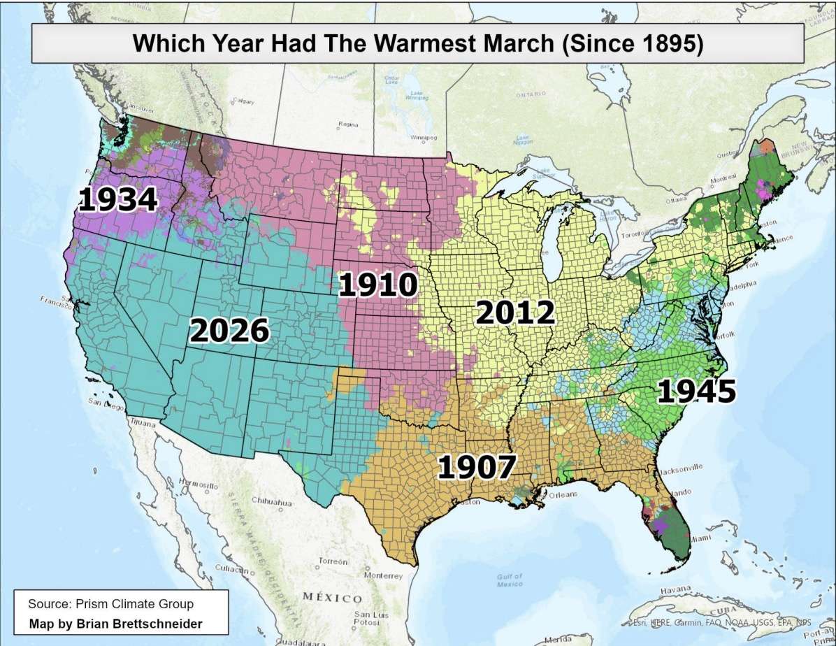
After a few storms, an unusually large high-pressure system settled over most of the West. Last month was the warmest March on record for counties from the Texas Panhandle to the Pacific Ocean, and southern Idaho through the Mexico border, according to the National Weather Service.
Many Natural Resources Conservation Service snowpack sites reported record- or near-record-low March snowpack collections, too. It sparked early snowmelt while also launching the irrigation season much earlier than anticipated.
Utah, Colorado, New Mexico and Wyoming — the four Upper Basin states that help feed Lake Powell — all entered April with record-low snowpack levels by significant amounts. Some streams and rivers within the Colorado River Basin may have already peaked, which is almost unheard of this early in the season, Moser said.
He acknowledges that there's still an error rate influenced primarily by future weather patterns. Cooler temperatures and moisture could help 2026 avoid additional unwanted records, but the error rate continues to shrink as the normal snow season ends. This year has also done nothing but basically hit the worst-case scenario because of record-warm conditions so far.
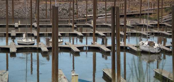
It couldn't have come at a worse time for the reservoir. It has already fallen to 3,528 feet elevation, approximately a quarter of its capacity.
Tough decisions are going to have to be made, like right now.
–Joel Ferry, director of Utah Department of Natural Resources
Meanwhile, the seven states that share the Colorado River have yet to shake an impasse over how to use it, as this winter is complicating an already complicated situation, said Joel Ferry, director of the Utah Department of Natural Resources.
"It's just a really tough situation," he told KSL. "You're talking about the lowest snowpack, the hottest temperatures that we've ever seen (during the snowpack season), and Lake Powell didn't start off in good shape to where we had kind of a bank account to draw from. ... We're in a really tough shape."
Ferry, who also serves as the state's water agent, said it's something Utah can't solve on its own. All seven basin states, and perhaps the federal government, will have to coordinate to prevent the reservoir from hitting levels that will harm energy production or, worse, its "dead pool" status in the near future.
"Tough decisions are going to have to be made, like right now," he added. "It's not good."
Outlooks worsen for Flaming Gorge, Utah streams and rivers
While some have suggested draws from Upper Basin reservoirs as a short-term solution for Lake Powell, Tuesday's report was discouraging across the entire region.
Flaming Gorge suddenly finds itself on pace for 490,000 acre-feet of water, which would be 51% of normal and its 10th-lowest snowmelt inflows in 64 years, according to the Colorado Basin River Forecast Center. Inflows range from 27% to 38% of normal at other reservoirs in the Upper Basin.
The agency also projects that snowmelts will be between 45% and 55% of average across the Bear, Weber and Provo rivers, and Big Cottonwood Creek, all of which would be in the bottom six peaks ever recorded for them. Peaks of 45% or lower are projected for the Virgin and Sevier rivers.
Last week's storms were "not insignificant," Moser said. Some additional storms are likely in the seven-day forecast, while long-range outlooks hint at more a week after that. That would also help, but time is running out on the season.
Utah's reservoir system remains at 73% full, and it may not gain much more with so much snowpack already melted.
Above-normal soil moisture levels are still reported across the Colorado River Basin, which means any extra snow is likely to end up in the river system. However, that won't always be the case, and Moser said there are already signs of that ending in low- and mid-level elevations after March.
Severe drought now blankets nearly 60% of Utah, and its growth will depend on how many storms affect the region over the coming weeks.
"It's weather dependent," he said.