- Winter storm warnings have been issued for mountain ranges across Utah's northern half.
- The region faces significant snowfall, with 1-3 feet expected in some areas.
- Some valley snow is also expected, especially Friday morning.
SALT LAKE CITY — After a slow start to the season, parts of Utah could soon be in line for its strongest wave of snow yet.
The National Weather Service issued a series of winter storm warnings and winter weather advisories that cover several mountain and valley areas across Utah's northern half, with some mountain ranges projected to receive as much as 1 to 3 feet of snow or more between Thursday night and Sunday morning.
It warns that snow "may be heavy at times" over the next few days, picking up on Friday morning, which can have "significant" travel impacts. However, it's also good news for Utah's water supply and snow recreation community.
"We have our fingers crossed, and we're hoping this thing pans out because right now it looks promising," says KSL meteorologist Matt Johnson.
Storm timing
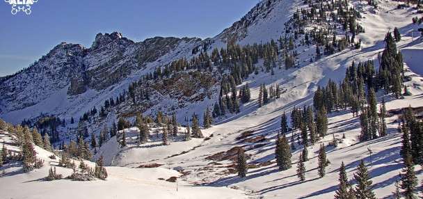
Utah has already benefited from a few small storms since Sunday, which delivered about a foot of snow in places like Alta. The next wave figures to be much bigger.
A narrow line of water vapor referred to as an atmospheric river is setting up in the Pacific Ocean, picking up a "nice tap of moisture" as it moves toward the coast, Johnson explains. It's forecast to make its way into northern Utah as it decays and continues east.
Moist West/Northwest flow will bring significant mountain snow to the northern and central Utah mountains and the Wasatch Back beginning late Thursday and persisting, on and off, through early Sunday morning. A winter storm warning has been issued for these areas. #utwxpic.twitter.com/vhfZ9sJWEm
— NWS Salt Lake City (@NWSSaltLakeCity) December 4, 2025
It's making its way through the Pacific Northwest on Thursday, and it's expected to reach northern Utah by Thursday night. Snow will pick up in intensity early Friday, as valleys and mountains mostly north of Salt Lake City receive snow, especially areas north of Ogden, Johnson said.
Showers may linger in the Wasatch and northern Utah regions late Friday, but a warmer punch is forecast to arrive Friday evening, bringing more valley rain and mountain snow. That will continue into early Saturday, with snow "heavy at times" in the mountains, he adds.
Valleys will begin to dry out by Saturday afternoon, but scattered mountain showers are possible into early Sunday.
Potential accumulations
The weather service's winter storm warnings run from 8 p.m. Thursday through 5 a.m. Sunday, covering several different areas with varying snow forecasts:
- 1 to 3 feet of snow is possible in the Wasatch and West Uinta mountains, with totals that could reach closer to 40 inches in the Bear River Range and upper Cottonwood Canyons. While one of its models projects Alta could receive 27 inches from the storm, the weather service states it has low-end and high-end projections ranging from 15 to 48 inches in that area.
- 4 to 16 inches of snow is possible in the central and Wasatch Plateau/Book Cliffs mountains. The higher totals are more likely in areas north of Manti, and the lower totals are projected for south of Manti.
- 6 to 16 inches of snow is possible at elevations above 5,500 feet in the Wasatch Back, and potentially 2 to 6 inches in areas below 5,500 feet.
Its winter weather advisories cover lower-elevation areas across northern Utah, including Brigham City, Logan and Garden City, where 2 to 6 inches of snow is possible between Thursday night and Friday morning.
Snow is possible in parts of the Wasatch Front, as well. Many communities from Provo to Ogden, and even parts of central Utah, could receive a trace to an inch or two of snow, especially during the initial wave, according to the weather service.
It could also deliver nice water totals. KSL Weather models suggest that it could deliver up to a half-inch of precipitation or more across the Wasatch Front and northern Utah, with over an inch of precipitation likely in the mountains.
"This will ... be the biggest storm yet," Johnson said.
Some parts of southern Utah could receive a bit of moisture, but it will likely skip the region.
Storm impacts
Travel may be "very difficult at times," especially along mountain passes and during the Wasatch Back's Friday commutes, the winter storm watch states. Traction laws are likely to be enforced across most mountain passes in Utah's northern half.
Utah Department of Transportation officials issued a road weather alert, advising drivers to exercise "high caution" traveling through Logan Canyon, Cottonwood Canyon and the Wasatch Back between Thursday night and Saturday morning. Friday night may have the worst road conditions, it added.
"Moderate caution" is recommended across many other parts of Utah's northern half, especially with periods of valley snow and slush expected Friday morning.
Road Weather Alert: A wet storm system will bring numerous rounds of snow (& some valley rain) late tonight through Sun AM. Lt rd snow for N. UT urban corridor Fri AM. Heaviest mtn snow Fri PM - Sat. For more info, visit: https://t.co/4P1gO2c9Uo#utsnow#utwx@UtahTruckingpic.twitter.com/QZ1gPyw5VE
— UDOT Traffic (@UDOTTRAFFIC) December 4, 2025
Meanwhile, the storm signals good news for Utah's water supply and resorts. Snowpack — the measure of water in mountain snow — remains below 50% of normal for this point in the season across nearly all of the basins in Utah's northern half. About 95% of the state's water supply is tied to snowpack, and the storm could help basins get back on track after the season's slow start.
Meanwhile, Deer Valley Resort announced it will begin operations on Friday, joining Park City Mountain, Snowbasin Resort, Alta Ski Area and Brighton Resort in opening this week with all the new snow.
Warmer and drier conditions are expected to return across the state by the start of next week, though, as a high-pressure system begins to move closer to Utah, Johnson said.
Full seven-day forecasts for areas across Utah can be found online at the KSL Weather Center.