- Utah's fire season has become more severe than initially forecast expected.
- This summer's slow monsoon season has increased drought and fire potential statewide.
- Over 140,000 acres in Utah have burned this year, more than the last three years combined.
SALT LAKE CITY — Utah leaders, state fire officials and other experts warned that this year's fire season could be "busier" than in years past when they gathered in May at This is The Place State Park to discuss the summer fire outlook.
They also hoped that the conditions would improve by August. The state was forecast to have normal fire risk by August after some regions were projected to have above-normal conditions in June and July, the National Interagency Fire Center Predictive Services estimated at the time.
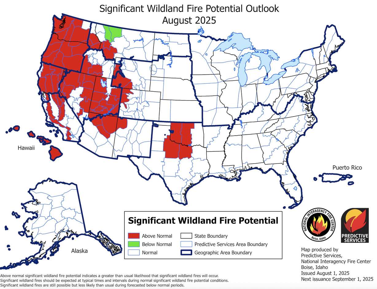
But August is here, and that is certainly not the case. The Monroe Canyon Fire — now the state's largest fire in five years — continues to burn in central Utah. Above-average fire danger has also set up across nearly every region in the state, according to the federal agency's final August fire potential outlook.
What happened?
Utah's dry summer so far
Fire outlook projections are based on current conditions and long-range forecasts. Utah's southern half had come off a rough winter snowpack, while its northern half was in the midst of a suddenly dry spring at the time. Long-range forecasts offered some hope that the North American monsoon could help out during the summer.
That said, monsoons are notoriously difficult to forecast, and long-range outlooks at the time weren't quite clear about what to expect outside of hotter-than-normal temperatures.
Most of the state was listed as having "equal chances" when it came to precipitation throughout meteorological summer, according to the National Weather Service's Climate Prediction Center. This meant there was no clear signal as to whether June, July and August, combined, would be wetter than, drier than or near a normal summer — even if the probabilities were generally favorable toward precipitation.
Things are much below normal, as far as monsoon activity goes.
–Sam Webber, National Weather Service
Experts were cautiously optimistic, at the time, because the state experienced a few late-season winter storms that could delay the start of the monsoon period or kill it off altogether. It's unclear if that's what happened in the months since, but this summer's monsoon has been mostly disappointing thus far.
"Things are much below normal, as far as monsoon activity goes," said Sam Webber, a meteorologist with the National Weather Service in Salt Lake City.
Utah, he explains, relies on a specific meteorological pattern to get its monsoonal moisture. A high-pressure system typically sets up over the Four Corners region over the summer, helping bring oceanic moisture up into the Southwest and into Utah.
This year, however, that system has predominantly set up south and east of where it typically does. A series of low-pressure patterns also set up over the Pacific Northwest, leaving Utah out to dry. Despite a few storms that broke through, this year's monsoonal moisture has generally ended up in areas south and east of the state as a result of these patterns.
It's partly why areas like New Mexico and Texas dealt with serious — and even deadly — flooding events this summer, while it's been relatively quiet in Utah. The weather service's Salt Lake City office has only issued 14 flash flood warnings this year, almost half of its 20-year normal for this point in the season.
Increasing fire danger
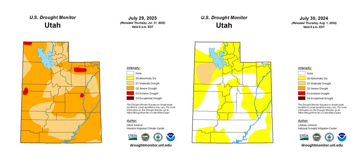
Utah could go without the flooding, but the lack of storms is problematic. Over 60% of the state is now in severe or extreme drought, while the rest is in moderate drought. Only 5% of the state was in moderate drought while 55% of it was "abnormally dry" heading into August last year.
The predominant weather pattern has also brought in more wind than usual. That mix of warm, dry and windy conditions has created more of a "fire weather pattern" this summer, prompting more red flag warnings, Webber adds.
The increasingly dry conditions have translated into the busier fire season that experts feared in May. Over 700 different fires have started this year, scorching more than 140,000 acres of land as of Monday. For reference, all of the fires reported in 2022, 2023 and 2024 burned 134,272 acres combined.
Long-range models don't offer much relief, either. Odds now lean more toward a drier-than-normal August for most of the state, which could linger into the start of the meteorological fall.
"That doesn't mean that we won't get intermittent period moisture surges. They're certainly possible," Webber told KSL.com, but he said this summer could go down as what meteorologists refer to as the "nonsoon" unless those storms produce strong precipitation.
This means Utah's fire season could remain active into the fall, even though Predictive Services' fall outlook currently lists Utah as dropping back down to normal fire risk by September.
State leaders have pushed more fire safety messages as this plays out.
"I'm begging people to please use extreme caution," Gov. Spencer Cox said on Friday. "One spark and we can have another fire just like this, and that means shrinking resources."