Estimated read time: 4-5 minutes
This archived news story is available only for your personal, non-commercial use. Information in the story may be outdated or superseded by additional information. Reading or replaying the story in its archived form does not constitute a republication of the story.
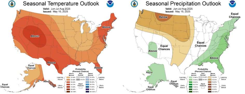
- Utah faces another hot summer, with a 65% chance of above-average temperatures.
- The Climate Prediction Center forecasts "equal chances" for precipitation, leaving uncertainty but hope for an active monsoon.
- Enhanced monsoons could aid drought-stricken areas in Utah.
SALT LAKE CITY — Utah could be in for another scorching summer after nearly breaking its all-time average seasonal temperature last year.
However, updated long-range outlooks continue to indicate that the state's driest regions are in line to benefit from a robust monsoon this summer.
Most areas throughout the Beehive State have about a 65% probability of posting above-normal temperatures throughout the collective meteorological summer months of June, July and August, according to the final three-month outlook released by the National Weather Service's Climate Prediction Center before the season begins on June 1. It's the highest probability of any state in the West.
Some parts of southwest Utah have lower probabilities, but these remain just under 60%, mirroring most of the region.
The same three-month outlook also lists most of Utah as having "equal chances" when it comes to precipitation. That means there is no clear meteorological signal to indicate whether this year will be wetter, drier or near a specific site's summer precipitation normal. Some parts of southwest Utah are listed as having a slightly higher probability of above-average precipitation, while the odds tilt slightly to more below-normal precipitation from about the Great Salt Lake northward.
Another hot summer?
The updated outlook seems to indicate that Utah is headed for a tale of two summers, according to KSL meteorologist Matt Johnson. With Utah appearing to have a temperature probability "bull's-eye," he says the models suggest that high-pressure systems might park over the state for "the majority of the summer."
High-pressure systems tend to heat up the land more quickly and keep storms away, sometimes leading to extreme heat events during the summer.
"It's definitely a telltale sign that we will be seeing warmer-than-normal temperatures," Johnson said.
The outlook only provides probabilities in terms of what is normal for the summer, meaning it's unclear if the three-month final average ends up just barely above normal or well above normal. However, it does fall in line with some of the past few summers.
Utah's hottest summer of the last 130 years came in 2021, followed by 2024 and 2018. All but one of the hottest summers occurred during the 2000s, per National Centers for Environmental Information data.
This has been especially true along the Wasatch Front during one particular month. July 2022, July 2021 and July 2023, respectively, account for Salt Lake City's three hottest months on record since data collection began in 1874.
The hottest months are typically led by a spike in the number of 100-degree days along the way, Johnson pointed out. Utah's capital city normally receives four 100-degree days per year, but that number has jumped to nearly a dozen over the past decade or so. There were 20 triple-digit days last summer alone.
The trend that could favor Utah
Yet, the second half of the summer could look different, especially in central and southern Utah, and possibly even up to the Wasatch Front.
History has linked below-normal snowpack seasons with productive monsoons, Johnson adds. This is likely tied to the drier soil moisture in areas that missed out on snow, which allows the land to heat up more quickly. That then pulls in the monsoonal windflow from the Southeast and East, bringing in Gulf moisture.
Federal forecasters seem to suggest that scenario could happen this summer. The probability of an "enhanced" monsoon across the Southwest is "weakly increased due to current negative soil moisture anomalies," Climate Prediction Center meteorologists wrote in a corresponding report last week.
As such, most of Arizona, as well as portions of Utah, California and Nevada are listed as having slightly higher probabilities for above-normal precipitation this summer in its outlook. Most of the rest of the Southwest is listed as having equal chances, depending on where monsoonal moisture winds up — something that's hard to predict.
The Southwest monsoon season typically begins in June but eventually reaches Utah in July and August. That said, more storms like one that brought cooler, wetter conditions to southern Utah over the weekend could also delay the start of the monsoon, said Basil Newmerzhycky, a meteorologist with the Great Basin Predictive Services, which helps forecast wildfire risk.
Above-normal precipitation would be a welcome sight, as over 70% of the state remains in drought, including over 40% — mostly in central and southern Utah — either in severe or extreme drought.
This pattern could also factor in the above-normal temperatures, Johnson adds. Lately, warmer overnight lows have also increased the state's average summer temperature. 2021, 2018 and 2024 top the record book in terms of average minimum temperature over the past 130 years; it just so happens that 2021 also tied for Utah's 18th wettest summer on record, showcasing how Utah can still have a wet year even with monsoons in place.
It's too early to know if 2025 will be a repeat of that, but Johnson says overnight lows could also factor into the projected hot summer ahead.
"We could still achieve a very much warmer than normal summer though the afternoon maxes might not be incredibly," he said.