Estimated read time: 4-5 minutes
This archived news story is available only for your personal, non-commercial use. Information in the story may be outdated or superseded by additional information. Reading or replaying the story in its archived form does not constitute a republication of the story.
- Utah's snowpack expert grades this year's collection a "C" despite near-normal levels.
- Statewide snowpack peaked early, with mixed results across regions.
- March storms improved spring runoff forecasts, but drought persists especially in southern Utah.
SALT LAKE CITY — After delivering back-to-back "A's," Utah's top snowpack expert says he's giving this year's collection a "C."
However, there's a lot of consideration that goes into his grade.
Utah's average snowpack reached 14.3 inches of snow-water equivalent on March 23, reaching either 89% or 100% of the state's median seasonal average depending on the Natural Resources Conservation Service figure you look at. It reached about 100% of the average peak in early April but 89% of the peak of any given year over the past 30 years, when reviewing water in the snow collected at more than 100 mountain sites scattered across the state since Oct. 1, 2024.
Although this year's statewide snowpack appears to have peaked more than a week earlier than usual, early April storms have helped keep the total close to normal as the snowpack begins to melt into the streams, creeks and rivers that fuel the state's lakes and reservoirs.
While that's nice, the statewide figure is skewed by an average season across northern Utah, almost hiding a decent season in central Utah and a near-record bad season in southern Utah, says Jordan Clayton, a hydrologist for the Conservation Service and supervisor of the Utah Snow Survey. Hence, his lower grade on the overall performance of this year's snowpack as compared to Utah's past two above-normal seasons.
"If we're concerned about the whole, the community ... and the whole community is benefiting in some ways but struggling in other ways — that doesn't sound like a great outcome to me, but it doesn't sound terrible either," he told KSL.com on Tuesday, recapping this season. "So I guess I'll have to give it a 'C.'"
How each snowpack basin fared
About 95% of Utah's water supply comes from the snowpack collection and the spring snowmelt process every year. This year's snowpack was a mixed bag, depending on where you live.
It was — as Great Salt Lake commissioner Brian Steed put it — a "remarkably average" season for Utah's northern half. Tooele Valley-Vernon Creek is the only basin that surpassed its 30-year median average, but the Raft and Provo-Utah Lake-Jordan basins each peaked at 99% of any given season over the past 30 years, barring any unforeseen major late-season storms.
Peak snowpack totals by basin
KSL.com reviewed Natural Resources Conservation Service data for every basin this season. The percentage of normal is based on a comparison to each basin's median average peak total for any given season during the normal period, between 1991 to 2020.
- Tooele Valley-Vernon Creek: 17.6 inches (103% of seasonal median average)
- Raft: 24.6 inches (99% of seasonal median average)
- Provo-Utah Lake-Jordan: 20.1 inches (99% of seasonal median average)
- Weber-Ogden: 20 inches (94% of seasonal median average)
- Bear: 18.4 inches (94% of seasonal median average)
- San Pitch: 13.3 inches (91% of seasonal median average)
- Beaver: 13.5 inches (88% of seasonal median average)
- Duchesne: 12.3 inches (86% of seasonal median average)
- Price-San Rafael: 12.3 inches (84% of seasonal median average)
- Northeastern Uintas: 9.9 inches (83% of seasonal median average)
- Dirty Devil: 9.4 inches (79% of seasonal median average)
- Lower Sevier: 11.9 inches (74% of seasonal median average)
- Southeastern Utah: 7.9 inches (72% of seasonal median average)
- Upper Sevier: 9.1 inches (65% of seasonal median average)
- Southwestern Utah: 6.2 inches (53% of seasonal median average)
- Escalante-Paria: 4.6 inches (48% of seasonal median average)
The Bear and Weber-Ogden basins also ended up at 94%, while the Great Salt Lake basin's total ended up at 95% of its seasonal average. The region benefited as storms picked up in frequency and intensity toward the end of the season. February and March accounted for nearly half of the whole collection for the season.
Those late-season storms were monumental for the rest of the state, too.
"We saw every basin in the state of Utah increase its percent of normal during the month of March," Clayton said, explaining that March's output was far above normal for what is typically one of the state's biggest snowpack production months. "That's really positive."

It helped many central Utah basins finish at over 80% of normal after lackluster totals through most of the season. The Beaver Basin — peaking at 88% — had very few gains after a major Thanksgiving storm, but that changed around Valentine's Day. Over half of its season total came after Feb. 13.
Meanwhile, the Escalante-Paria, Lower Sevier, Southeastern Utah, Southwestern Utah and Upper Sevier basins all ended meteorological winter on pace for record-low snowpack collections, but that changed over the past month. The five ended up posting totals ranging from 48% to 74% of their respective median averages this year.
Candice Hasenyager, director of the Utah Division of Water Resources, said last month that it's an improvement, but the totals were "dismal."
Projecting the spring runoff
March's run also changed Utah's water forecast, which is why the timing mattered. Recent moisture mixed with some early season runoff has improved statewide soil moisture levels, moving them closer to last spring's levels. That means more water is expected to flow into streams instead of flowing underground to recharge groundwater reservoirs than was expected earlier this year.
But, again, some regions are in better positions than others. Most northern Utah streams are now projected to provide 70% to 100% of the average spring runoff — some possibly reaching 112%, Clayton wrote in a Conservation Service report published last week.
Slightly lower normals are possible in central Utah, but the agency still expects runoffs to be 28% and 34% across most of southwest Utah, as dry soil conditions persist in the region that remains in extreme drought. That's because snowpack and soil moisture levels remain in the bottom 10th percentile for many parts of the region even after March.
That outlook is why Clayton lowered his grade on the statewide snowpack.
"That's a recipe for not getting much runoff," he said. "We are very concerned about that."
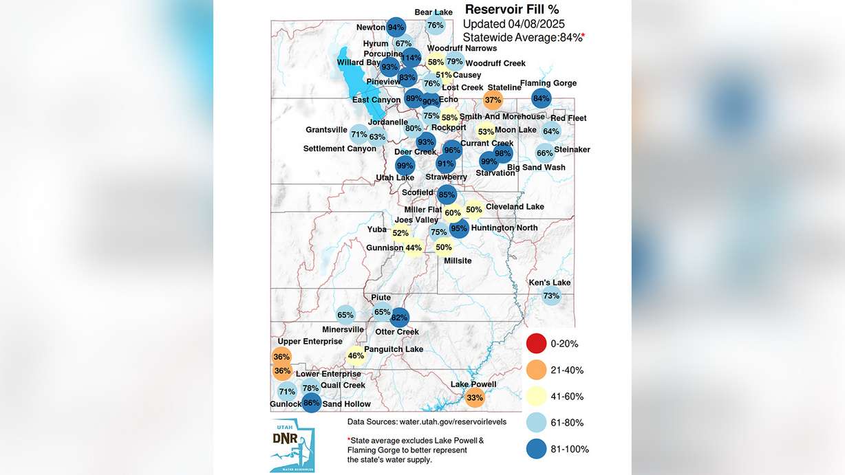
The good news is that Utah's reservoir system is now up to 84% full, which is much higher than normal for April. Larger reservoirs across southwest Utah are among those in a good position as the next irrigation season begins, but water experts caution that reservoirs in central and southern Utah likely won't refill the same way they have the last two springs.
That's why they're urging residents to use water wisely this year; it's impossible to know what next winter will bring.
"Let's conserve this summer and keep water in our reservoirs," Hasenyager said.