Estimated read time: 5-6 minutes
This archived news story is available only for your personal, non-commercial use. Information in the story may be outdated or superseded by additional information. Reading or replaying the story in its archived form does not constitute a republication of the story.
SALT LAKE CITY — July was the hottest month on record in Salt Lake City, but that wasn't the case in Salt Lake County or any Utah county for that matter.
In the end, only six Utah counties produced average temperatures in July that fell within their top five hottest since 1895, according to climate data released by the National Centers for Environmental Information on Monday.
- Davis County: 77.5 degrees (fourth-hottest on record)
- Juab County: 78.5 degrees (fifth-hottest on record)
- Millard County: 79.1 degrees (third-hottest on record)
- Morgan County: 70.4 degrees (fifth-hottest on record)
- Tooele County: 80.5 degrees (fourth-hottest on record)
- Weber County: 73.6 degrees (fourth-hottest on record)
With an average temperature of 75.3 degrees statewide, July was the sixth hottest on record in Utah. High minimum temperatures — the average low temperatures recorded daily — boosted the overall average temperature in Utah last month. Utah's average minimum of 60.9 degrees ended up the fifth-highest on record for July, while the average maximum temperature of 89.7 degrees, landed 13th all-time — despite Salt Lake City's record-smashing 18 total 100-degree days during the month.
This same trend played on a nationwide scale last month, which ended up the third-hottest July on record across the U.S. at 76.4 degrees. The country's average minimum temperature hit a record 63.6 degrees last month, breaking an all-time record set in 2012.
Precipitation levels improve
Monsoons may have helped bring the average temperature down in Utah. The Beehive State collected an average of 0.92 inches of precipitation in July, which was only less than a tenth of an inch below the 20th-century normal. It made last month the 59th-wettest or 70th-driest July on record, depending on how you view it.
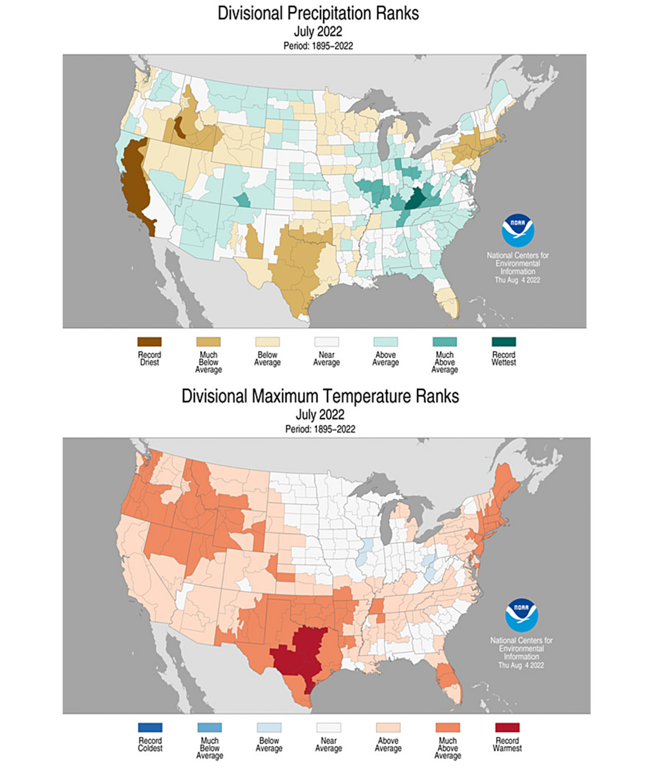
National Centers for Environmental Information maps show an interesting divide between northern and southern Utah in both average maximum temperatures and precipitation as monsoons impacted southern Utah more in July. In San Juan County, for example, the average maximum temperature was only the 33rd-hottest on record while it received its 54th-wettest July on record.
Despite the wetter July, far more precipitation is needed to get Utah back on track in terms of precipitation deficits. Utah is still on pace for its fourth-driest year on record even if it is currently on pace for its 25th-hottest year on record, through July. It's why the U.S. Drought Monitor still lists about 82.5% of Utah as being in extreme drought.
Utah was on pace for its third driest year on record after June.
August already seems to be much more productive. Utah's capital of Salt Lake City received 1.07 inches of rain in the first seven days of the month, which is not only about nine times more than it received in all of July but nearly double the entire August average from the past 30 years.
It's also helped cool the city down from its record-breaking July. The average temperature from the first seven days of August is 80.7 degrees, which is about 1.3 degrees below the normal of the past two decades, according to the National Weather Service.
More rain on the way
More rain is expected later this week, too. The National Weather Service reports that rain and thunderstorms are forecast to return to southern Utah beginning as early as Tuesday afternoon. Those storms are expected to venture up into the rest of the state later in the week and into the weekend.
💧Moisture will return back into our area this week after a few days of dry conditions. Southern Utah will see a return in rain and thunderstorm activity as early as Tuesday. Looking ahead, moisture remains into next week, allowing an above normal chance for precipitation. #UTwxpic.twitter.com/75P7G8ovPe
— NWS Salt Lake City (@NWSSaltLakeCity) August 7, 2022
"Moisture will return back into our area this week after a few days of dry conditions," the agency tweeted on Sunday. "Looking ahead, moisture remains into next week, allowing an above normal chance for precipitation,"
The National Weather Service's Climate Prediction Center on Monday listed all of Utah within a 40-60% probability of above-normal precipitation from this upcoming weekend through Aug. 18. Trends are also leaning toward above-average precipitation a week after that.
These trends won't erase Utah's drought, but they can help improve soil moisture conditions and ease wildfire risks.
A July juxtaposition
This week's rains also pose threats of flash floods beginning as early as Tuesday, especially in the outdoor recreation areas in southern Utah. This juxtaposition of drought and flash floods is something happening on a national scale, too, the National Centers for Environmental Information noted in its monthly report Monday.
The agency noted that drought in the U.S. grew by 3.7 percentage points from the end of June to the end of July, as the country's July precipitation average was four-hundredths of an inch below normal. More than half of the contiguous U.S. is now considered in drought, as the country remains on course for its 22nd-driest year on record.
However, many parts across the U.S. received above-normal or record-breaking precipitation, especially in eastern Kentucky. The region experienced devasting flooding that killed at least 37 people after a storm system stalled over the area in late July. Parts of St. Louis also received the most rain ever for one day on July 26, according to the center.
With places like Utah that are in line for — or have already received — above-average precipitation this August, the center does expect there to be "some improvement" to drought conditions in the West, while other parts of the country may have a drier August.
"Drought is likely to persist across much of Texas, parts of the West, Central Plains and Hawaii with some improvement and/or drought removal likely across parts of the Southwest, Central Rockies, south-central Plains and Puerto Rico," the report states. "Drought development is likely across portions of the Midwest and Northeast."