'%3e%3cpath%20d='M34.1406%205.85938C30.3906%202.10547%2025.3047%200%2020%200C14.6953%200%209.60938%202.10547%205.85938%205.85938C2.10938%209.61328%200%2014.6953%200%2020C0%2025.3047%202.10547%2030.3906%205.85938%2034.1406C9.61328%2037.8906%2014.6953%2040%2020%2040C25.3047%2040%2030.3906%2037.8945%2034.1406%2034.1406C37.8906%2030.3906%2040%2025.3047%2040%2020C40%2014.6953%2037.8945%209.60938%2034.1406%205.85938ZM37.0117%2023.543H31.1602V13.5391H27.6328V19.9414C28.1211%2020.6914%2028.3711%2021.582%2028.3711%2022.5625V22.625C28.3711%2023.668%2028.1172%2024.6055%2027.6328%2025.4297V26.6094H36.082C33.4883%2032.9375%2027.2891%2037.3789%2020.0039%2037.3789C10.3711%2037.3789%202.62109%2029.6289%202.62109%2020C2.62109%2010.3711%2010.3711%202.62109%2020%202.62109C29.6289%202.62109%2037.3789%2010.3711%2037.3789%2020C37.3789%2021.1484%2037.2617%2022.2656%2037.0508%2023.3477C37.0391%2023.4141%2037.0234%2023.4766%2037.0117%2023.543Z'%20fill='white'/%3e%3cpath%20d='M22.3086%2018.5352C20.4336%2018.125%2019.9531%2017.8398%2019.9766%2017.1836V17.1406C19.9766%2016.6992%2020.3477%2016.2148%2021.4023%2016.2148C22.582%2016.2148%2023.8867%2016.6797%2025.0781%2017.4766L26.8516%2015.0195C25.4453%2013.8906%2023.707%2013.3398%2021.5547%2013.3398C18.5195%2013.3398%2016.4375%2015%2016.4063%2017.4766V17.5352C16.3633%2020.2617%2018.5859%2020.9805%2021.293%2021.6016C23.0391%2021.9766%2023.5703%2022.3164%2023.5703%2022.9609L23.5469%2022.9766C23.5469%2023.3906%2023.2578%2023.7031%2022.7852%2023.8359C22.5742%2023.9062%2022.1289%2023.9727%2021.5156%2023.9727C20.7617%2023.9727%2019.7539%2023.8633%2018.6328%2023.4844C18.0898%2023.2891%2017.4727%2023.0039%2016.8047%2022.6133L20.1406%2026.625C20.2813%2026.6602%2021.0977%2026.8516%2021.7734%2026.8516C25.0039%2026.8516%2027.0859%2025.2461%2027.1094%2022.6328V22.5703C27.1602%2020.1133%2025.2148%2019.1719%2022.3086%2018.5352Z'%20fill='white'/%3e%3cpath%20d='M5.24219%2013.5664V26.6133H8.75391V23.7578L10.2969%2021.9531L14.2031%2026.6133H18.3867L12.3555%2019.5195L17.4023%2013.5664H13.4531L8.75391%2019.0586V13.5664H5.24219Z'%20fill='white'/%3e%3c/g%3e%3cdefs%3e%3cclipPath%20id='clip0_97_2430'%3e%3crect%20width='40'%20height='40'%20fill='white'/%3e%3c/clipPath%3e%3c/defs%3e%3c/svg%3e)


Estimated read time: 4-5 minutes
This archived news story is available only for your personal, non-commercial use. Information in the story may be outdated or superseded by additional information. Reading or replaying the story in its archived form does not constitute a republication of the story.
SALT LAKE CITY — The National Weather Service on Thursday issued a winter weather advisory for another snow-producing spring storm headed Utah's way, though it may not be as strong as one earlier this month.
Still, meteorologists say it has the potential to drop another 8 to 16 inches of snow or more in the Wasatch and West Uinta mountain ranges once it arrives Friday. And that's important for the state's water supply, said KSL meteorologist Grant Weyman.
"This is great news for the snowpack. Yes, we're past our peak and the runoff is starting in some places, but ... any snow we get this time of the year is going to count," he said.
The storm pattern is moving in from the Pacific Northwest, where it has already produced a mixture of rain and snow from northern California through Washington. It's expected to arrive in Utah Friday morning and linger in the state through Saturday, producing rain — and possibly thunderstorms — in the valleys, and snow in the mountains.
Warm and wind before the storm
Wind will be the major weather factor all across the state before the storm arrives, even as temperatures jump into the 70s across the Wasatch Front Thursday.
The weather service issued several wind advisories throughout the state, where southerly winds are expected to provide wind gusts up to and exceeding 50 mph throughout the day.
"Use extra caution when driving, especially if operating a high-profile vehicle. Secure outdoor objects," the advisory states.
Another spring storm
Those strong winds will eventually die down as the storm system arrives Friday morning. The winter weather advisory goes into effect at 6 a.m. Friday and remain in effect through noon Saturday, with places like Alta, Brighton, Logan Summit, Mantua, the Mirror Lake Highway and Moon Lake impacted most by snow.
While snow accumulations are projected to be 8 to 16 inches between Friday and Saturday, the advisory adds, some totals may be higher in the upper Cottonwood canyons.
"Occasional winter driving conditions are possible on mountain routes. Traction restrictions may be enacted," the alert states. "Slow down and use caution while traveling."
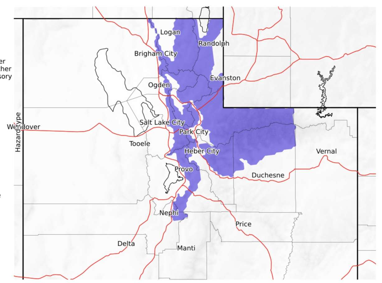
The weather service's Salt Lake City office tweeted that the snowline is projected to be about 6,000 to 6,500 feet elevation. That means places above that will receive snow, while everywhere below that will end up with rain.
KSL Weather models updated Thursday morning show the storm has the potential to provide a half-inch to an inch of rain between Provo and Logan, and a quarter of an inch to one-third of an inch in central and southern Utah. St. George, Kanab and Moab may even receive close to or more than 0.10 inches.
Full seven-day forecasts for areas across Utah can be found online, at the KSL Weather Center.
Snowpack additions
Most importantly, the model projects somewhere between 1 to 2 inches of snow water equivalent for the Wasatch Mountains, tacking onto the snowpack. Snowpack and snowmelt system accounts for about 95% of the state's water supply.
As of Thursday, the state's snowpack is about 70% of the average for this point in the season, which is normally snowmelt, not snow collection. The statewide figure peaked at 12 inches of snow water equivalent on March, which was 2.2 inches below the 30-year average and about two weeks before the typical peak.
However, last week's storm was strong enough to add 1 inch of water to the statewide figure. If the incoming storm does the same, the state still may end up collecting as much snow water equivalent, overall, as the 30-year average, even if it's not in the more conventional way in winter.
"It's going to flow in (the streams and reservoirs) and it's going to definitely help with the water situation, so this is a good storm coming our way," Weyman said.
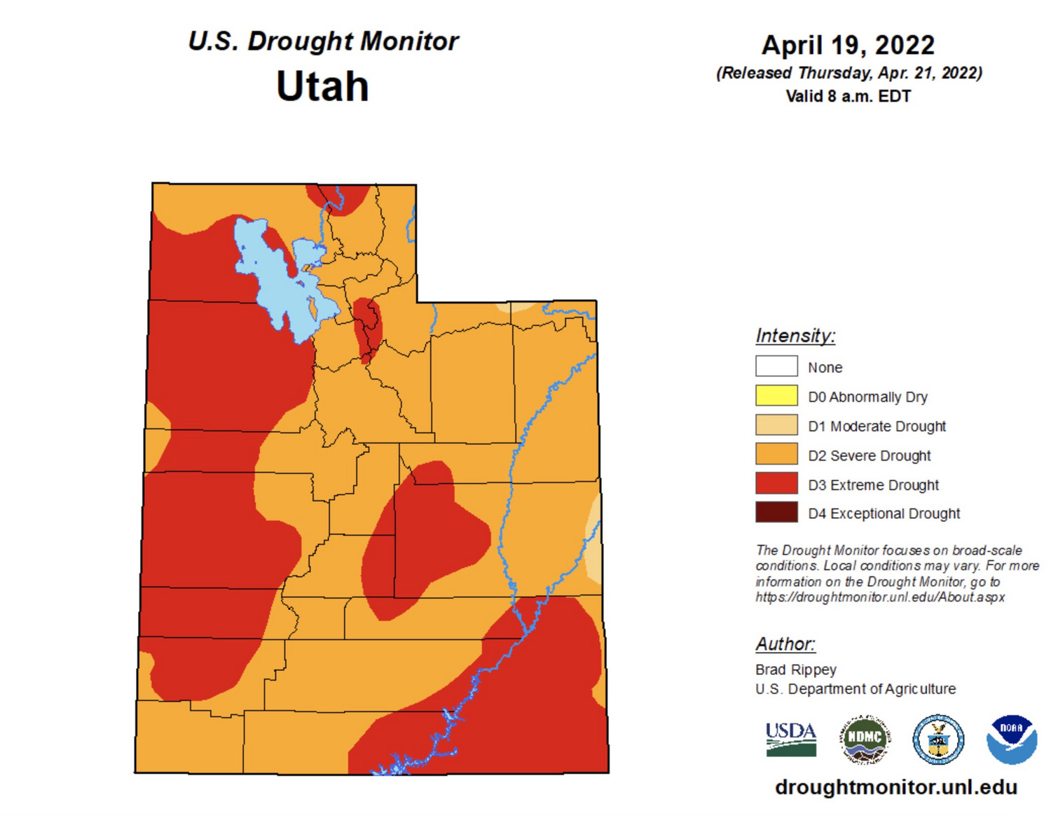
Though an average snowpack won't solve the statewide drought, every bit of water helps. The U.S. Drought Monitor updated its drought map Thursday, listing about 43.5% of Utah in an extreme drought, an increase of about 6.5 percentage points from last week's map. Over 99% of the state is listed in a severe drought.
The ongoing drought situation is why some Utah water districts and municipalities have already started restrictions as the irrigation system begins.