Estimated read time: 4-5 minutes
This archived news story is available only for your personal, non-commercial use. Information in the story may be outdated or superseded by additional information. Reading or replaying the story in its archived form does not constitute a republication of the story.
SALT LAKE CITY — This week's storm, which caused headaches in the form of crashes, downed trees and power outages in some places, proved to be helpful in terms of Utah's water supply.
While it won't solve the impending runoff shortages, the statewide snowpack, which was quickly deteriorating as a result of an early melt, received a welcomed spike in new water in the freshly fallen snow.
The storm dumped as much as 17 inches of snow in the Farmington Canyon area among Natural Resources Conservation Service sites in Utah. The National Weather Service's Alta station also received close to 17 inches of snow Tuesday and Wednesday.
The statewide snowpack had fallen from 12 inches on March 22 to 8.5 inches on Monday. This week's storm has since padded 0.8 inches of water statewide, according to Natural Resources Conservation Service data collected Thursday morning.
It's now back up to 9.3 inches, or 72% of normal for mid-April. It had fallen to as low as 64% of average ahead of the snowfall.
"Seventy percent of normal is still well below where we want to be; however, it's a boost, and we will definitely take these boosts," Jordan Clayton, supervisor of the Utah Snow Survey, told KSL-TV Wednesday.
Since the storm predominantly focused on northern and central Utah, the snowpack basins there mostly hoisted the statewide average. The Provo River-Utah Lake-Jordan River basin, for example, gained an inch of water, on average over the past few days, moving back to 11.4 inches, about 68% of normal.
- The Bear River basin gained 1.4 inches of water to move up to 12.2 inches overall, 78% of normal
- The Weber River-Ogden River basin gained 1.3 inches to return to 12.3 inches of water, 70% of normal
- The Beaver River basin gained 0.5 inches (0.3 inches have since melted). There's currently 13.2 inches of water in the southwest Utah basin, which means it remains the closest to normal this year at 93%
There were also some big winners in terms of individual sites making snow water equivalence gains between Saturday and Wednesday:
- Doc Daniel Experimental Forest (Cache County): 2.5 inches
- Trial Lake (Summit County): 2.4 inches
- Tony Grove Lake (Cache County): 2.3 inches
- Upper Parleys Canyon (Salt Lake County): 2.1 inches
- GBRC Meadows (Sanpete County): 2.1 inches
More could be on the horizon. The National Weather Service Climate Predication Center issued an outlook for April 21 through April 27 on Wednesday, listing almost all of Utah with a 33% to 40% probability for above-normal precipitation. It also lists most of the states are leaning toward stronger chances for below normal or normal temperatures during the same timeframe.
But for as much as this week's storm helped, Candice Hasenyager, the director of the Utah Division of Water Resources, says more needs to fall to make a difference in water use recommendations this year. Some regions and municipalities have already started enacting water restrictions, especially as the Climate Prediction Center's three-month precipitation outlook is not very promising.
Salt Lake City, for instance, announced Tuesday that it will remain at the second phase of its water shortage plan. The Weber Basin Water Conservancy District also made hefty restrictions, which were announced earlier this month.
"The storms add a little bit more and hold what snowpack is up there, but it's not really changing our water supply outlook," Hasenyager said.
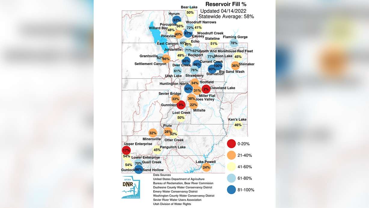
The statewide reservoir system is currently at about 58% of capacity, according to the Utah Division of Water Resources. Most of the state's reservoirs will fill up more as the snowpack melts; however, the largest reservoirs like Lake Powell, Utah Lake and Flaming Gorge likely won't change as much as smaller reservoirs given the vast size of the bodies of water.
Another bonus from this week's storm is it also helped in terms of water consumption, Hasenyager adds. It's one less week that people need to water their lawns. The division currently recommends that nobody waters their yards except for Washington County residents, who are advised to water only once a week.
"I think waiting to water is the No. 1 thing that residents can do," she said. "Because of the snow and the cold temperatures, that is really encouraging residents to wait to water."
Contributing: Jed Boal