Estimated read time: 2-3 minutes
This archived news story is available only for your personal, non-commercial use. Information in the story may be outdated or superseded by additional information. Reading or replaying the story in its archived form does not constitute a republication of the story.
SALT LAKE CITY — Two Utah Highway Patrol troopers were hit but uninjured while investigating separate crashes in Salt Lake County on Monday as snowy weather hit the Beehive State.
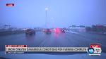
As of 11 a.m., Utah Highway Patrol troopers had investigated 53 crashes across the state, the agency said. By 5 p.m., that number had jumped to 147 crashes. Just a few hours later, UHP said they had investigated 270 crashes and two troopers had been hit while investigating separate crashes.
One trooper was hit twice at 7100 South on northbound I-15, and the other was hit once at 1100 West on I-80. Both were uninjured, UHP officials said.
UHP asked Utahns to avoid driving Monday night if possible. The agency was also backlogged with another 25-30 crashes as of 9:30 p.m.
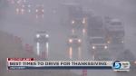
Snow is in the forecast for much of northern Utah throughout Thanksgiving week, with one storm hitting the Wasatch Front on Monday and another system moving through on Thursday and Friday, according to the National Weather Service.
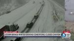
Tire chains or four-wheel drive were required Monday morning for all vehicles in Little Cottonwood and Big Cottonwood canyons, according to the Utah Department of Transportation.
Traffic was flowing normally in both directions in Little Cottonwood Canyon after a truck overturned about 8 miles into the canyon, near Tanners Flat Campground, according to UDOT. The road was briefly closed in both directions, but it had reopened by 1:20 p.m.
U.S. Highway 89/91 through Sardine Canyon in Cache Valley was also closed in both directions Monday morning, but fully reopened as of 11:15 a.m., according to Cache County emergency dispatchers.
Valleys in northern Utah were expected to see 1-4 inches of snow through Tuesday, according to KSL Meteorologist Grant Weyman. Areas in the benches could see 3-6 inches and mountains could get 6-12 inches, he said.
With all this talk of snow and storms, what are the main points to know? Those planning holiday travel, particularly on Thursday and Friday, will need to continue to monitor forecasts. #utwxpic.twitter.com/60Xt1gf6vd
— NWS Salt Lake City (@NWSSaltLakeCity) November 24, 2019
“It starts in the northern Wasatch Front, sweeps through the Salt Lake Valley and then into Utah County, and then eventually into the central part of the state by late afternoon,” Weyman said.
More snow is expected through the rest of the week, with showers possible every day through Friday, Weyman said. After that, snow showers will diminish but cold weather will move into the Wasatch Front, with low temperatures forecast in the teens for Saturday and Sunday, according to the KSL Weather forecast.
WINTER STORM on the way.... Here's what we expect out of the storm today. pic.twitter.com/zoLovtBPiL
— Grant Weyman (@KSLweyman) November 25, 2019
Get the full weather forecast at ksl.com/weather.
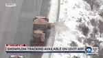
More traffic information is available from UDOT at udottraffic.utah.gov.

Related links
Related stories
Most recent Utah stories
Related topics
 Jacob Klopfenstein