- Almost 70% of Utah is now in at least severe drought, per U.S. Drought Monitor.
- Three more resorts to close this weekend amid record-breaking temperatures.
- Snowpack levels dropped significantly but a potential storm could bring relief next week.
SALT LAKE CITY — Most of Utah is back in severe or extreme drought again, as record-breaking temperatures have dominated what is traditionally the peak of the snowpack collection season.
Close to 70% of the state is in severe or extreme drought — an increase of nearly 25 percentage points from last week, the U.S. Drought Monitor reported on Thursday. Over 98% is in at least moderate drought, which is no different from the previous report.
In an adjoining report, Rocky Bilotta, a physical scientist for the National Centers for Environmental Information, blamed the increase on "anomalous warmth" that set up across the West over the past week.
Daily high temperature records have been shattered since a strong high-pressure system set up over the West last week, bringing June-like temperatures in March and no precipitation.
Salt Lake City broke a March record with an 84-degree day on Saturday, but it's had four other 80-degree days so far this month. The National Weather Service has tracked the city's weather since 1874 and has only recorded one 80-degree day in March before this year.
Provo fell a degree shy of having its first-ever 90-degree March day on Wednesday. This week's Drought Monitor report is the first to capture conditions since the system arrived.
"The combination of soaring temperatures, lacking precipitation and declining soil moisture and streamflow data resulted in broad drought degradation," Bilotta wrote, noting that southern and eastern Utah were among the localized regions that suffered most from the record-breaking warmth.
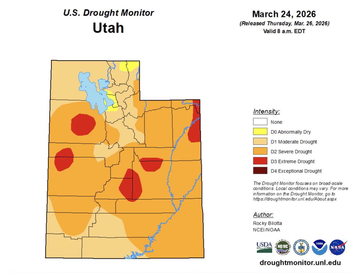
Extreme drought expanded in northeast Utah, while severe drought now blankets eastern Utah, as well as most of central and southern Utah. Northern parts of Cache and Rich counties, as well as the northern end of the Wasatch Front, are the only areas not in moderate drought, but the Drought Monitor still lists the areas as "abnormally dry."
Parts of Arizona, California, Idaho, Montana, New Mexico and Oregon experienced drought expansion, too, he added.
However, the worst drought conditions in the West remain in western Colorado, where some areas have fallen into the worst category on the Drought Monitor. Nearly 60% of the Centennial State is in at least severe drought, including close to a quarter in extreme or exceptional drought.
More ski resorts to close, but snow could return soon
The record-setting heat is also closing down more ski resorts this weekend. Deer Valley Resort announced on Thursday that it will close for the season on Sunday, much earlier than usual.
Powder Mountain is also set to close on Sunday, while Beaver Mountain will close on Friday, according to Ski Utah. A handful of other resorts have already shut down for the season amid the state's low snowfall.
Utah's statewide snowpack has fallen to 4.2 inches of snow water equivalent, having lost about half of its potential peak set on March 9 in the heat. Its current peak is about half of the annual average and 2 inches below the previous record low since the 1980s, per Natural Resources Conservation Service data.
The statewide snowmelt also began about a month earlier than the average. Some of Utah's resorts are still open, as stormy activity could return to the state next week.
Long-range forecasts hint that a large low-pressure system will return to the West next week, bringing cooler temperatures, valley rain and mountain snow, said KSL meteorologist Matt Johnson.
MOUNTAIN SNOW: An early look at next week's snow plume plot shows 1-2 FT for Alta Ski Area. Still a healthy lead time until this hits, but it's sure a lot better than record heat! I'll be updating! #utwxpic.twitter.com/15NxGj1c9R
— Matthew Johnson (@KSL_Matt) March 26, 2026
University of Utah Weather Center models, as of Thursday, suggest it could deliver 1 to 2 feet of snow or more near Alta next week, with the amount possible depending on how it sets up. That would help resorts and water managers alike.
"We're going to wait, hold and watch for that thing, and hopefully it pans out for us because we have been very dry lately," Johnson said.
Full seven-day forecasts for areas across Utah can be found online at the KSL Weather Center.