- Utah faces increased fire risk due to heat, drought and low snowpack.
- El Niño's development may influence the severity of Utah's fire season this summer.
- Gov. Cox urges caution to prevent human-caused fires as risks grow statewide.
SALT LAKE CITY — While Gov. Spencer Cox mulls a drought-related emergency declaration, he says he's also concerned by the growing fire danger expected in the coming months.
Human-caused fires, including last month's Goshen Canyon Fire that burned 408 acres in Utah County, accounted for approximately 85% of the 117 fires reported in the state by the end of April.
"Usually, as Utahns, we start thinking about fire in July and August — we start being more careful. We have to start now, Cox told KSL Friday. "Sadly, because of the heat, the drought and the lack of snowpack, we are already well within fire season."
The governor recommends that people properly extinguish campfires, avoid target shooting near rocks, avoid parking on dry grass and take steps to prevent any chains from dragging on vehicles, all of which are common human-caused starts. He met with TNT Fireworks executives on Thursday to discuss the fire situation, including possible restrictions in July.
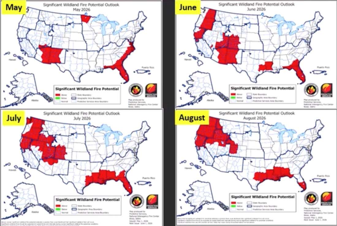
Above-normal fire conditions are projected across southwest Utah and northwest Arizona in May, according to the National Interagency Coordination Center. The agency lists the rest of the Great Basin, including most of Utah, as having normal fire conditions this month. It also projects that above-normal fire risk will develop across most of Utah, including the Wasatch Mountains, by June and all of the state by July.
However, how severe this summer's fire season gets may be determined thousands of miles away in the Pacific Ocean. An El Niño oceanic pattern is projected to develop this summer and last through at least the rest of the calendar year, according to the National Weather Service's Climate Prediction Center.
It will likely influence how the Western monsoon develops, which will then factor in this year's fire season, said Gina Palma, a fire meteorologist with the Great Basin Coordination Center, in a monthly and seasonal fire potential outlook that the agency released on Friday.
"This will be a big driver of what happens to our fire season," she said. "Right now, we have a lot of potential going into the fire season — especially in those higher elevations — with the lack of snowpack, and even some lower elevations where we're seeing some carryover, and some of that new (vegetation) growth."
Why fire risk is increasing
Utah's current fire situation is tied to a record-low snowpack, as record-high temperatures have plagued most of the West since the water year began in October.
April was milder and wetter than March across Utah, but it was still a few degrees above normal across most of the state. The West Desert and northwest Utah also didn't benefit from storms as much. And despite the moisture, Utah's average soil moisture levels dipped from above-average much of this water year to slightly below it in recent weeks, likely through an early snowmelt.
Above-average temperatures are projected to be a trend for May, June and July, with Utah having some of the strongest odds for above-normal temperatures across the next three months, according to the Climate Prediction Center.
"The more confusing part and the part that's not as certain is definitely the precipitation pattern in the West," Palma said, adding that May might continue to be on the "wetter side" for the Great Basin, but conditions may begin to dry out in late May or June.
El Niño's influence
Meteorologists aren't sure what to expect because of El Niño. It traditionally creates warmer conditions for the northern half of the West and wetter conditions across the Southwest, while Utah has historically been caught between the two, sometimes experiencing either trend.
How it develops and when may determine the rest of the fire season.
El Niño can produce systems along the West Coast that could push monsoons to the east or weaken their development, Palma explained. It can also create an "enhanced tropical season" in the eastern Pacific Ocean, with hurricane remnants potentially delivering more moisture than can be pushed into the Great Basin region.
"That's all dependent on when El Niño develops," she said. "If it develops late and we get that troughy pattern late, we could actually see the monsoon develop relatively on time before the El Niño really kicks in. That'll be something we're watching because obviously we are very reliant on that monsoon moisture or any moisture coming up from the South to put an end or a damper on our fire season in the Great Basin."
Long-range forecasts hint at above-normal conditions breaking through for most of the state by August, but it will depend on the right conditions lining up. Confidence in these forecasts remains low for now due to uncertainty, Palma cautions.
The National Interagency Coordination Center projects that all of Utah will have above-normal fire potential by July, as it stands. That's expected to dip down to normal for most of the state by August, while risks could increase in northern Utah and southern Idaho at that point.
Utah is prepared for the fire season, but it "could be one of the worst wildfire seasons we've ever seen," Cox said. El Niño could be a determining factor in that.
"The summer pattern can make or break that fire season," Palma said.