Estimated read time: 4-5 minutes
SALT LAKE CITY — Utah's capital city nearly doubled its summer precipitation collection through one storm that passed through Salt Lake City International Airport on Monday afternoon, but experts say more monsoonal moisture is needed to reverse a drying trend across the Wasatch Front and the rest of the state.
Salt Lake City received 0.40 inches of rain at its official recording site on Monday, nearly matching its season total since meteorological summer began. It had received 0.44 inches of rain since June 1, creating a summer deficit. While summer is the driest season in the region, the city normally receives about 2.02 inches.
Alta, in Little Cottonwood Canyon, collected 0.95 inches of rain after receiving just 0.81 inches throughout June and July.
Both are representative of the Wasatch region and northern Utah, which also got a major boost on Monday. One station in eastern Lehi received close to 2 inches of rain, while parts of central Utah and northward — including Herriman, Heber City, Dugway, Salina, Nephi and Kaysville — all ended up with over an inch of rain.
"It was, for some of us, a pretty rainy day," said KSL meteorologist Matt Johnson.
More scattered storms are expected across the state throughout Tuesday, some of which may produce equally heavy downpours across parts of the Wasatch Front, as well as northern, central and eastern Utah. Johnson said some "spotty" showers are possible on Wednesday.
The downside is a potential for flash flooding that exists, but all of the rain is also welcomed because of Utah's drying conditions this summer.
A drying trend
Utah's average mountain soil moisture had fallen to about 35% of saturation by the end of July, a level that's drier than normal for that point in the summer, the Natural Resources Conservation Service noted in a report published last week.
It's not just the lack of moisture; this summer has also been hotter than normal. Per federal climate data, Utah ended July on pace for its second-hottest and 19th-driest meteorological summer since at least 1895.
Both St. George and Salt Lake City even snapped long heat streaks with storms this week. St. George's run of consecutive 100-degree days ended at 52, two shy of its record. On top of its rain Monday, Salt Lake City snapped a run of hitting at least 90 degrees that started on July 5. The 38-day stretch tied similar runs in 1960, 1961, 2004 and 2020 for the fifth-longest on record.
All of this paved the way for drying soil moisture.

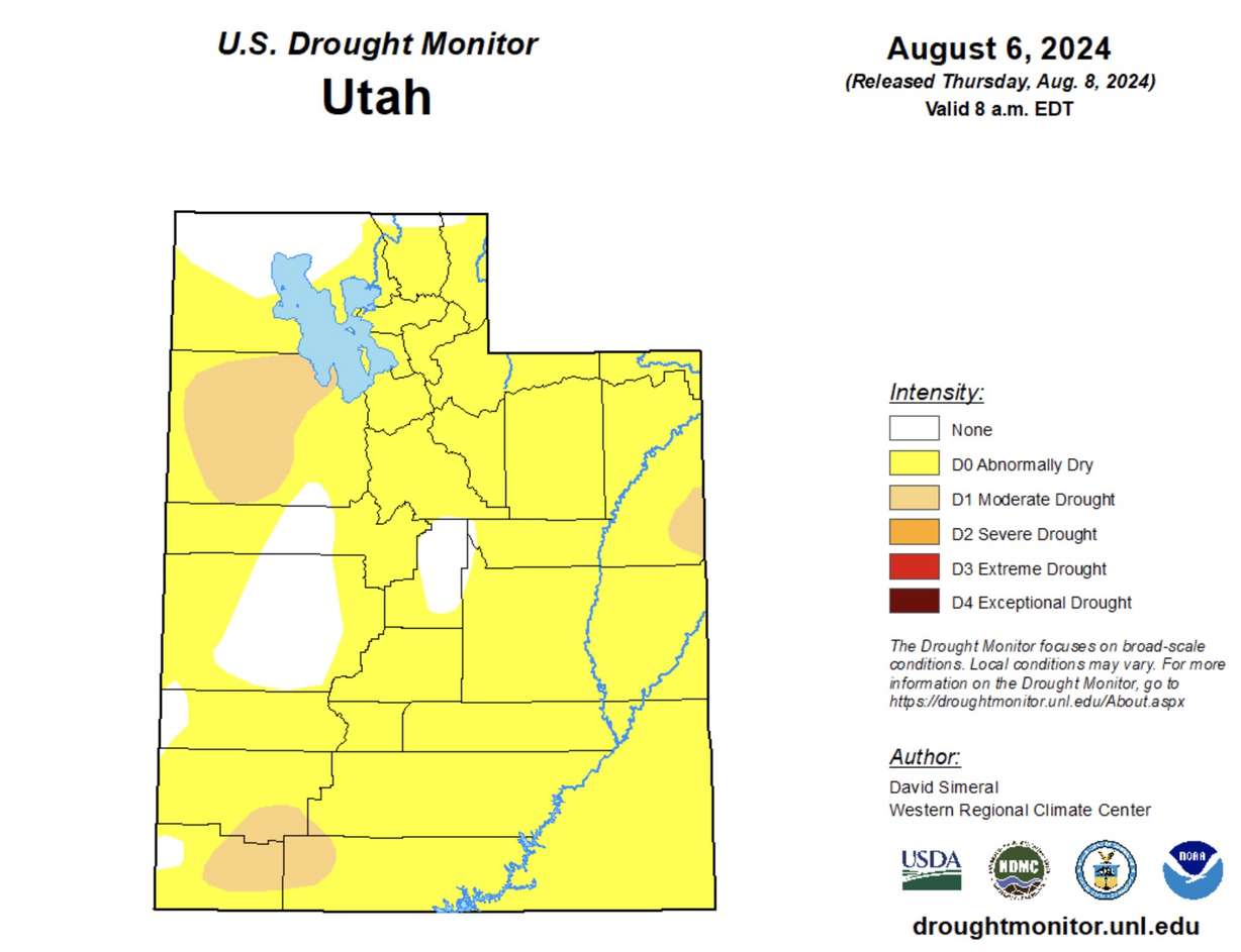
Utah slipped back into moderate drought and "abnormally dry" conditions in recent weeks. The U.S. Drought Monitor now lists nearly 90% of the state as least abnormally dry, including about 8% — small pockets in northwest, southwest and eastern Utah — that have returned to moderate drought.
Jordan Clayton, a hydrologist for the Conservation Service, wrote in the agency's report that the quickly drying conditions were somewhat reminiscent of 2020, where an average snowpack gave way to Utah's driest calendar year on record. That's a concern because drier soil moisture levels in the summer and fall can negatively impact the following spring's runoff efficiency.
The snowpack collection and spring runoff cycle accounts for about 95% of Utah's water supply. Clayton added that 2020's extremely dry summer and fall "contributed to exceptionally poor runoff conditions the following spring."
"We are really hoping to avoid a repeat of the 2020 summer," he wrote.
Some is good, more is better
That's where this week's storms help, but more will be needed to reverse what has been a mostly dry summer, said Glen Merrill, a meteorologist for the National Weather Service's Salt Lake City office.
The weather service's Climate Prediction Center offers both good and bad news when it comes to that.
The center lists most of Utah as having an increased chance for above-normal precipitation over the next two weeks. But its current three-month outlook lists the state as having a greater chance for below-normal precipitation.
That could pose problems because Utah's precipitation normally picks up in September, as the monsoon season wraps up and storms from the Pacific return. The state's new water year begins on Oct. 1 because that's usually about the time mountains begin to receive snow again.
Experts hope that soil moisture levels can rebound by then.
"Bottom line, (this week's storms are) going to help recharge the soils for the short term," Merrill said. "But we need to keep getting this moisture to maintain a good balance with the soils moving forward."
Contributing: Daniel Woodruff


