'%3e%3cpath%20d='M34.1406%205.85938C30.3906%202.10547%2025.3047%200%2020%200C14.6953%200%209.60938%202.10547%205.85938%205.85938C2.10938%209.61328%200%2014.6953%200%2020C0%2025.3047%202.10547%2030.3906%205.85938%2034.1406C9.61328%2037.8906%2014.6953%2040%2020%2040C25.3047%2040%2030.3906%2037.8945%2034.1406%2034.1406C37.8906%2030.3906%2040%2025.3047%2040%2020C40%2014.6953%2037.8945%209.60938%2034.1406%205.85938ZM37.0117%2023.543H31.1602V13.5391H27.6328V19.9414C28.1211%2020.6914%2028.3711%2021.582%2028.3711%2022.5625V22.625C28.3711%2023.668%2028.1172%2024.6055%2027.6328%2025.4297V26.6094H36.082C33.4883%2032.9375%2027.2891%2037.3789%2020.0039%2037.3789C10.3711%2037.3789%202.62109%2029.6289%202.62109%2020C2.62109%2010.3711%2010.3711%202.62109%2020%202.62109C29.6289%202.62109%2037.3789%2010.3711%2037.3789%2020C37.3789%2021.1484%2037.2617%2022.2656%2037.0508%2023.3477C37.0391%2023.4141%2037.0234%2023.4766%2037.0117%2023.543Z'%20fill='white'/%3e%3cpath%20d='M22.3086%2018.5352C20.4336%2018.125%2019.9531%2017.8398%2019.9766%2017.1836V17.1406C19.9766%2016.6992%2020.3477%2016.2148%2021.4023%2016.2148C22.582%2016.2148%2023.8867%2016.6797%2025.0781%2017.4766L26.8516%2015.0195C25.4453%2013.8906%2023.707%2013.3398%2021.5547%2013.3398C18.5195%2013.3398%2016.4375%2015%2016.4063%2017.4766V17.5352C16.3633%2020.2617%2018.5859%2020.9805%2021.293%2021.6016C23.0391%2021.9766%2023.5703%2022.3164%2023.5703%2022.9609L23.5469%2022.9766C23.5469%2023.3906%2023.2578%2023.7031%2022.7852%2023.8359C22.5742%2023.9062%2022.1289%2023.9727%2021.5156%2023.9727C20.7617%2023.9727%2019.7539%2023.8633%2018.6328%2023.4844C18.0898%2023.2891%2017.4727%2023.0039%2016.8047%2022.6133L20.1406%2026.625C20.2813%2026.6602%2021.0977%2026.8516%2021.7734%2026.8516C25.0039%2026.8516%2027.0859%2025.2461%2027.1094%2022.6328V22.5703C27.1602%2020.1133%2025.2148%2019.1719%2022.3086%2018.5352Z'%20fill='white'/%3e%3cpath%20d='M5.24219%2013.5664V26.6133H8.75391V23.7578L10.2969%2021.9531L14.2031%2026.6133H18.3867L12.3555%2019.5195L17.4023%2013.5664H13.4531L8.75391%2019.0586V13.5664H5.24219Z'%20fill='white'/%3e%3c/g%3e%3cdefs%3e%3cclipPath%20id='clip0_97_2430'%3e%3crect%20width='40'%20height='40'%20fill='white'/%3e%3c/clipPath%3e%3c/defs%3e%3c/svg%3e)


Estimated read time: 4-5 minutes
This archived news story is available only for your personal, non-commercial use. Information in the story may be outdated or superseded by additional information. Reading or replaying the story in its archived form does not constitute a republication of the story.
SALT LAKE CITY — Utah's Labor Day weekend may get quite soggy, as monsoonal moisture returns to the Beehive State ahead of the holiday.
However, there's another four-letter word in the forecast aside from rain that indicates that summer is, indeed, coming to an end: snow — although, likely only in Utah's highest elevation areas, if at all.
"As you make your plans this weekend to head out for Labor Day weekend, you want to take that into consideration," says KSL meteorologist Matt Johnson. "We could see some wet weather, especially at the higher elevations."
Monsoon moisture returns
This week started hotter and drier because of a high-pressure system over the southwest that blocked monsoonal moisture from entering the state. Salt Lake City, for example, reached 100 degrees Fahrenheit on Tuesday, snapping the previous daily record set in 1948.
It cooled down Wednesday, but a dry cold front that passed through the state's northern half also carried in smoke from wildfires burning in the Pacific Northwest.
Now rain — and smokeless skies — returns to some parts of Utah beginning on Thursday, as a low-pressure system over the Pacific Northwest helps nudge that high-pressure ridge off to the east. That will allow storms to flow back into Utah and push the smoke out, Johnson said.
Sam Webber, a meteorologist with the National Weather Service, said some isolated showers are possible in southern and parts of central Utah on Thursday.
We'll see dry conditions with temperatures much closer to seasonal normals today across Utah and SW Wyoming. Changes in the pattern are coming, however, with monsoonal moisture coming for the weekend and a fall-like storm for early next week. Here's what you can expect. #utwxpic.twitter.com/m9tDlBRxvz
— NWS Salt Lake City (@NWSSaltLakeCity) August 30, 2023
Friday and Saturday are shaping up to be the wettest days of the holiday weekend because of that low-pressure system to the northwest. It will begin to move south along the Pacific Coast on Friday, pumping more of that moisture up into Utah as travels down the coast, Webber explained.
"It's going to kind of sandwich and enhance flow through that high pressure to the east, helping to draw that moisture up out of the subtropics and the Gulf of California and bring it up over Utah, which is going to bring us some pretty wet weather as we head into, really, the next several days," he said. "That's when things start to pick up a little bit."
Scattered to more widespread showers and thunderstorms are expected across Utah on Friday and Saturday. More storms are likely again on Sunday, though he said these may be more impactful in central and northern parts of the state. Scattered and isolated showers are also possible during the holiday Monday, as the system begins to slow down.
A KSL Weather model, updated Wednesday, showed it has the potential to deliver more than an inch of rain in southwest Utah communities like St. George and Kanab by the end of Sunday, while communities across the state may receive .50 to .75 inches during that time. Localized monsoonal storms could produce more precipitation than that, though.
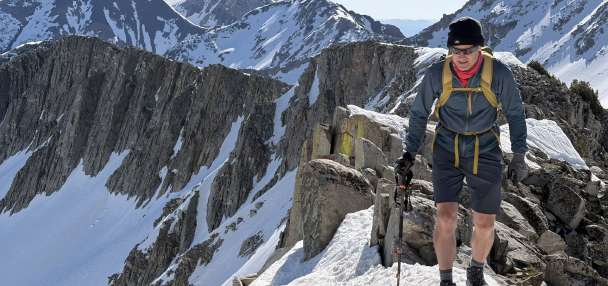
Even higher totals are expected in Utah's highest elevations, especially the mountains in southwest Utah and the Wasatch Mountains.
High temperatures are also forecast to drop over the weekend. The weather service projects high temperatures near St. George to drop from triple digits on Thursday to highs in the mid-80s over the weekend, while temperatures along the Wasatch Front may only top out in the mid-70s on Monday.
Increased flash flood risk
The forecast does indicate a higher risk of flash flooding in Utah, especially in slot canyons, dry washes and recent burn scars in areas people may flock to for the final holiday weekend of the summer.
Webber said people should look at flash flood potential forecasts before going into areas more prone to flash flooding, such as Utah's national parks, or may look to visit places with lower risks.
"All those people that people recreate at in the desert are going to see an increased risk of flash flooding through the weekend," he said, noting that earlier-than-usual heavy storms are possible Friday and Saturday. "If possible, make alternate plans and try to avoid those areas."
The return of snow?
This weekend's storm activity also has meteorologists thinking about snow for the first time since Utah's record snowpack melted in late-spring. Weather service models indicate that there is a possibility that some rain could turn into snow in parts of the state.
Webber said the low-pressure system will swing over Utah from the West either late Sunday or early Monday, causing colder temperatures in Monday's forecast. It's creating "favorable" probabilities of snow, but only in areas with "really high terrain" of about 11,000 feet elevation and above, such as the Uinta Mountains, he said.
However, don't expect much from it. Snow that does fall will likely serve more of a reminder of what is coming Utah's way in the coming months than anything else.
"It's going to be very little if any accumulation ... but it's very possible to have some flakes," he said.
Full seven-day forecasts for areas across Utah can be found online, at the KSL Weather Center.