Estimated read time: 2-3 minutes
This archived news story is available only for your personal, non-commercial use. Information in the story may be outdated or superseded by additional information. Reading or replaying the story in its archived form does not constitute a republication of the story.
OGDEN — Weber County officials are keeping a close eye on the Weber River after the National Weather Service issued a flood watch for it and two other rivers.
A tweet sent out early Sunday stated, "Three rivers remain under flood watches early this morning until further notice — The Little Bear near Paradise — the Lower Weber near Plain City — East Canyon Creek from near Jeremy Ranch to East Canyon Reservoir.
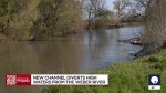
Engineers opened a new channel Saturday to prevent the Weber River from breaking its banks.
⚠️Three rivers remain under flood watches early this morning until further notice
— NWS Salt Lake City (@NWSSaltLakeCity) April 30, 2023
-The Little Bear near Paradise
-the Lower Weber near Plain City
-East Canyon Creek from near Jeremy Ranch to East Canyon Reservoir
See the graphics for more info. #utwxpic.twitter.com/6Lavr17BOr
The channel gives water managers another safe place for the water to go.
The Weber County engineer has been monitoring the snowmelt runoff for over a month.
"It's been a challenge to keep up with Mother Nature and the temperatures we have seen and still keep the water at a manageable rate," Gary Myers, the Weber County engineer said. "The Weber River broke its banks in 2011. We don't want that to happen ever again."
The Western Weber County Canal was created years ago but hasn't been used for more than just one day. A committee will oversee how long the channel will remain open. Hydrologists predict the new waterway may be needed until mid-June when the snowmelt starts to slow.
"We're trying to do the best we can to help the residents avoid disaster," Myers said.
Echo Reservoir is the first controlling structure up the Weber River. Beyond that sits Rockport Reservoir.
Experts said by the time a change is made at Echo Reservoir, that difference is not reflected in the new channel until 20 hours later.
"So we definitely have some unexpected time complications on our hands," Myers said. "We talk daily with members of the Weber Basin Water Conservancies. We also have been working with the Weber County Sheriff's Office to get a bird's-eye view from their drones. We continue to test how the area is handling the water."
🥵Our temperatures will continue to rise through the week, approaching near record highs, before cooler temperatures arrive Thursday. This will do a number on our snowpack with almost all waterways running high, fast, and cold. #utwx#wywxpic.twitter.com/nqvZlhXyhC
— NWS Salt Lake City (@NWSSaltLakeCity) April 29, 2023
The area near Warren and Plain City is mostly agricultural land with animals and farms. Many of the surrounding structures had sandbag perimeters.
"We're hoping this new waterway continues to relieve the Weber River and move this extra water to the Great Salt Lake," Myers said. "We're concerned, and we're watching it closely."
The flood watch said the river will start flooding once it reaches 27 feet along the levee system near Plain City.
At 1 a.m. Sunday, the river was at 24.5 feet according to the National Weather Service. It's expected to keep rising. The weather service predicted it would peak at 27.5 feet Tuesday evening.

Photos
Most recent Utah weather stories
Related topics
 Brittany Tait