Estimated read time: 1-2 minutes
This archived news story is available only for your personal, non-commercial use. Information in the story may be outdated or superseded by additional information. Reading or replaying the story in its archived form does not constitute a republication of the story.
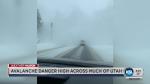
SALT LAKE CITY — A quick-moving winter storm brought a couple more inches of snow to the valleys of northern Utah on Monday — and caused some dicey driving conditions.
Traction requirements in Big Cottonwood and Little Cottonwood canyons were lifted as of 3:30 p.m., meaning that tire chains or 4-wheel drive are no longer required. Both canyons had been closed at various points Monday for avalanche control work, but were opened as of Monday afternoon.
A winter weather advisory was in effect until noon. KSL Chief Meteorologist Kevin Eubank said the recent storms have created large accumulations in the mountains, with comparatively smaller totals in the valleys. Alta Ski Area, for instance, has seen 11 inches of snow in the past 24 hours and more than 50 inches since Wednesday, but Salt Lake City has seen less than 5 inches.
Get his complete forecast at www.ksl.com/weather/forecast.
Eubank said another winter storm will hit Utah on Tuesday, starting in the north and spreading south throughout the day. He expects it will be much the same as the past week's storms, with accumulations focused in the mountains.
The Utah Department of Transportation advises that the greatest road snow impacts will likely be north of the North Salt Lake and Bountiful area. "Motorists heading up canyon and mountain routes should be prepared for chain restrictions at any time during snow events," it says.
Get traffic updates on KSL NewsRadio and at www.ksl.com/news/traffic. UDOT provides traffic updates at udottraffic.udot.gov.