Estimated read time: 2-3 minutes
This archived news story is available only for your personal, non-commercial use. Information in the story may be outdated or superseded by additional information. Reading or replaying the story in its archived form does not constitute a republication of the story.
SALT LAKE CITY — Are you dreaming of a white Christmas? You may be in luck this year, especially if you live in southern Utah. However, it also could make holiday travel a bit trickier in some places.
The National Weather Service reports a “series of storm systems” are expected to bring rain and snow across Utah beginning Monday night into Christmas Eve and through the remainder of the week.
Storm to produce southern Utah snow
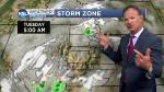
The first system is moving in from California and is expected to reach southern Utah Monday night into Tuesday, said KSL meteorologist Grant Weyman. It will bring rain and snow to the region.
“Southern mountains get the snow first; they’re going to wind up with most of the wet weather — we think — out of this next storm,” he said.
The National Weather Service issued a winter weather advisory for a good chunk of southwestern Utah, including Bryce Canyon, Loa, Panguitch and areas east of Cedar City. It goes into effect 5 p.m. Monday and runs through late Tuesday night.
Mountainous areas are forecasted to receive 7 to 14 inches from the storm.
The agency warns drivers to “plan on slippery, and at times snow-packed, road conditions over mountain routes” in the area. The roads most likely to be affected are:
- State Route 12 near Boulder Summit
- State Route 14 between Cedar City and U.S. Highway 89
- U.S. Highway 89 between Hatch and Glendale in Garfield and Kane counties
- State Routes 143 and 153 in Iron and Beaver counties
Another advisory was issued for Monticello and a swath of land north of Blanding in southeastern Utah. That advisory goes into effect noon Tuesday and will be in effect through 6 p.m. Wednesday.
The agency also advised that motorists may find hazardous weather on roadways throughout eastern Utah beginning Tuesday through the end of the week.
Rain, snow forecasted for Wasatch Front
Meanwhile, rain and snow are expected in the Wasatch Front Tuesday into Christmas Day.
“We do expect a white Christmas. It does look like some accumulation — I’d say 1 to 3 inches of snow (by Wednesday afternoon),” Weyman said.
In addition to the snow, those in the Wasatch Front are expected to receive another gift. The National Weather Service tweeted the storm system is expected to push out the latest series of inversions Monday and clear up the air for the holidays.
Forecasts for the rest of the state can be found on the KSL Weather page.