Estimated read time: 4-5 minutes
This archived news story is available only for your personal, non-commercial use. Information in the story may be outdated or superseded by additional information. Reading or replaying the story in its archived form does not constitute a republication of the story.
PARLEYS CANYON — While the first of three expected storms passed through northern Utah on Friday, police went to work cracking down on drivers traveling too fast for conditions.
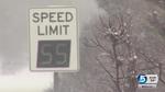
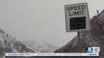
Utah Highway Patrol troopers believe there are fewer drivers going too fast through Parleys Canyon and I-80 thanks to variable speed limits in that area that are proving their worth.
As the storm blew through Parleys Canyon Friday, the Utah Department of Transportation lowered the speed limit on the digital signs from 65 mph to 45 mph.
By 6 a.m., the Utah Highway Patrol sent extra troopers to the area, anticipating slide-offs and crashes.
"The drivers were actually slowing down, and we didn't end up having a lot of crashes," said UHP Sgt. Wyatt Weber. "So without the crashes, we started enforcing that variable speed limit."
The sergeant said most motorists obeyed that lower limit, but there were some that just would not slow down. "We were seeing speeds around 65, even one up to 80 miles an hour," he said.
In a 45 mph zone, drivers were likely to get more than a warning.
"No matter what the speed limit reads, we always have to slow down and drive for the weather conditions, but in Parleys Canyon we have the benefit of adjusting the speeds," UDOT spokesman John Gleason said.
Overall, Weber said, most motorists are familiar with the signs and they make a difference. "The proof is this morning: We had very few crashes up here, drivers were doing a very good job of keeping their speed reasonable, and the results were no crashes," Weber said Friday. "I think it's been very effective."
UDOT installed the variable speed limit signs two years ago. Since then, they've lowered the speed for 239 different weather events.
"With the road snowpacked like it was and temperatures still below freezing up here, it's pretty dangerous," Weber said. "They slide out and cause a crash then everybody has to slow down for them."
Being able to adjust the speed limit on I-80 has made the roads as safe as possible, according to Gleason. Previously, it was not uncommon for weather-related crashes to close the canyon altogether.
"Since we put in the variable speed limits, we haven't had a single weather-related closure," he said.
In such circumstances, even though drivers are not traveling as fast as they normally would, there are fewer delays from crashes when everyone slows down, UDOT officials say. So motorists are often saving time by following the adjusted speed limits and going slower.
"They've been very effective. We like to have a few more years under our hat just so we can look at the data," Gleason said. "Anecdotally, it's such a benefit to have the tool to be able to adjust the speed limit and make the roads as safe as possible."
Parleys Canyon was chosen as the pilot location for the signs because of its changing weather conditions during winter months, heavy traffic and existing fiber-optic infrastructure.
The system, which includes 15 signs — eight on eastbound I-80 and seven for westbound motorists — cost $750,000.
UDOT is now considering a variable speed limit in Sardine Canyon on U.S. 89 and other high-elevation highways.
A University of Washington study found that the signs reduced the average vehicle speed by up to 13 percent in Washington and overall safety improved.
A second storm is expected to drop about 1 to 2 inches of snow in the Salt Lake Valley on Saturday, said KSL meteorologist Kevin Eubank. After a calm Sunday, a third system will drop wet snow in the northern Utah valleys Monday morning, he said.
"It might impact the holiday, but probably (won't have) the impact we'd see with our typical Monday morning commute," Eubank said.
Friday's storm brought 1 or 2 inches of snow throughout much of the Salt Lake Valley, and 2 to 4 inches throughout the foothills along the Wasatch Front, according to Eubank.
Also Friday, the National Weather Service in Salt Lake City released a water supply briefing that detailed precipitation patterns' effects on Utah over the past several months. October, November and the first half of January have been drier than usual, but heavy snowfall in December has greatly helped the state's overall snowpack, said meteorologist Brian McInerney.
Snowpack measurements compare current snow accumulation against what 30 years of climate data indicate the accumulation should be, according to Eubank. All of Utah's basins report at least 83 percent snowpack to date, while nearly all of central and southern Utah are above 100 percent.
The high figures are the result of massive snowfall in December, he said.
However, Utah will need consistently strong snowfall numbers through the winter in order to maintain encouraging snowpack measurements, McInerney said. Long-term forecasts don't predict high precipitation over the next few months, he said.
In a total reversal from January 2015, temperatures in Utah are significantly lower than average, which will help preserve the snowpack, McInerney said.
Contributing: Viviane Vo-Duc, Ben Lockhart Email: jboal@deseretnews.com