Estimated read time: 3-4 minutes
This archived news story is available only for your personal, non-commercial use. Information in the story may be outdated or superseded by additional information. Reading or replaying the story in its archived form does not constitute a republication of the story.
SALT LAKE CITY — Flash flooding swept a car off the road in Chalk Creek in Summit County on Wednesday, officials said.
The people in the car were OK, according to a tweet from North Summit Fire District officials. The flooding took place in the 1400 block of Chalk Creek Road, east of Coalville. Public works officials were responding to the scene to clear the flooded road, officials said.
The National Weather Service issued a flash flood watch for much of Utah on Wednesday.
U.S. Highway 40 was closed in both directions 4 miles west of Fruitland, near the Dollar Ridge Fire in Duchesne County, according to a tweet from Utah Department of Transportation. The road closed shortly before 5 p.m., and UDOT officials were estimating that it would take about an hour to clear it.
Flooding closed 8.6 miles of road near Diamond Fork Hot Springs in southeast Utah County, officials said.
Flooding and mud slides in Diamond Fork, Utah County. Closed during Coal Hollow Fire, then re-opened, an 8.6 mile section of Diamond Fork Rd is closed again. This time from Red Ledges picnic area to Springville Crossing is closed while Utah County Public Works clears the road. pic.twitter.com/cwqdEW3FJu
— Spencer Cannon (@SGTCannonPIO) August 23, 2018
The road was closed starting at the Red Ledges picnic area, about 7 miles east of U.S. Highway 6 on Diamond Fork Road, according to Utah County Sheriff's Office Sgt. Spencer Cannon.
The closure continued to Springville Crossing, the junction of Diamond Fork Road and Hobble Creek Canyon, Cannon said.
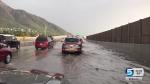
"Some flooding" was reported in the area of 2800 S. River Road in St. George, according to a tweet from the St. George Police Department. It said Horseman's Parkway and 2800 South are closed.
The waters are not receding, a foot or so below the River Road Bridge and fluctuating. Stay away from flood planes and river's edges. As interesting as these events may be, they aren't worth your life. Don't drive through areas where flooding is occurring either. pic.twitter.com/uHerd3fWZp
— St George Police (@sgcitypubsafety) August 22, 2018
ROAD CLOSURE ALERT - Roadway Flooding
— St George Police (@sgcitypubsafety) August 22, 2018
We are experiencing some flooding in the area of 2800 S River Road (Horseman's Parkway area). Horsemans Parkway and 2800 South are closed. Use Little Valley, Brigham, and Bloomington Hills as alternate routes.
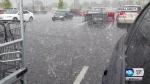
A flash flood watch was in effect from noon until 10 p.m. for much of the state, including the Wasatch Front and parts of central and southern Utah. The watch means flooding will be possible as thunderstorms develop.
The watch was lifted for much of the southern part of the state by 4:45 p.m., weather service officials said on Twitter.
We've canceled the Flash Flood Watch for our zones in southern Utah. The watch remains in effect until 9pm for the northern and central Utah areas highlighted in green on this map. #utwxpic.twitter.com/FNQK5tTUpl
— NWS Salt Lake City (@NWSSaltLakeCity) August 22, 2018
#updated_NWS_Tweet
The areas affected by the flash flood warning are highlighted in green in the above map. The areas affected by a severe thunderstorm watch are highlighted in pink. The eight largest wildfires in the state are represented in orange. Zoom in and click on the map to learn more.
Standing water on U.S. Highway 89 was affecting traffic in both directions from 500 South to 2600 South in Davis County, according to the Utah Department of Transportation. The road was expected to be cleared by 4:40 p.m.
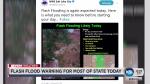
Flash Flooding is again expected today. Here is what you need to know before starting your day... #utwxpic.twitter.com/HKjgPinRUe
— NWS Salt Lake City (@NWSSaltLakeCity) August 22, 2018
The areas most prone to flash flooding include recent burn scars, slot canyons, slickrock and washes that are normally dry, the weather service stated on Twitter.
In Salt Lake City, a flash flood warning was in effect until 5 p.m. in the area north of the state Capitol where the Columbus Fire burn scar is located.
This Flash Flood Warning is for the Columbus burn scar, located just north of the Capitol Building. Homes just below the burned area are expected to receive muddy flows into the neighborhood. #utwxhttps://t.co/JZUIdL9Jpz
— NWS Salt Lake City (@NWSSaltLakeCity) August 22, 2018
#NWS_tweet_Columbus
A flash flood warning for southeastern Washington County and western Kane County, including Zion National Park, expired at 6:45 a.m.
The National Weather Service issued a severe thunderstorm warning for Clearfield and Layton in Davis County and for Roy in Weber County until 3 p.m.
Severe Thunderstorm Warning including Layton UT, Roy UT, Clearfield UT until 3:00 PM MDT pic.twitter.com/tPmSR1oimY
— NWS Salt Lake City (@NWSSaltLakeCity) August 22, 2018
#NWS_tweet
In Lofgreen, Silver City, Henefer, Emery and the Devil's Slide area, a severe thunderstorm warning was expected to last until 2:45 p.m.
Farmington, Fruit Heights and Kaysville were also under a severe thunderstorm warning earlier in the day.
Weather officials also issued a severe thunderstorm warning for parts of northern Utah near Snowville until 9 a.m. Wednesday and then extended the warning until 10 a.m.
Severe Thunderstorm Warning including Newton UT, Riverside UT, Clarkston UT until 10:00 AM MDT pic.twitter.com/BLJzbNvuDg
— NWS Salt Lake City (@NWSSaltLakeCity) August 22, 2018
Get the complete forecast at the KSL weather page.
Editor's note: A previous version of this article erroneously said the flash flood watch was in effect until noon.
Contributing: Jacob Klopfenstein