Estimated read time: 2-3 minutes
This archived news story is available only for your personal, non-commercial use. Information in the story may be outdated or superseded by additional information. Reading or replaying the story in its archived form does not constitute a republication of the story.
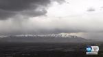
SALT LAKE CITY — Snowpack in Utah’s mountains typically peaks around April 1, before the beginning of spring runoff. While snowpack is way below normal, Utah’s water reserves are not in bad shape. A hydrologist says it’s too late to catch up on mountain snowpack, but stored water will get Utah through the summer.
“The story for 2018 is really one of really poor runoff, really poor snowpack, but really good reservoir storage,” said Brian McInerney, a hydrologist with the National Weather Service in Salt Lake City.
After a wet March, Utah could really use a cool, wet spring to offset the dismal snowpack, he said. Most of the low and mid-elevation snowpack is already melting, starting to flow in low elevation streams, like Emigration Creek, 10 days earlier than normal.
“Statistically, the first week of April has the largest snowpack in Utah,” said McInerney.
Even after a winter like this one, which was unseasonably warm and dry with the exception of a wet four weeks from February into March, “Our snowpack is really quite low,” he said.
McInerney says below 7,000 feet, and on south-facing slopes, the snowpack is nearly nonexistent.
“We’ve been melting low elevation snow starting in January and February, incredibly early.”
Throughout most of the state, snowpack is just 50 to 60 percent of normal. It’s even lower in southeastern Utah, and 80 percent of normal in extreme northern Utah.
“What would it take to get us back to average conditions?” McInerney asks hypothetically. “It’s about 7 inches of water.”
“The story for 2018 is really one of really poor runoff, really poor snowpack, but really good reservoir storage.” - Brian McInerney, National Weather Service
Roughly, seven major snowstorms to deliver the water to bring Utah snowpack back to normal this late in the snow season.
“We’d be doing much better off,” he said, “But, we’re not.”
Fortunately, Utah’s reservoirs captured near-record runoff from last year’s snowpack, otherwise some communities in our state would face water shortages.
“Last year, we had about 150 to 200 percent volume of runoff into the reservoirs, and we filled almost all of the reservoirs.”
The hydrologist believes that’s why northern Utah reservoirs will refill again this year. Bear Lake will even come close to full pool, he said, but not reach capacity. That’s a direct result from the recharge that all of Utah’s reservoirs got last spring.
Two years ago, reservoir storage statewide was roughly 30 percent. This year reservoir storage is at 80 percent in northern Utah following the carryover from last year.

“Even though we’re going to get a very anemic runoff this year, our water supply is actually in quite good shape,” he said.
Cool, wet days like Monday are much better for Utah runoff, McInerney tells me. Cool weather helps stall the inevitable draw down on the water reserves during the heat of the summer.
“After that, we will see how it goes,” McInerney said. “The longer you can delay runoff, the better yield you get, the more efficient runoff. That’s what we’re shooting for right now.”


