Estimated read time: 3-4 minutes
This archived news story is available only for your personal, non-commercial use. Information in the story may be outdated or superseded by additional information. Reading or replaying the story in its archived form does not constitute a republication of the story.
PROVO — A BYU professor has cataloged more than 13,000 dams in the U.S. to create a database that will aid in water safety and prevent drownings.
Civil engineering professor Rollin Hotchkiss created a national task force to build a nationwide database on low-head dams.
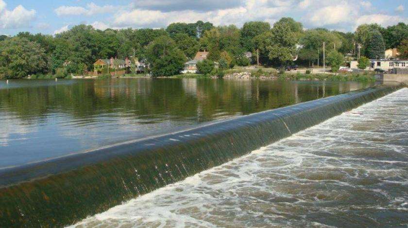
These dams are man-made barriers that change the level of a river and can be anywhere from 1 to 15 feet tall. The dams maintain steady water levels so water can be diverted for power production, storage or irrigation.
Low-head dams are difficult to see from upstream because they typically extend the width of the waterway, causing the horizon to appear uninterrupted. People who go over the dams can get trapped underwater at the base due to strong currents coming off the dam.
"More people have drowned at low-head dams in the last 50 years than from all the large dam failures in the same period," Hotchkiss said. "Low-head dams can be extremely dangerous, and they rarely get inspected or updated."
A press release from BYU said about 25% of deaths at low-head dams occur when people attempt to rescue someone and underestimate the current.
In his research, Hotchkiss found that more than 1,000 people in the U.S. drowned because of a low-head dam. This prompted Hotchkiss to devise a way to prevent future tragedies, and finding out where the dangerous dams are located was the first step.
"The heart-rending stories of families impacted by drownings at low-head dams motivated me to do something to help," Hotchkiss said. "It doesn't have to happen."
Compiling the database took three years and was a complex process due to low-head dams often being "orphaned," Hotchkiss said. Many of them are no longer being maintained so it can be difficult to determine who owned it and has responsibility over it.
A subcommittee of the task force reached out to state governments for records of dam locations but only a dozen states had lists. So Hotchkiss recruited students to canvas Google Earth Pro where they searched for white lines across rivers and streams — a "tell-tale" sign of the whitewater at the base of low-head dams.
Hotchkiss then enlisted the help of a U.S. Army Corps engineer who reviewed all of the potential dams marked by students.
"This is the opportunity that students long to have: being able to contribute to a meaningful project and leave an impact," civil engineering student Easton Cluff said. "The Army Corps of Engineers will be using our beta catalog of low-head dams for years to come."
Hotckiss' task force also collaborated with Southeast Aquatic Resources Partnership, which shared research on water obstructions. The organization gave thousands of new locations for students to research and verify.
Hotchkiss and his team presented the database of 13,000 low-head dams at the Dam Safety Conference of the Association of State Dam Safety Officials in September.
"This database couldn't have been created without a lot of peoples' help and goodwill," Hotchkiss said. "We know there are more low-head dams, but this is a great place to start."
Hotchkiss also created an inventory of fatalities that have occurred at low-head dams and suggested multiple designs that could potentially reduce dangerous current strength.

Photos
Most recent Environment stories
Related topics
 Cassidy Wixom