Estimated read time: 6-7 minutes
This archived news story is available only for your personal, non-commercial use. Information in the story may be outdated or superseded by additional information. Reading or replaying the story in its archived form does not constitute a republication of the story.
SALT LAKE CITY — The new year continues what the end of 2022 brought to many Utahns — snow and car crashes.
Northern Utah woke up to several inches of snow and a winter storm warning for much of the Wasatch Front. And the snow just kept coming.
"Alta's had 22 inches in the last 24 hours; Snowbird 21 (inches); Deer Valley 18 (inches)," KSL meteorologist Kevin Eubank said Sunday afternoon. "Daybreak 10 to 12 (inches) depending on where you are. South Jordan has had 9 (inches). Herriman has had 7 (inches), and Sandy has picked up 5 inches."
Eubank said snow was expected to continue through the night and into Monday morning across northern Utah and in Utah's mountains. The forecast calls for the following snow totals in addition to what's already fallen:
- Salt Lake City: 2-4 inches
- Tooele Valley: 3 inches
- Alta: 2 inches
- Uintah Mountains: 10 inches
- Brianhead: 8 inches
- I-15 corridor, from Cedar City to Fillmore: 3 inches
More snow is expected along the Wasatch Front Monday afternoon with additional snow Monday night, but that should be light snow, perhaps 1 or 2 inches.
Monica Traphagan, senior meteorologist with the National Weather Service, said the heavy rain over much of the state has caused some issues in southern Utah's canyons and creeks.
She said rangers at Zion National Park reported flash floods in the morning, and in the afternoon reported the issues were still ongoing. She said a fire chief who happened to be visiting Snow Canyon said a creek was overflowing onto the roadway and the south entrance of the park was closed in response to the impassable road.
The roads
Utah Highway Patrol Sgt. Cam Roden said there were 450 car crashes from Friday to Sunday and about another 133 crashes by Monday afternoon.
UHP Sgt. Brian Peterson cautioned drivers about the slick conditions and told Utahns to take it slow Sunday. He said speed was the top cause of crashes during slick conditions.
Peterson said the posted speed limits are for ideal conditions, and drivers should slow down for wet, slushy and icy roads.
He encouraged drivers to increase their following distance, be aware of extra time needed to stop, not use cruise control, wear seat belts, stay behind snow plows and be alert.
If you begin to skid, steer into the slide, avoid unnecessary breaking and don't panic, which can lead to an overcorrection. Peterson said if you are involved in a crash, you should move to the right and stay in the car where you are more protected from other vehicles sliding in the same area.
He said over the holiday weekend there had been at least 193 crashes as of Sunday afternoon, some of which could be attributed to the weather, and 31 instances of driving under the influence.
John Gleason, spokesman for the Utah Department of Transportation, said plows are out dealing with thick heavy snow — a snow that was expected. He said Sunday is not a great day for traveling, and he hopes with the holiday there will be fewer cars on the road.
Avalanche danger
By mid-morning, skiers were waiting to drive up Little Cottonwood Canyon. The canyon road was closed as UDOT conducted avalanche mitigation.
🚧#RoadClosureUpdate🚧
— UDOT Cottonwood Canyons (@UDOTcottonwoods) January 1, 2023
👋 LCC travelers, #SR210 still CLOSED. @UDOTavy avalanche mitigation is ongoing. Please be patient while road & avalanche crews work.
No estimated opening time - update provided when known.@UDOTTRAFFIC@AltaCentral@AltaAlerts@SnowbirdAlerts@UPDSLpic.twitter.com/esnJarpVpX
He said everything has been going well so far as they work to control avalanches in Little Cottonwood Canyon.
It's been an incredible weekend for Utah ski resorts, with all resorts reporting new snow. Overnight at Brighton, the resort got 20 inches of new snow. The new snow has UDOT conducting avalanche mitigation in Little Cottonwood Canyon.
The Utah Avalanche Center reports high avalanche danger rates for much of the state, and Provo currently has an extreme danger rating.
Happy New Year. Avalanche Warning and HIGH danger continues for much of the state. Get the forecast. https://t.co/T3rY14Oc1Opic.twitter.com/mORoWPCNLx
— UtahAvalancheCenter (@UACwasatch) January 1, 2023
Drew Hardesty, forecaster with the Utah Avalanche Center, said natural avalanches are running and cautioned people to avoid traveling beneath large avalanche paths. The wet, heavy snow makes the avalanche danger even worse. Hardesty said there have been dozens and dozens of avalanches on Sunday morning, some controlled and some not.
On northwest- to east-facing slopes, Hardesty said avalanches could reach down into weaker layers leading to very destructive avalanches.
"Travel in avalanche terrain is not recommended today," he said.
Hardesty said there are places people can go recreate with no danger of avalanches, noting some trailheads in the Cottonwoods and Millcreek canyons are not avalanche terrain — but he said people need to be cautious of the slopes they are on and what is on top of them.
He said a few times each winter the avalanche danger gets to the point that it is at today, but the danger in Provo is even rarer.
"That amount of snow and rain is unbelievable, to put it very lightly," Hardesty said.
He said the storm had already dropped 2 feet of snow in the upper Cottonwood canyons, about 1.5 feet in Park City and about 3.5 feet in the Provo-area mountains, which is about 8 inches of snow water.
Hardesty said snow is expected to continue throughout the day and into Sunday night — bringing another 12-18 inches of snow in the mountains before the storm is over.
As the storm continues, Hardesty said the avalanche danger will stay high likely into Monday or Tuesday, but the long-term outlook is very good. He said with the amount of snow in the mountains things will stabilize quickly and remain stable until the next series of storms comes.
He said information from the public about avalanches is "like gold." Although the first priority is to stay safe, he said if you are in a good spot and see an avalanche, taking a picture and submitting it on their website with information about where you were can help them have a better idea of conditions and helps to save lives.
Wet, heavy snow affects utilities
Dave Esckelsen with Rocky Mountain Power said heavy wet storms can lead to power outages, and there are quite a few accompanying this storm.
Along the Wasatch Front Sunday morning, about 600 people were without power, but Esckelsen said the biggest outage so far was at 1:25 a.m. and it lasted 9 minutes and affected 2,700 customers throughout the Kamas area.
"It was just the snow unloading from the lines," Esckelsen said.
There was also a pole that was down in Kamas Sunday morning and outages now are from trees or snow disturbing the line.
Esckelsen said they had people prepared to respond to this, and as snow continues to accumulate more outages may come.
"We're working on them, and we'll get to everybody as soon as we can," he said.
Draper City reported Saturday night that a break in a water line led them to take crews away from driving snow plows to work on fixing the water line. A Facebook post asked for patience in the morning while additional staff becomes available.
The water service was back online around 3:00 a.m. and Linda Peterson with Draper City said the plow truck routes were covered again.
She said since there have been so many storms, many people on their crews had already reached their max hours so they did not have people to call in when an additional issue arose. She said snow plow crews are staffed by other public works employees.
"Gratefully, the water's back and everybody's driving again," Peterson said.
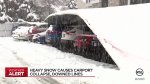
In West Jordan, a carport collapsed after holding the heavy snow longer than it could handle. Battalion Chief Jared Price, with West Jordan Fire Department, said it was a corrugated aluminum carport that collapsed on 14 vehicles. Of those, 11 appeared to be damaged.
Contributing: Jordan Ormond