'%3e%3cpath%20d='M34.1406%205.85938C30.3906%202.10547%2025.3047%200%2020%200C14.6953%200%209.60938%202.10547%205.85938%205.85938C2.10938%209.61328%200%2014.6953%200%2020C0%2025.3047%202.10547%2030.3906%205.85938%2034.1406C9.61328%2037.8906%2014.6953%2040%2020%2040C25.3047%2040%2030.3906%2037.8945%2034.1406%2034.1406C37.8906%2030.3906%2040%2025.3047%2040%2020C40%2014.6953%2037.8945%209.60938%2034.1406%205.85938ZM37.0117%2023.543H31.1602V13.5391H27.6328V19.9414C28.1211%2020.6914%2028.3711%2021.582%2028.3711%2022.5625V22.625C28.3711%2023.668%2028.1172%2024.6055%2027.6328%2025.4297V26.6094H36.082C33.4883%2032.9375%2027.2891%2037.3789%2020.0039%2037.3789C10.3711%2037.3789%202.62109%2029.6289%202.62109%2020C2.62109%2010.3711%2010.3711%202.62109%2020%202.62109C29.6289%202.62109%2037.3789%2010.3711%2037.3789%2020C37.3789%2021.1484%2037.2617%2022.2656%2037.0508%2023.3477C37.0391%2023.4141%2037.0234%2023.4766%2037.0117%2023.543Z'%20fill='white'/%3e%3cpath%20d='M22.3086%2018.5352C20.4336%2018.125%2019.9531%2017.8398%2019.9766%2017.1836V17.1406C19.9766%2016.6992%2020.3477%2016.2148%2021.4023%2016.2148C22.582%2016.2148%2023.8867%2016.6797%2025.0781%2017.4766L26.8516%2015.0195C25.4453%2013.8906%2023.707%2013.3398%2021.5547%2013.3398C18.5195%2013.3398%2016.4375%2015%2016.4063%2017.4766V17.5352C16.3633%2020.2617%2018.5859%2020.9805%2021.293%2021.6016C23.0391%2021.9766%2023.5703%2022.3164%2023.5703%2022.9609L23.5469%2022.9766C23.5469%2023.3906%2023.2578%2023.7031%2022.7852%2023.8359C22.5742%2023.9062%2022.1289%2023.9727%2021.5156%2023.9727C20.7617%2023.9727%2019.7539%2023.8633%2018.6328%2023.4844C18.0898%2023.2891%2017.4727%2023.0039%2016.8047%2022.6133L20.1406%2026.625C20.2813%2026.6602%2021.0977%2026.8516%2021.7734%2026.8516C25.0039%2026.8516%2027.0859%2025.2461%2027.1094%2022.6328V22.5703C27.1602%2020.1133%2025.2148%2019.1719%2022.3086%2018.5352Z'%20fill='white'/%3e%3cpath%20d='M5.24219%2013.5664V26.6133H8.75391V23.7578L10.2969%2021.9531L14.2031%2026.6133H18.3867L12.3555%2019.5195L17.4023%2013.5664H13.4531L8.75391%2019.0586V13.5664H5.24219Z'%20fill='white'/%3e%3c/g%3e%3cdefs%3e%3cclipPath%20id='clip0_97_2430'%3e%3crect%20width='40'%20height='40'%20fill='white'/%3e%3c/clipPath%3e%3c/defs%3e%3c/svg%3e)


Estimated read time: 4-5 minutes
This archived news story is available only for your personal, non-commercial use. Information in the story may be outdated or superseded by additional information. Reading or replaying the story in its archived form does not constitute a republication of the story.
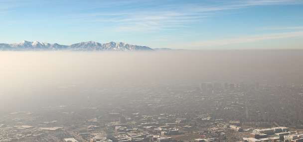
SALT LAKE CITY — Monsoonal moisture raised dewpoint levels to about 65 degrees along the Wasatch Front on Tuesday, causing National Weather Service meteorologists to make an unusual weather comparison: the East Coast's hot, humid summers.
"It's not often you can use the word 'muggy' in reference to Utah but here we are," the agency tweeted.
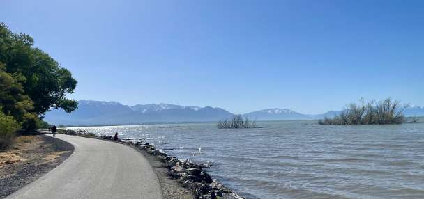
That also means Utah is getting precipitation, which is sorely needed because the state entered the second half of the year on pace for its third-driest year on record.
And more rain is on the way.
The weather service adds that another "monsoonal moisture surge" is headed to Utah, developing late Wednesday and continuing at times through the weekend. That is good for the soil moisture levels and reduced fire risks, but it will also come with increased risks of more flash flooding.
"Moisture will begin to increase across central and south Utah, increasing the probability of locally heavy rainfall," the agency noted Tuesday, adding that all parts of Utah will ultimately be affected during the second half of the week.
KSL meteorologist Matt Johnson explains that the next wave is fueled by the same pattern that brought moisture throughout the state the past few days. A high-pressure system positioned over the Four Corners region is helping pump moisture from the Gulf of Mexico north toward Utah.
"We're starting to turn on that little flow, that nozzle from the Gulf of Mexico," he said.
⛈ Yet another monsoonal moisture surge is on the way for our area beginning late Wednesday. Be sure to monitor the forecast, as flash flooding is a potential hazard in prone areas. #utwx#wywxpic.twitter.com/swkk1HinuT
— NWS Salt Lake City (@NWSSaltLakeCity) August 2, 2022
A National Oceanic and Atmospheric Administration model for the first week of August projects upwards of an inch of rain across central Utah, while all other parts either have already or will receive some sort of rain this week.
The monsoonal impact
About 84% of Utah remains in at least extreme drought, but this summer's monsoonal storms are slowly starting to make an impact on the state. Utah Division of Water Resources officials reported last week that storms have helped soil moisture levels reach closer to normal and even above normal in some places. As of Tuesday afternoon, levels ranged anywhere from 87% to 104% of normal across the state, according to National Water and Climate Center data.
It's also reducing fire risks in the state, according to a monthly update by the Great Basin Predictive Services. Basil Newmerzhycky, a lead meteorologist for the agency, said in a video posted Monday that the moisture content of dead fuels in the state has improved favorably across Utah over the past month, especially in southern Utah. The levels are still dry for most of the state but no longer in the most severe categories as some parts were.
The wet start to August is only helping conditions improve.
"That's going to be able to take a big chunk out of the fire danger, in terms of moistening up the fuels," he said, adding that eight- to 14-day outlooks indicate a high likelihood that monsoon moisture patterns will continue across the West into the second week of August.
The Great Basin Predictive Services updated its August fire outlook Monday to list all of the Great Basin region as normal fire risks. That includes most of Utah and Nevada, as well as parts of Idaho and Wyoming, though Newmerzhycky said conditions can quickly dry up in wildland areas if the rain stops.
Meanwhile, the storms are also helping fill some gaps in this year's precipitation normals. For example, the weather service's Cooperative Observer Program site in St. George received 1.03 inches of rain in July, which is nearly a tenth of an inch more than it had received from the first half of the calendar year combined.
Salt Lake City received 0.43 inches of rain from storms on Monday and early Tuesday, which is more than three times the amount Utah's capital city received throughout all of July. The city does remain 2.24 inches below normal for the water year, which began on Oct. 1, 2021, and 3.93 inches below normal this calendar year, though.
The moisture also snapped the city's streak of reaching at least 90 degrees at 41 days, nine shy of the all-time record.
The storms that arrived in northern Utah on Monday even dropped close to 2 inches of rain over south Tremonton.
Full seven-day forecasts for areas across Utah can be found online at the KSL Weather Center.