'%3e%3cpath%20d='M34.1406%205.85938C30.3906%202.10547%2025.3047%200%2020%200C14.6953%200%209.60938%202.10547%205.85938%205.85938C2.10938%209.61328%200%2014.6953%200%2020C0%2025.3047%202.10547%2030.3906%205.85938%2034.1406C9.61328%2037.8906%2014.6953%2040%2020%2040C25.3047%2040%2030.3906%2037.8945%2034.1406%2034.1406C37.8906%2030.3906%2040%2025.3047%2040%2020C40%2014.6953%2037.8945%209.60938%2034.1406%205.85938ZM37.0117%2023.543H31.1602V13.5391H27.6328V19.9414C28.1211%2020.6914%2028.3711%2021.582%2028.3711%2022.5625V22.625C28.3711%2023.668%2028.1172%2024.6055%2027.6328%2025.4297V26.6094H36.082C33.4883%2032.9375%2027.2891%2037.3789%2020.0039%2037.3789C10.3711%2037.3789%202.62109%2029.6289%202.62109%2020C2.62109%2010.3711%2010.3711%202.62109%2020%202.62109C29.6289%202.62109%2037.3789%2010.3711%2037.3789%2020C37.3789%2021.1484%2037.2617%2022.2656%2037.0508%2023.3477C37.0391%2023.4141%2037.0234%2023.4766%2037.0117%2023.543Z'%20fill='white'/%3e%3cpath%20d='M22.3086%2018.5352C20.4336%2018.125%2019.9531%2017.8398%2019.9766%2017.1836V17.1406C19.9766%2016.6992%2020.3477%2016.2148%2021.4023%2016.2148C22.582%2016.2148%2023.8867%2016.6797%2025.0781%2017.4766L26.8516%2015.0195C25.4453%2013.8906%2023.707%2013.3398%2021.5547%2013.3398C18.5195%2013.3398%2016.4375%2015%2016.4063%2017.4766V17.5352C16.3633%2020.2617%2018.5859%2020.9805%2021.293%2021.6016C23.0391%2021.9766%2023.5703%2022.3164%2023.5703%2022.9609L23.5469%2022.9766C23.5469%2023.3906%2023.2578%2023.7031%2022.7852%2023.8359C22.5742%2023.9062%2022.1289%2023.9727%2021.5156%2023.9727C20.7617%2023.9727%2019.7539%2023.8633%2018.6328%2023.4844C18.0898%2023.2891%2017.4727%2023.0039%2016.8047%2022.6133L20.1406%2026.625C20.2813%2026.6602%2021.0977%2026.8516%2021.7734%2026.8516C25.0039%2026.8516%2027.0859%2025.2461%2027.1094%2022.6328V22.5703C27.1602%2020.1133%2025.2148%2019.1719%2022.3086%2018.5352Z'%20fill='white'/%3e%3cpath%20d='M5.24219%2013.5664V26.6133H8.75391V23.7578L10.2969%2021.9531L14.2031%2026.6133H18.3867L12.3555%2019.5195L17.4023%2013.5664H13.4531L8.75391%2019.0586V13.5664H5.24219Z'%20fill='white'/%3e%3c/g%3e%3cdefs%3e%3cclipPath%20id='clip0_97_2430'%3e%3crect%20width='40'%20height='40'%20fill='white'/%3e%3c/clipPath%3e%3c/defs%3e%3c/svg%3e)


Estimated read time: 5-6 minutes
This archived news story is available only for your personal, non-commercial use. Information in the story may be outdated or superseded by additional information. Reading or replaying the story in its archived form does not constitute a republication of the story.
SALT LAKE CITY — Happy meteorological spring!
While vernal equinox isn't until March 20, Tuesday marks the first day of spring from a meteorological standpoint. It means temperatures are slowly rising as winter comes to a close.
Spring also plays an important role in Utah's water supply. With a 20th Century average of 3.73 inches statewide, spring is historically Utah's wettest season, according to data compiled by the National Centers for Environmental Information.
The season includes the final few weeks of snow collection, and also how that snow ends up in reservoirs. Snowpack accounts for roughly 95% of the state's water supply. Utah's snowpack is currently at 82% of normal, which means this spring will be important in Gov. Spencer Cox's hope for normal snowmelt to help refill the state's reservoirs.
So will Utah hit 100%?
The National Weather Service Climate Prediction Center's outlook for the next week looks promising in terms of precipitation, but its cumulative outlook for the spring months of March, April and May is less optimistic. It calls for warmer and drier conditions than historic averages. That doesn't mean there won't be storms or cool days, it just won't be as cool and wet as it should be during a vital time in the snow cycle.
"Right now, the odds are tilted toward above-normal temperatures and below-normal precipitation," said Christine Kruse, lead meteorologist at the National Weather Service's Salt Lake City office.
Storms to start spring, then it dries out
This spring is forecast to start off pretty well in Utah. The prediction center looks at various atmospheric patterns and then posts long-range forecasts for different time intervals — such as 8-to-14 day, one-month and three-month outlooks — based on what's expected with those patterns, Kruse explained.
Kruse said Utah will continue to experience warm and dry conditions through late Thursday or even into Friday before there's a "pretty significant pattern change" that will produce colder and wetter weather and "multiple storms" passing through the state.
"Right now our confidence in any particular storm having a lot of precipitation is low, but we will see a series of storms into next week," she said. "Our chances for precipitation are definitely increased this weekend into earlier next week."
Things begin to change for the second half of March, according to the series of outlooks. Parts of northern Utah are listed as having above-average probabilities for precipitation while some parts of southeastern Utah have a higher probability of drier-than-average conditions. The rest of Utah is listed as in "equal chances," meaning there are really no indications either way.
In fact, the entire March outlook — taking in the first and second half of the month — lists almost all of Utah with "equal chances" in terms of precipitation. It lists most of Utah as having a higher probability for colder-than-average temperatures.
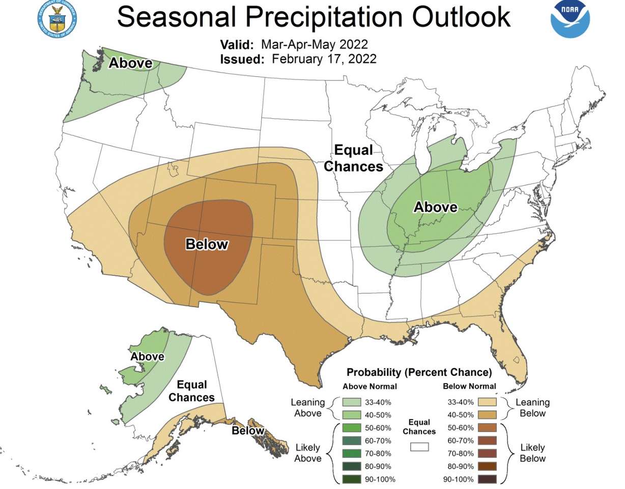
The three-month outlook shows almost all parts of Utah as having drier-than-average conditions when lumping the months of March, April and May together. Southeast Utah has the strongest odds at 50-60%, while the rest — aside from a sliver of northwestern Utah, which is in "equal chances" — falls between 33-50%.
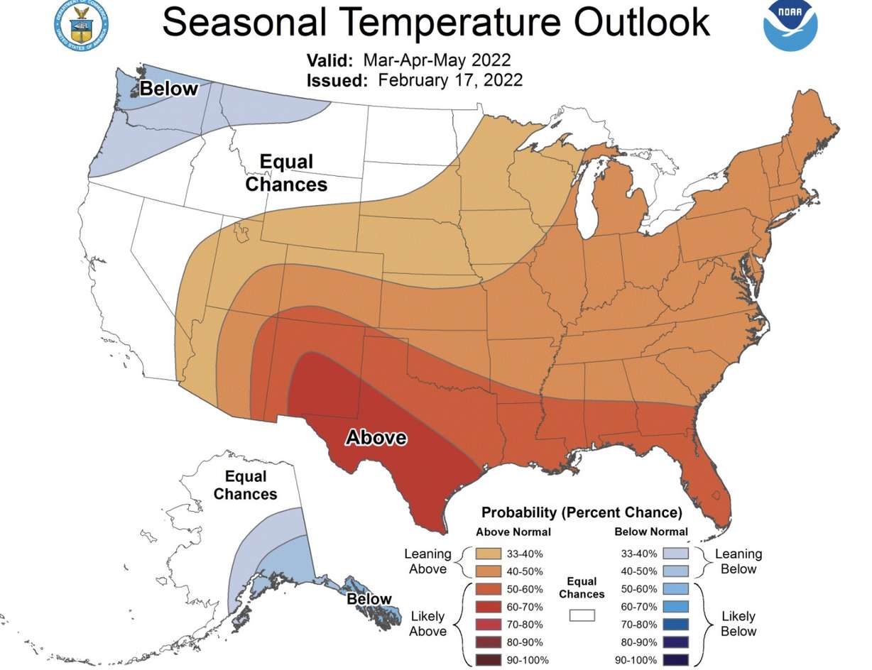
The same goes for temperatures, where southeast Utah has a 40-50% probability of above-average temperatures for the entire season, while most of the rest of the state is listed within 33-40%. The sliver of northwest Utah is also listed as having "equal chances" regarding temperature.
But that does come with an important caveat. Kruse points out this doesn't mean Utah won't receive storms in March, April and May.
"(It's) more of a general, probabilistic look at what the season might look like," she said.
That means Utah can continue to tack on much-needed precipitation throughout the season — it just may not be as much as the average in history. It's still difficult to know if Utah will hit that 100% snowpack.
"I think we need to be in a 'wait and see' (mindset) and see if we get storms that keep bringing precipitation to our mountains," Kruse adds.
Snowmelt outlook
Spring conditions aren't just important for snowpack collection but also how that snowpack ends up in reservoirs. Utah's snowpack collection typically peaks on April 4, per Natural Resources Conservation Service data. That's when all the snow in the mountains melts into rivers and streams, which then flows into lakes and reservoirs.
The state's entire reservoir system was listed at about 54% on Feb. 10. It fell below 50% at times last year due to Utah's drought.
If snowmelt began today, there would be 10.1 inches of water coming from the mountains into those reservoirs. That figure is close to two-thirds of the normal spring runoff, or 71% of the normal peak from the past 30 years, according to the data.
But Kruse says spring precipitation and temperatures actually play vital roles in how runoff occurs. Soil moisture levels and how fast Utah warms up in the spring are among the different factors that determine how efficient the snowmelt is.
Since soil moisture levels were at record lows last spring, the 2021 snowmelt ended up going into the ground to recharge groundwater levels instead of going into reservoirs. It's why reservoirs fell below 50% by the end of the 2021 water year.
Since the start of the 2022 water year in October was much wetter, Utah's soil moisture levels are closer to normal this spring. So no matter how much Utah collects in terms of snowpack, it's much more likely to go into the reservoirs than last year.
"The one thing I can say is I think it will be more efficient," Kruse said. "We're starting off in a better place where we can see a more efficient runoff."
That runoff will determine how full Utah's reservoirs will be for the rest of the year.