Estimated read time: 4-5 minutes
This archived news story is available only for your personal, non-commercial use. Information in the story may be outdated or superseded by additional information. Reading or replaying the story in its archived form does not constitute a republication of the story.
SALT LAKE CITY — The National Weather Service's Climate Prediction Center on Thursday issued a La Nina watch, reporting that trends show the oceanic event emerging between September and November with a 66% probability that it'll last through the winter.
La Nina is the result of stronger Pacific trade winds that typically flow from South America west toward Asia. It pushes warm ocean water westward with it, unlike its counterpart El Nino. This allows cooler oceanic water to rebuild off the western coast of South America, according to the National Ocean Service, which is a division of the National Oceanic and Atmospheric Administration.
This matters because ocean trends impact weather patterns across the U.S.
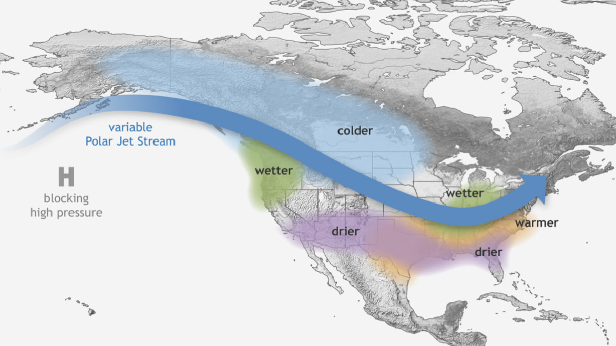
Based on an average of previous La Nina winters, La Nina patterns result in a polar jet stream pattern that provides wetter conditions in the Pacific Northwest and Great Lakes regions, as well colder air across the northern parts of the West and Midwest. It also results in warmer conditions across the southeast and drier conditions across the Southwest and Southeast.
It differs from El Nino in that conditions during El Nino are generally wetter and colder across the southern parts of the U.S. as a result of an extended Pacific jet stream. It typically results in warmer conditions across the northern United States and Canada, as well as drier conditions in the Midwest.
Interestingly enough, neither pattern results in defined weather trends for most of Utah — at least historically speaking. What that means is that it's difficult to tell if Utah is headed into a wet, dry, warm or cold winter.
"Our signal is not very strong," said Christine Kruse, lead meteorologist with the National Weather Service's Salt Lake City office. "There are some La Ninas where we might see heavier-than-normal (precipitation), some average, some below normal. It just doesn't have any consistency because of the way the jet stream sets up with a typical La Nina."
A typical La Nina could have more of a negative impact on the southern tip of Utah, like St. George. The area is located just on the northern edge of where drier conditions normally emerge from the average polar jet stream.
Again, that dry area is based on the average La Nina winter. Where the jet stream sets up will ultimately determine if Utah is headed for a desired wet and cold winter or a feared hot and dry one based on the ongoing drought.
It also means meteorologists will have to wait for the jet stream to set up before they have a better picture of what to expect this winter. Cruse said that typically starts to develop in the fall near the same timeframe of September to November, when the prediction center expected the La Nina to set up.
"(The jet stream) can change. You can start one part of the winter with one particular storm track and an upper-level ridge develops in a new location and things change," she said. "But you start to see somewhat of what the winter may look like by late fall to early winter."
The Climate Prediction Center typically releases its outlook for the winter months beginning around mid-October.
This winter is already pegged by state water experts as an important one because of the statewide drought. The U.S. DroughtwMonitor currently lists about 98% of Utah in at least an extreme drought and nearly two-thirds in an exceptional drought.
A vast majority of Utah's water comes from snowpack during the winter, so experts say a strong winter is what's needed to help pull the state out of the drought.
On a more regional scale, a La Nina event does figure to be welcome news for parts of the West, which is dry throughout. The U.S. Drought Monitor also lists 93.7% of the entire region — a collection of Utah, Arizona, California, Idaho, Montana, Nevada, New Mexico, Oregon and Washington — is in at least a moderate drought.
Nearly 60% of the West is considered in an extreme drought and a little more than a quarter of the region is in exceptional drought. Many parts of the Pacific Northwest, where a La Nina winter generally produces more rain, are currently in those more severe categories.
Conversely, a normal La Nina is potentially more bad news for the areas of the Southwest like Arizona and New Mexico, which are also covered by some of the most severe drought categories.


