Estimated read time: 2-3 minutes
This archived news story is available only for your personal, non-commercial use. Information in the story may be outdated or superseded by additional information. Reading or replaying the story in its archived form does not constitute a republication of the story.
SALT LAKE CITY — Talk about a cool down. Well, for now at least.
Following a patch of record heat that Utah experienced last weekend, which then carried over into well-above-average temperatures this week, the National Weather Service meteorologists are now advising Utahns, especially residents in higher-elevation communities, to consider covering plants because of the potential for patchy frost that could develop Friday morning.
The cooldown is the result of a cold front sweeping across the state Thursday, dropping high temperatures from the 90s down to the 70s around the Wasatch Front. Highs around St. George were expected to top out in the mid-80s Thursday.
"It's a big drop, almost a 20-degree difference from (Wednesday)," said KSL meteorologist Grant Weyman.
In addition to cooling temperatures, the cold front also has picked up winds across the state. Weyman said gusts are expected to range from 25 mph to 35 mph from Logan through Provo, as well as exceed 40 mph across eastern Utah. Southwest Utah will also experience wind gusts ranging from 20 mph to 30 mph.
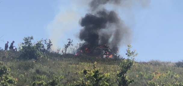
The wind poses challenges for crews battling wildfires across the state. Aside from the Wasatch Backcountry and High Uintas, the National Weather Service issued a red flag warning for all of Utah Thursday due to the strong wind gusts and low relative humidity.
The cooldown during the day will carry overnight. The National Weather Service forecast calls for overnight lows from Thursday to Friday to reach the 30s in Logan, Delta and Milford, with some communities in Utah possibly reaching the freezing point.
The weather service tweeted that residents in the Cache Valley, Bear River Valley, as well as high-elevation areas in southern and central Utah should consider covering their plants due to the possible threat of patchy frost.
The cooler temperatures aren't expected to last very long, however. High temperatures are expected to return back to the upper 90s in the Wasatch Front by the weekend and even return to 100 degrees by the start of the next week.
High temperatures are also expected to return to triple digits in St. George by Saturday before nearing 110 degrees for the next week.
Full forecasts for areas across Utah can be found at the KSL Weather Center.