Estimated read time: 2-3 minutes
This archived news story is available only for your personal, non-commercial use. Information in the story may be outdated or superseded by additional information. Reading or replaying the story in its archived form does not constitute a republication of the story.
SALT LAKE CITY — Another round of snow made its way through Utah on Sunday.
People should be prepared for heavy snow, poor visibility and deteriorating road conditions as a storm system moves from north to south across the state, according to a tweet from the National Weather Service in Salt Lake City.
KSL Weather's Brett Benson said this would be a "quick-hitting storm."
"We're not going to see a ton of accumulation but what we will see is it will snow heavily for an hour or 2, maybe even 3 hours, depending on where you live," Benson said.
In Sanpete and Sevier Valleys, a winter weather advisory is in effect until Monday morning.
"Expect snow covered roads and limited visibilities, and use caution while driving," the advisory said.
The Wasatch Mountains received the most snow in Sunday's storm. By 5 p.m., Alta had 6.5 inches and Brighton Crest had 6 inches, according to the National Weather Service. Snowbasin received 3 inches of snow while Powder Mountain received 2 inches by 4 p.m.
In the Salt Lake and Tooele valleys, Kearns and Stansbury Park had 2 inches by 6 p.m. and Sandy had just over 1 inch of snow. Tooele and the Salt Lake airport both received less than an inch of snow.
In the Northern Wasatch Front, northeast Ogden and Bountiful also got less than 1 inch of snow accumulation.
Weather impacts began around noon in northern Utah and will continue until after midnight in southern Utah, the weather service said. The storm hit the Salt Lake area starting around 3, and continued into the early evening.
Here's a loop of conditions deteriorating as the cold front moved into South Ogden. The front is now moving into Davis county. #utwxpic.twitter.com/Dtc4DV74H7
— NWS Salt Lake City (@NWSSaltLakeCity) December 30, 2018
#NWS_tweet_GIF
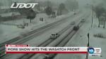
Road snow and slush will be present on roads throughout the I-15 corridor and mountains, according to the Utah Department of Transportation.
Salt Lake and Utah counties will experience road snow through the afternoon and evening hours Sunday, according to UDOT. Central Utah from Nephi to Cedar City will experience road snow Sunday night.
Poor road conditions will persist through much of the day Monday in the southern half of the state, according to UDOT.
Road Weather Alert: Cold Front Sunday Afternoon/Night Brings Statewide Road Snow and Slush. More Info and Forecast: https://t.co/rsT9lYglYq@UtahTrucking#utsnow#utwxpic.twitter.com/Pq0tXcq6J3
— UDOT Traffic (@UDOTTRAFFIC) December 29, 2018
Roads along the Wasatch Front were expected to be clear by the Monday morning commute, but UDOT officials advised drivers to beware of possible black ice due to low temperatures.
Did you take photos of the snow in your area today? Submit photos to KSL.com through iWitness below.
Check the KSL Weather forecast for the latest information.
Contributing: Tania Dean, KSL TV

Most recent Utah stories
Related topics
 Jacob Klopfenstein