Estimated read time: 2-3 minutes
This archived news story is available only for your personal, non-commercial use. Information in the story may be outdated or superseded by additional information. Reading or replaying the story in its archived form does not constitute a republication of the story.
RIVERDALE — After recent rainfall, the loss of homes sitting atop a moving landslide has become a question of "when" rather than "if."
"It's appearing to be inevitable at this point," Ben Erickson, hazards geologist for the Utah Geological Survey, said Wednesday.
"We've been anticipating it for a long time. So we know it's been coming, we're just now getting into the zone of when it's going to happen," he added.
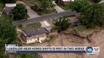
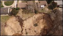
The geologist monitoring the Spring Creek Road Landslide said a sharp drop-off has moved closer to the homes within two weeks.
Those who lived in three homes, located along the west side of 600 West, were required to vacate in November. The occupants of a home located to the south voluntarily left in early March.
According to measurements by Erickson for the Utah Geological Survey, the slide drop off had come within 6 1/2 feet of one evacuated home as of Tuesday, and within about 30 feet and 41 feet of the other two. The edge was 44 1/2 feet away from the house where residents had left on their own.
For Dave Morgan, who since 1996 has lived in a home close to the ones that were evacuated, the situation feels like living "in limbo."
"People are selling their houses, and we don't know what's going on as far as the landslide because the city won't talk to us," he said Wednesday.
Morgan said that for other neighbors still living in the area, "What's sad is these people over here, it might affect them. They are in limbo. They have their boxes packed for the day that they say, 'You have got to leave.'"
City issues vacate orders for Riverdale homes near landslide
Riverdale city officials have sent a notice-to-vacate order to residents and mortgage lenders of three homes threatened by a landslide.The landslide's expansion is affected by "spring flow emanating from several points approximately halfway up the bluff," which erodes material, according to updates on the Utah Geological Survey website.
The landslide began in November on a steep "approximately 200-foot-high, thickly wooded west-facing bluff of Lake Bonneville deltaic deposits, above the Weber River floodplain," according to the Utah Geological Survey.
Fast-moving debris and earthflow "dislocated" soil and sand on the upper part of the bluff, the survey says. And since November, "several major and minor events" have caused the landslide to expand.
Contributing: Ashley Moser