Estimated read time: 3-4 minutes
This archived news story is available only for your personal, non-commercial use. Information in the story may be outdated or superseded by additional information. Reading or replaying the story in its archived form does not constitute a republication of the story.
SALT LAKE CITY — Weather experts are predicting several waves of rain and snow this week leading into Christmas, particularly in the mountains, where the avalanche alert is high.
Starting Sunday night, several waves of rain and light snow are expected to hit Utah's valleys, according to KSL meteorologist Dan Guthrie, while the mountains are likely to see significant snowfall.
The storm is expected to hit hardest Tuesday, when residents in the mountains can expect several feet of wet, heavy snow. Those in the valleys will likely get slushy snow and rain with some flooding, Guthrie said.
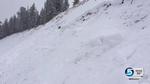
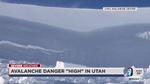
The conditions make for "all the makings of an avalanche accident," said Drew Hardesty, an avalanche forecaster with the Utah Avalanche Center.
"We're worried that we're going to have just enough water and snow to tip the balance," Hardesty said. "Right now we're on eggshells with avalanches here and there."
Heavy snow and strong winds, combined with weak snowpack that Hardesty called "rotten to the core," will likely trigger several large avalanches starting later Monday into the rest of the week, he said.
Hardesty said he expects avalanche danger to rise sharply to "high" or even "extreme" as the week continues. Affected areas include all mountains of northern Utah, the western Uintas and the Manti-Skyline plateau.
The center is asking people to avoid the backcountry altogether this week.
This week's storm has Avalanche Accident written all over it: Heavy snow, strong wind, rotten snowpack + Xmas break + powder fever. Be safe-
— UtahAvalancheCenter (@UACwasatch) December 20, 2015Even at the mountain resorts, Hardesty said, people need to stay inside the marked boundaries. What skiers and snowboards call "side country" can be just as dangerous as the backcountry, he said.
Last March, a 21-year-old snowboarder died in an avalanche in an out-of-bounds area at Snowbasin Resort. His body was found under 3 feet of snow.
Utah Department of Transportation workers will be plowing roads and laying down salt all week, according to UDOT spokesman John Gleason. Workers will focus on mountain areas like Big and Little Cottonwood Canyons, Parleys Canyon and Provo Canyon, which are expected to see significant snow.
The hazardous weather will begin Sunday night and continue into the day Monday, bringing mixed rain and snow to most of Utah and southwest Wyoming, according to the National Weather Service's Salt Lake City office.
Another wave will start Monday afternoon and continue into the day Tuesday, bringing rain and light snow to the valley and snow to the mountains.
Those traveling on Christmas Eve or Christmas Day should plan some extra time in their schedules, Gleason said. Over Thursday and Friday, experts say Utah could be hit with an inch or two of light snow. Those in southern Utah may get some snow as well.
That means road conditions may be bad during one of the busiest travel weeks of the year.
"There's more people out on the roads, people trying to wrap up their errands before the holiday," Gleason said. "We ask everybody to use extra patience this time of year. It's a great time of year to be a courteous driver."
Contributing: Nicole Vowell
Email: dchen@deseretnews.com Twitter: DaphneChen_