Estimated read time: 3-4 minutes
This archived news story is available only for your personal, non-commercial use. Information in the story may be outdated or superseded by additional information. Reading or replaying the story in its archived form does not constitute a republication of the story.
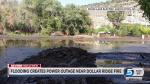
SALT LAKE CITY — A flash flood warning was issued in Kane County Thursday evening as officials urged the public to seek higher ground near the Paria River.
A "trained weather spotter" reported flash flooding along the river where it intersects with U.S. Highway 89, according to weather officials.
"Anyone in the lower Paria River basin or the Paria Narrows needs to move to higher ground immediately," the National Weather Service said in a tweet Thursday evening.
The warning is expected to last until 11:15 p.m.
#utwx@NWSSaltLakeCity monster flood just hit Paria at 89 pic.twitter.com/6CcHwW1NHl
— David Rankin (@Rankinstudio) August 24, 2018
#NWS_RT
Flash Flood Warning including Kane County, UT until 11:15 PM MDT pic.twitter.com/atFeN2u6Rt
— NWS Salt Lake City (@NWSSaltLakeCity) August 24, 2018
#NWS_tweet
Although the weather forecast has cleared in several parts of Utah following a storm and flash flooding Wednesday, some roads remain closed.
Duchesne County
About midnight, the Duchesne County Sheriff's Office tweeted several road closures due to heavy rainfall.
- Lower Red Creek Road south of U.S. 40. Lower Red Creek was out of its banks as of midnight Thursday, according to Duchesne County Road Department Director Ben Henderson.
- Sam’s Wash Road south of U.S. 40.
- Strawberry River Road south of U.S. 40 near Freedom Bridge over Starvation Reservoir.
Those roads will remain closed until crews clear them and inspect them for damage, the Twitter post said. Motorists are asked to avoid the area.
In the Camelot area, electric crews were sent to evaluate outage issues due to flooding, according to a Facebook post from the Moon Lake Electric Association, Inc. Crews believe it may be one week before they are able to start repairing damaged lines due to the severe flooding.

Utah and Summit counties
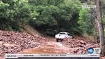
Flooding closed 8.6 miles of road near Diamond Fork Hot Springs in southeast Utah County Wednesday, officials said.
The road was closed starting at the Red Ledges picnic area, about 7 miles east of U.S. 6 on Diamond Fork Road, according to Utah County Sheriff's Office Sgt. Spencer Cannon.
Drone video from @SGTCannonPIO showing mud covering the road in Diamond Fork in Utah County. pic.twitter.com/jvkNetUiAP
— Devon Dewey (@DevonDewey) August 23, 2018
The closure continued to Springville Crossing, the junction of Diamond Fork Road and Hobble Creek Canyon, Cannon said.
Diamond Fork Road is expected to reopen Thursday.
Springville Crossing is the junction that goes north and west to Hobble Creek Canyon or east and south to Sheep Creek through Ray’s Valley and back to US Hwy 6. Bottom of blue line is Red Ledges picnic area. Top is Springville Crossing. Blue line area closed for at least 24 hrs. pic.twitter.com/IysL4e6bJ9
— Spencer Cannon (@SGTCannonPIO) August 23, 2018
In Summit County, heavy rain produced mud and debris that swept a car off Chalk Creek Road Wednesday. The people inside the vehicle got out safely, according to a tweet from North Summit Fire District.
Chalk Creek Road has reopened.
Southern Utah
Zion National Park closed four trails due to damage from storms:
- Angels Landing
- Upper Emerald Pools
- Kayenta Trail
- West Rim Trail from Grotto to Cabin Spring
Park officials did not give a timeline for when they would reopen.
The National Weather Service also reported flash flooding and nickel-sized hail in Kodachrome State Park.
Hail in Davis County
Ping-Pong ball-sized hail pounded areas of Fruit Heights, Kaysville, West Kaysville and beyond Wednesday afternoon, leaving a trail of damage to property including plants, garbage cans, and vehicles.
Rhee Braby said he was driving on I-15 in Kaysville when the hail started to fall.
“Yeah, it was loud!” Braby said. “It just kept coming and coming!”
There was no shelter for his car.
“Traffic was really, really slow and by the time I got to the underpass, it was full of people, so you couldn’t stop — you just had to keep going and survey the damage later,” Braby said.
His shiny black sedan sustained numerous small dents from fender to fender.

Hail caught in videos and in pictures from a storm that passed through Kaysville and Fruit Heights appeared to be larger than a quarter.
It piled up outside Alyssa Markham’s condo.
“They were huge!” she said.
Forecast
Storms that brought flash flooding and hail Wednesday ended overnight, and clearer skies are expected Thursday.
Clouds are still clearing out of the state early this morning after yesterday's severe weather.
— NWS Salt Lake City (@NWSSaltLakeCity) August 23, 2018
Look for warming temperatures and a drier trend. Still may see/smell some smoke in the air, from western wildfires. #utwxpic.twitter.com/3YvCndUrBS
Get the complete forecast on the KSL weather page.
Contributing: Andrew Adams, KSL TV and Yvette Cruz, KSL.com