'%3e%3cpath%20d='M34.1406%205.85938C30.3906%202.10547%2025.3047%200%2020%200C14.6953%200%209.60938%202.10547%205.85938%205.85938C2.10938%209.61328%200%2014.6953%200%2020C0%2025.3047%202.10547%2030.3906%205.85938%2034.1406C9.61328%2037.8906%2014.6953%2040%2020%2040C25.3047%2040%2030.3906%2037.8945%2034.1406%2034.1406C37.8906%2030.3906%2040%2025.3047%2040%2020C40%2014.6953%2037.8945%209.60938%2034.1406%205.85938ZM37.0117%2023.543H31.1602V13.5391H27.6328V19.9414C28.1211%2020.6914%2028.3711%2021.582%2028.3711%2022.5625V22.625C28.3711%2023.668%2028.1172%2024.6055%2027.6328%2025.4297V26.6094H36.082C33.4883%2032.9375%2027.2891%2037.3789%2020.0039%2037.3789C10.3711%2037.3789%202.62109%2029.6289%202.62109%2020C2.62109%2010.3711%2010.3711%202.62109%2020%202.62109C29.6289%202.62109%2037.3789%2010.3711%2037.3789%2020C37.3789%2021.1484%2037.2617%2022.2656%2037.0508%2023.3477C37.0391%2023.4141%2037.0234%2023.4766%2037.0117%2023.543Z'%20fill='white'/%3e%3cpath%20d='M22.3086%2018.5352C20.4336%2018.125%2019.9531%2017.8398%2019.9766%2017.1836V17.1406C19.9766%2016.6992%2020.3477%2016.2148%2021.4023%2016.2148C22.582%2016.2148%2023.8867%2016.6797%2025.0781%2017.4766L26.8516%2015.0195C25.4453%2013.8906%2023.707%2013.3398%2021.5547%2013.3398C18.5195%2013.3398%2016.4375%2015%2016.4063%2017.4766V17.5352C16.3633%2020.2617%2018.5859%2020.9805%2021.293%2021.6016C23.0391%2021.9766%2023.5703%2022.3164%2023.5703%2022.9609L23.5469%2022.9766C23.5469%2023.3906%2023.2578%2023.7031%2022.7852%2023.8359C22.5742%2023.9062%2022.1289%2023.9727%2021.5156%2023.9727C20.7617%2023.9727%2019.7539%2023.8633%2018.6328%2023.4844C18.0898%2023.2891%2017.4727%2023.0039%2016.8047%2022.6133L20.1406%2026.625C20.2813%2026.6602%2021.0977%2026.8516%2021.7734%2026.8516C25.0039%2026.8516%2027.0859%2025.2461%2027.1094%2022.6328V22.5703C27.1602%2020.1133%2025.2148%2019.1719%2022.3086%2018.5352Z'%20fill='white'/%3e%3cpath%20d='M5.24219%2013.5664V26.6133H8.75391V23.7578L10.2969%2021.9531L14.2031%2026.6133H18.3867L12.3555%2019.5195L17.4023%2013.5664H13.4531L8.75391%2019.0586V13.5664H5.24219Z'%20fill='white'/%3e%3c/g%3e%3cdefs%3e%3cclipPath%20id='clip0_97_2430'%3e%3crect%20width='40'%20height='40'%20fill='white'/%3e%3c/clipPath%3e%3c/defs%3e%3c/svg%3e)

Estimated read time: 4-5 minutes
This archived news story is available only for your personal, non-commercial use. Information in the story may be outdated or superseded by additional information. Reading or replaying the story in its archived form does not constitute a republication of the story.
- Salt Lake City launched the West-East Connections Study to address transportation barriers.
- The study will explore options to improve connections between the city's east and west sides.
- City officials secured $3.7 million for the study, aiming for solution options within two years.
SALT LAKE CITY — Turner Bitton knows all too well about the struggles that trains pose on his daily commute.
As a Glendale resident, he's often blocked by trains while trying to make it over to the city's east side or make it back home. Some of these trains can be stopped for hours, forcing drivers to detour several blocks to find one of the few access points linking both sides of the tracks.
Don't have a vehicle? Good luck.
"It can be a very long trip," said Bitton, chairman of the Glendale Community Council. "Folks who are on a short schedule. If a train stops, it can be a real problem."
Between I-15 and railroad lines, residents of Salt Lake City's west side have long fumed over the barriers that separate themselves from the rest of the city. The city is now looking at a way to reduce as many of those barriers as possible.
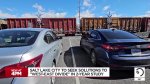
Salt Lake City announced Wednesday it has formally launched its much-anticipated West-East Connections Study to review options that can improve transportation connections between the two sides. The city plans to review options that can improve driving, walking, bicycling or riding transit across the city.
"Future transportation investments must reflect the voices of west-side residents — not just because it's the right thing to do, but because the best solutions come from the residents who live with these challenges every day," said Salt Lake City Mayor Erin Mendenhall in a statement. "The west side deserves more ways to connect, and this study is the next step in making them happen."
A long-standing divide
Salt Lake City's transportation divide dates back to the 1870s. Shortly after the transcontinental railroad was completed in Utah, railroad companies began building a corridor that helped link the city with the rest of the country.
That decision proved to be detrimental. City officials pointed out, in a description of the study, that the west side of the tracks became "less desirable and often used as a dumping ground for waste." The side had always been "racially, ethnically, and socioeconomically diverse," but the rails were used to help redline residents to that side in the 1940s.
The divide worsened in the late 1950s, as I-15 was constructed a few blocks west of the railroad. Today, only a handful of roads have bridges or tunnels that allow for traffic flow between the city's two sides, adding to road congestion and difficulty for neighborhood residents without vehicles.
"The east-west divide is more than just a mobility challenge. It's really feeling like the west side is underinvested in," said Joe Taylor, a Salt Lake City transportation planner. "That's what we're trying to get at with the folks who live it every day."
The city and other agencies have taken some steps to address the problem in recent years.
Salt Lake City and other agencies have already looked at a few ways to improve these barriers. In 2023, the Utah Transit Authority opened a pedestrian bridge along 300 North over the rails in a section often blocked by trains. Construction is expected to pick up this year on a 400 South trail over the freeway, following the Folsom Trail opening in 2022.
Bitton says he's also appreciative of the 9-Line Trail's expansion in the city.
Studying solutions
The new study aims to find larger solutions. City officials gathered $3.7 million to study the issue in recent years, a large chunk of which came from the U.S. Department of Transportation's Reconnecting Communities Pilot Program.
Taylor said the city is planning to review every possibility as it looks to close transportation gaps over the next two years.
"That can range from anything from major infrastructure to small treatments," he said. "We're wide open on what the solutions will be."
That could lead to more paths and bridges, or it could point to wider measures like the Rio Grande Plan, a resident-led initiative to bury the railroad lines across a large section of the corridor near downtown. The latter would allow freight and commuter trains to move through a tunnel while opening up dozens of acres for new development.
It's since gathered support from city and county officials but also requires massive funding with its estimated cost now ranging from $3 billion to $6 billion. Salt Lake City Councilman Dan Dugan told KSL.com last year that the Rio Grande Plan could be viewed in the study once it's started because it could solve the biggest barrier and open up new economic opportunities to recoup the cost.
"I think it's got a lot of potential," he said at the time. "This is the core section of town that we really need to connect well from east to west."
Contributing: Andrew Adams