Estimated read time: 4-5 minutes
This archived news story is available only for your personal, non-commercial use. Information in the story may be outdated or superseded by additional information. Reading or replaying the story in its archived form does not constitute a republication of the story.
LOS ANGELES — Nearly the entire population of California is under flood alerts as rain drenches the already-soaked state. Officials are urging people to stay off roads as they face the risk of flooding and landslides.
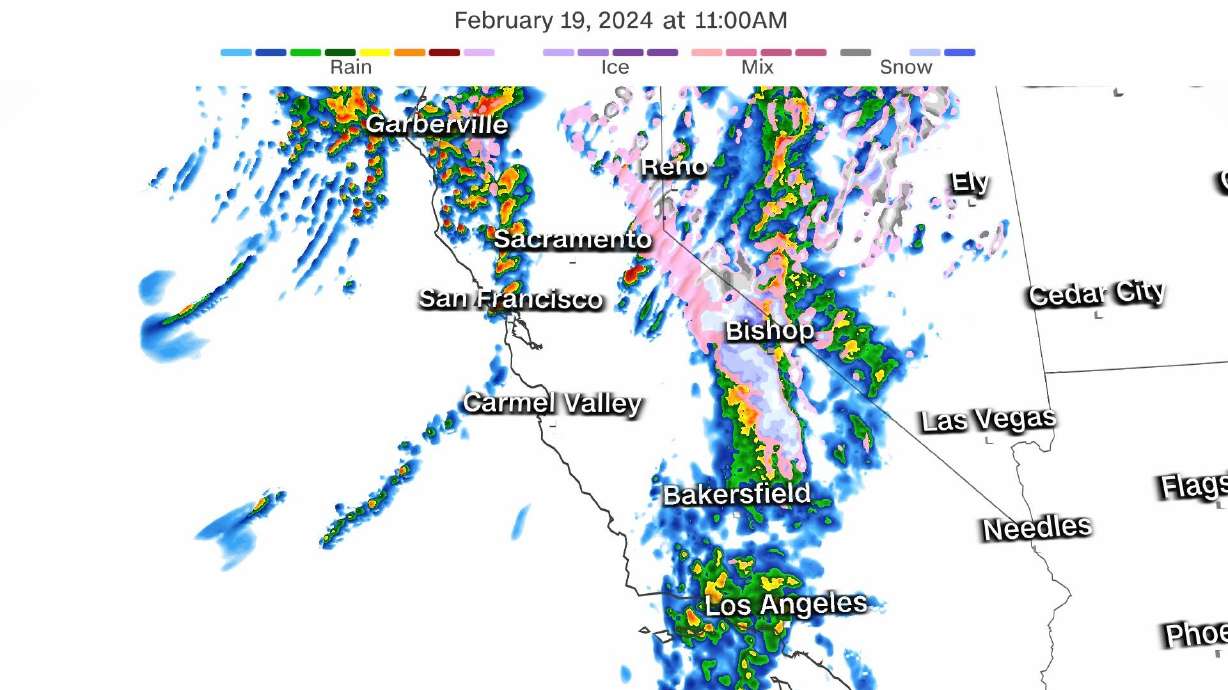
Torrential rainfall triggers flash flood warnings: Flash flood warnings were issued Monday morning for Santa Barbara and Ventura counties, where 2 to 5 inches of rain had already fallen, according to the National Weather Service. Area foothills are receiving some of the heaviest rain, increasing the chances for landslides.
More than 37 million people under flood alerts: Rounds of rain are soaking large portions of California Monday, but the heaviest is targeting Southern California. Repeated deluges may produce flooding across Santa Barbara and Ventura counties through Monday morning, before the axis of heavy rain shifts into the greater Los Angeles metro during Monday afternoon.
Airport and roads closed by flooding: The Santa Barbara Airport was closed due to flooding on Monday morning, the airport announced on X, formerly known as Twitter. A flooded portion of Highway 246 was shut down in both directions Monday morning in Santa Barbara County with no estimate for reopening, according to Caltrans. A portion of Highway 1 in nearby San Luis Obispo County was also shut down Monday.
Rare severe weather risk: A Level 2 of 5 risk for severe thunderstorms is in place for California's Sacramento Valley Monday – the first such forecast since February 2015. Severe thunderstorms packing damaging wind gusts, hail and even a couple of brief tornadoes may develop Monday afternoon and evening.
Evacuation warnings issued: Officials in Santa Barbara County issued evacuation warnings for several flood-prone areas Saturday in advance of the storm.
Heavy snow across Sierra Nevada: Feet of heavy, wet snow will bury the highest elevations of the Sierra Nevada through Wednesday morning. Up to a foot of snow is possible down to a few pass levels early this week. "Travel could be very difficult to impossible," the weather service warned.
Days of rain to keep flood threat elevated
Heavy rain will continue beyond Monday as the atmospheric-river-fueled storm stalls just off the West Coast. The Weather Prediction Center has issued excessive rain outlooks through Tuesday for much of California but the risk peaks at a Level 3 of 4 Monday.
The storm's atmospheric river connection will weaken a bit Tuesday and slightly ease overall rainfall intensity. Soaking rain will persist across a large portion of the state Tuesday, but any torrential deluges will be more isolated in nature.
Major cities facing the most flood risk over the next couple of days include Los Angeles with a Level 3 of 4 risk on Monday and Level 2 of 4 risk Tuesday, and Santa Barbara with a Level 2 of 4 risk on Monday and Tuesday.
The Los Angeles office of the National Weather Service warned that "significant flooding" is possible and 2 to 5 inches of rain are expected – with up to 10 inches in isolated areas of the Santa Lucias and Santa Ynez ranges.
Downtown Los Angeles could pick up between 2 and 3 inches of rainfall from Monday afternoon through Tuesday. Add this to the historic rainfall the city recorded earlier in the month, and this February could become Los Angeles' wettest on record.
Both this week's storm and the prolific early February storm were fueled by atmospheric rivers. However, the ongoing storm is tapping into much less moisture than the early-month storm and therefore is unlikely to become as extreme.
Warnings of possible large mud or rock slides on canyon roads and debris flows in areas recently burned by wildfires were also issued by the forecast office in Los Angeles.
An early round of rain arrived Friday night and Saturday with a separate storm. The early weekend rain soaked soils in Northern California's Del Norte County and caused a rock slide that shut down a portion of U.S. Highway 101.
The city of San Francisco, which also is under a Level 2 flooding rain risk through Tuesday, is providing some residents and businesses with 10 free sandbags. Officials are concerned about "excessive runoff from moderate to heavy rain," which may lead to flooding, according to a post from the city on X.
Portions of the Bay Area picked up 0.75 to 1.5 inches of rain from Friday night to early Monday morning, with higher amounts of 2 to 3.5 inches in the higher terrain near the coast.
Flooding began north of the Bay Area Sunday night. Sonoma County fire officials captured video of riverlike floodwaters running across a fully submerged road.
Current conditions. Video in from our Field Observers on Mark West Station Rd. Never drive around barricades and closed flooded roadways. Stay smart, don't get stuck, turn around, don't drown. #floodedroad#sonomacountypic.twitter.com/yvubyxjLHq
— Sonoma County Fire District (@SoCoFireDist) February 19, 2024
Rounds of rain will finally come to an end in California by late Wednesday as the main storm driving the soaking weather pushes eastward, crossing into the Rockies.
Contributing: Cindy Von Quednow, Ashley R. Williams, Elliana Hebert and Sara Tonks


