Estimated read time: 2-3 minutes
This archived news story is available only for your personal, non-commercial use. Information in the story may be outdated or superseded by additional information. Reading or replaying the story in its archived form does not constitute a republication of the story.
LOGAN — Cities typically use satellite imagery to study a floodplain, but those areas are often blocked by trees and vegetation. A drone from Utah State University is cutting through all of that.
As the Logan River moves to more average flows, from peak flows seen during May, researcher Ian Gowing said those major events brought a rare opportunity.
"We saw that the Logan River had reached 1,750 cubic feet per second," Gowing said — it's highest flow. The drone could launch as the river flow peaked. Two Utah cities, Logan and Nibley, were eager to have detailed high-resolution images of the floodplain.
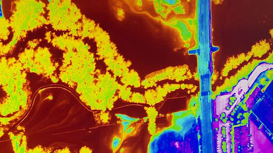
Gowing is a research engineer at USU's Water Research Laboratory. On May 24, he got the lab's director on board with getting very detailed maps of the waters flowing over the banks, using infrared technology. Approximately 19 miles of the Logan River were mapped during a flight while typically, researchers are only able get points along the river.
Darren Farar, Logan city engineer, said it was a major opportunity to now be able to pour over 19 miles of mapping and data not available before.

"That (infrared) spectrum allows us to be able to see into the foliage and kind of see exactly where that water is," Farar said. Ideally, it will give them the chance to better see which homes might be at risk in future major events.
"That has huge ramifications in terms of properties ... are they in the floodplain or are they not in the floodplain?"
Providing a clear picture of where the water is flowing, and cutting out anything that might get in the way, provides important data and there are plans for that important data.
"We have a number of Ph.D. students that will be doing some hydraulic modeling, using the imagery that we provided."
Those two cities and researchers will be looking over that data for months to come. Farar says that their mitigation system for the flood waters performed as they expected for this year, but they'll be able to better prepare for the future in adjusting those floodplain maps.