Estimated read time: 2-3 minutes
This archived news story is available only for your personal, non-commercial use. Information in the story may be outdated or superseded by additional information. Reading or replaying the story in its archived form does not constitute a republication of the story.
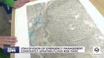
SALT LAKE CITY — It's safe to say Kathy Holder loves maps. What really has her attention these days, though, are flood plain risk maps.
Holder is Utah's hazard mitigation officer with Utah's Division of Emergency Management, and those maps are constantly on her mind.
"There is potentially going to be some flooding. It may be what they call nuisance flooding or some neighborhoods getting some flooding," Holder said. "That is likely to happen a lot more in the near future because of our snowpack."
It is no secret the snowpack this year has many people thinking of 1983.
Even the Division of Emergency Management's main office has a picture of Salt Lake City's State Street flooding from that historic year.
However, a lot has changed in 40 years.
The biggest difference is growth, which changes the flood plain risk maps.
"There's not places for the water to go and we're encroaching on those waterways and we're encroaching on to where the water would go," she said.
That is why the maps are constantly updated, because the flood plains are also changing all the time with growth.
Another difference from back then is newer neighborhoods are built with water detention and retention ponds, which are designed specifically to help collect flood water and keep it away from homes as best as possible.
"Every time if you see a new subdivision going in, you're seeing they're doing some basins, right? And some stormwater. So, in those ways, our stormwater people have been doing a great job. The problem is it just keeps upping as far as changes that are happening. It is a constant effort, and we are always working toward mitigating our risks," said Holder.
Cities and counties all across Utah have also been adding debris basins, culverts, and other stormwater management systems as part of their newer infrastructure.
Even still, no map can tell you exactly where flooding is going to happen, or how much.
However, those maps give you an idea.
And with all that snow still up in the mountains, it is better to have an educated guess than be caught by surprise.
"We know this is a record year," Holder said. "We got to be ready."
Background on Utah and flooding fast facts can be found here.
Additional flooding resources can be found below: