Estimated read time: 1-2 minutes
This archived news story is available only for your personal, non-commercial use. Information in the story may be outdated or superseded by additional information. Reading or replaying the story in its archived form does not constitute a republication of the story.
SALT LAKE CITY — The warm weather the Wasatch Front has been seeing over the past few days has turned into a cold and wet Sunday, but will return later in the week.
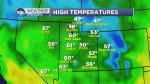
Some areas in Utah saw temperatures reach 60 degrees Saturday, but temperatures dropped drastically overnight as cold air moved in from the northwest. Salt Lake City was sitting at 31 degrees just after 10:30 a.m.
Meteorologist Dan Guthrie forecast "winter driving conditions" for the mountains with accumulations of less than half an inch for the Wasatch Front. But the snow was enough to reinstate the traction rule up Big and Little Cottonwood canyons Sunday morning.
Winter Weather Advisories are in effect for mountain areas like Alta and Brighton.
The Utah Department of Transportation website shows traffic generally running smoothly Sunday despite the snowfall.
Guthrie said southern Utah will see a mix of rain and snow, depending on elevation, Sunday evening after the cold front has pushed across the state.
The high for Sunday will reach 40 degrees and then move up one degree on Monday before it will be sunny and 60 again on Friday. Follow the latest at the KSL Weather Center.
Contributing: Graham Dudley, KSL.com