Estimated read time: 2-3 minutes
This archived news story is available only for your personal, non-commercial use. Information in the story may be outdated or superseded by additional information. Reading or replaying the story in its archived form does not constitute a republication of the story.
SALT LAKE CITY — It may be the start of meteorological fall, but the temperature outside Sunday afternoon was a good reminder that it’s very much still summer.
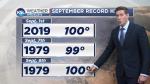
The National Weather Service reported it had recorded 100 degrees at its Salt Lake City International Airport location. It’s significant because it not only broke the previous high temperature for the day, 98 degrees, which was set on Sept. 1, 1995, but it’s also just the second time in history that it has reached triple-digits in September in Salt Lake City.
According to the weather service, the only other time it has ever reached 100 degrees was Sept. 8, 1979. There have been eight previous times it has reached at least 98 degrees in September. The most recent of those came on Sept. 3-4, 2017, when it reached 98 degrees.
🌡️☀️ We may have at least one more triple digit day left this summer at SLC. Current forecast for tomorrow (9/1) is 100°. This would tie our all-time hottest September temperature! Here are the warmest highs recorded in Sept since the late 1800s. #utwxpic.twitter.com/fZAm6osIUc
— NWS Salt Lake City (@NWSSaltLakeCity) August 31, 2019
“It’s been really hot and really dry, so when it gets really dry, you can warm up really fast, so we’ve got a warm air mass moving in. The old record was 98 and we hit the new record today,” KSL meteorologist Dan Guthrie explained.
"Most of the state dealing with very warm conditions," according to Guthrie. "And why wouldn't it? Plenty of sunshine out there, very dry air that helps you warm up very quickly during the day."
Guthrie also said that a weather station in Southern Utah reached temperatures up to 106 degrees.
However, for those of you looking forward to cooler weather, there is hope. Guthrie said Sunday is about as hot is it should get in the foreseeable future. A system is expected to bring more moisture into the state Monday.
“When moisture is in the air, it makes it harder to warm up,” he said. “We will start to cool down and we’ll actually have storms back in the state (Monday) night in southern Utah and then a potentially stormy week on and off this week.”
While meteorologists can’t really project more than a week out in advance, he said weather should be back into normal temperature ranges during the week, as well. [As the National Weather Service pointed out](https://twitter.com/NWSSaltLakeCity/status/1167878360212525058?s=20 target=>), average high temperatures tend to drop into the 70s by mid-September.
“We should cool down and we should stay right around seasonal range,” Guthrie added. “It looks like we’ll stay there until at least early next week. In fact, we can see highs in the lower 80s next week.”
Contributing: Dan Guthrie, KSL TV