Estimated read time: 2-3 minutes
This archived news story is available only for your personal, non-commercial use. Information in the story may be outdated or superseded by additional information. Reading or replaying the story in its archived form does not constitute a republication of the story.
SALT LAKE CITY — Utah’s first snowfall of 2019 is expected to hit the Wasatch Front overnight Saturday and into Sunday afternoon, weather officials report.
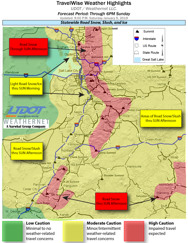
Snow accumulations of 2 to 4 inches are expected in some parts of Utah while the Wasatch and Western Uinta mountains could see anywhere between 3 to 14 inches, according to the National Weather Service.
❄️Snow developing overnight will impact travel across Utah into Sunday.
— NWS Salt Lake City (@NWSSaltLakeCity) January 5, 2019
⚠️Roads will be icy & slick with any accumulation.
⏲️Starting late tonight & through Sun evening, snow will accumulate in many locations.
Check with @UDOTTRAFFIC for road conditions.#utwx#utsnowpic.twitter.com/gslocUTOfK
#NWS_tweet
A winter weather advisory is in effect until 5 p.m. Sunday along the Wasatch Front in the Salt Lake, Tooele and Cache valleys. The weather advisory includes the following cities and surrounding areas:
- Logan
- Smithfield
- Brigham City
- Ogden
- Bountiful
- Salt Lake City
- Tooele
- Lehi
- Provo
- Nephi
- Wendover
- Snowville
Additionally, freezing rain is possible near Cache Valley, the Great Salt Lake and the Bonneville Salt Flats between midnight and early Sunday morning, the weather service said.
The Utah Department of Transportation posted a road weather alert on its website in preparation for a “wide variety of road weather concerns expected tonight and through Sunday.”
What to do if stranded in cold weather
Launching into early January in Utah, temperatures are plunging and the air has turned frigid. As great of a sign as this may be for ski season and water for the state come summer, the cold presents dangers that need to be prepared for.Several major roads were expected to be impacted by the weather including I-15, I-80, I-70, U.S. Highway 89, U.S. Highway 191, state Route 190 and state Route 210, to name a few.
Drivers are encouraged to slow down and use caution. Those heading up canyon and mountain roads should be prepared for chain restrictions, UDOT said.
#NWS_Map
For a complete list of routes and forecast conditions, click here.