Estimated read time: 3-4 minutes
This archived news story is available only for your personal, non-commercial use. Information in the story may be outdated or superseded by additional information. Reading or replaying the story in its archived form does not constitute a republication of the story.
SALT LAKE CITY — Flood worries are peaking across Utah as temperatures soar and a number of rivers threatened to rise above flood stage. Little and Big Cottonwood creeks and the Upper Weber River were expected to reach flood stage by the end of the day Thursday.
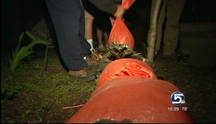
The fast-moving waters of Little Cottonwood Creek were threatening several cabins Thursday night. The owners of those cabins say they've been prepping for weeks by stacking sandbags and building higher rock walls.
Related:
Homeowner Tim Schwen says he and his neighbors had been following the path that the creek took during the floods of 1983, but Mother Nature pulled a fast one on him Thursday night and sent the water in a different direction. They've spent the last few hours sandbagging the new at-risk areas as water continues to rise.
"If (the water) comes through here, we'll open up the doors and put the flat-screen upstairs," Schwen said. "This house has been here for a long, long, long time."
Water watchers are most concerned about Little Cottonwood Creek because. They say because many people live near the creek, flooding could cause serious property damage.
Little Cottonwood Creek also runs through Murray Park. There, city crews and volunteers have built walls of sandbags and taken out bridges that would be just too dangerous to cross.
- Little Cottonwood Creek, 5 p.m. Thursday (exceeded flood stage at 7 p.m.)
- Big Cottonwood Creek, 9 p.m. Thursday
- Upper Weber River, 11 p.m. Thursday
- Upper Provo River, 2 a.m. Friday
- Upper Duchesne River, 7 p.m. Friday
- Upper Bear River, 11:59 p.m. Friday
Utah's water problem stems from mountain snowpack, which is up to 500 percent above normal levels in some areas. Officials have been warning for weeks of the potential for major flooding if the weather warmed rapidly, but they now say much of the snow has melted gradually over time and the major threats are gone.
"We feel we've reduced a good chunk of the snowpack that has melted off the past week, but we still have enough to create floods," said Brian McInerney, a National Weather Service hydrologist. "The hot temperatures have arrived and we still have a sizeable snowpack, but it's not the monstrous snowpack that we had two weeks ago."
McInerney said most residents should expect just minor to moderate flooding. He said some areas will very likely see water damage to homes and structures close to waterways, as well as flooded fields. Erosion has also already started causing some damage to structures downstream along the Duchesne River.
If the same amount of snow remained in the mountains as was there just two weeks ago, McInerney said, "We would have seen major, widespread flooding, but we're not."
For a National Weather Service map of current flood watches, warnings and advisories, CLICK HERE.
Also, residents of Vernal, Maeser, Jensen, Naples, and the unincorporated areas in Ashley Valley are being asked to stop using culinary water for outdoor use for the next 72 hours.
Due to high runoff, water storage and treatment systems that serve those areas are taking longer to meet water demands in the valley.
Written with contributions from Andrew Adams, Sarah Dallof and The Associated Press.


