Estimated read time: 2-3 minutes
This archived news story is available only for your personal, non-commercial use. Information in the story may be outdated or superseded by additional information. Reading or replaying the story in its archived form does not constitute a republication of the story.
SALT LAKE CITY -- Utah's wild and wacky weather this spring has dueling warnings in effect from the National Weather Service, with "explosive fire" potential for much of southern Utah and flood predictions for Uintah and Cache counties.
"Red Flag" warnings are in effect through 9 p.m. Sunday for southern San Juan County and the Henry Mountains and Natural Bridges National Monument below 6,500 feet. The Glen Canyon National Recreation Area and Lake Powell are under the same alert because of gusty winds, low humidity and dry vegetation.
Those conditions have merged to create "critical" fire weather.
In contrast, a flood advisory has been issued for the Green River near Jensen in Uintah County, where the forecast predicts the river will continue to rise over the weekend. It is anticipated it will exceed its banks late Sunday and reach flood stage by Wednesday afternoon.
Related:
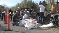
Community comes together in flood preparation
Legally blind and in his 80s, Keith Kemp was wondering how he was going to save his house. Thanks to volunteers Saturday morning, Kemp's house has a fighting chance.The National Weather Service is warning motorists to refrain from driving through flooded areas, noting that two feet of water is enough to float most vehicles. People are encouraged to stay away from flooded areas and riverbanks because they may be unstable.
Farther north, the Blacksmith Fork River in Cache County will reach flood stage between 5 a.m. and 7 a.m. Sunday morning. Housing developments in the Blacksmith Fork Canyon will be impacted, as well as homes at the river's confluence with the Logan River.
The flood warning is in effect through noon Tuesday.
Rick Williams, Cache County's Emergency Management director, said no flooding was reported in the area by Saturday night, but sheriff's deputies are patrolling the river 24 hours a day looking for problem areas.
"There's no property damage at all right now," he said late Saturday, but added, "We're at the mercy of Mother Nature. If we have another rain on snowmelt event like we had a couple weeks ago, we could have some problems."
Property owners are prepared, however, he said, with summer cabins that have been sandbagged for some time. Other flood control measures have been put in place along the banks, including water-deflecting riprap, or rocks.
The service is also warning that flooding is likely at the Weber River in Riverdale and Plain City and Emigration Creek could pose problems.
Meanwhile, anywhere from 14 inches to two feet of snow is expected to fall overnight Sunday into mid-Monday in the Wasatch and western Uinta mountains at elevations about 8,000 feet, adding to snowpack twice what the mountains normally get.
Record snowpack in many regions of the state — coupled with a narrow snowmelt season — prompted Gov. Gary Herbert on Friday to warn Utahns that acute flooding is imminent.
Residents should keep informed through the news and via Twitter alerts offered through cities where available and at utahemergencyinfo.com and bereadyutah.gov
Information can also be accessed by calling 2-1-1.
E-mail: aodonoghue@ksl.com