Estimated read time: 4-5 minutes
This archived news story is available only for your personal, non-commercial use. Information in the story may be outdated or superseded by additional information. Reading or replaying the story in its archived form does not constitute a republication of the story.
WASATCH FRONT -- This year's "phenomenal" snowpack is rivaling that of 1983, when rapid snowmelt turned the streets into rivers over Memorial Day weekend in downtown Salt Lake City.
With a wet storm pounding much of Utah over the last few days, more storms expected to occur next week and flooding already experienced in western Weber County, water managers are taking steps now to prevent a repeat.
"Cities and counties and towns and water districts should be looking at this very carefully and taking appropriate measures to prepare for high flows," said Randy Julander with the Utah Snow Survey. "We have a month and half to get ready to prepare."
That is not to say there will be a repeat because it is all in the hands of Mother Nature.
"When you look at 1983, our snowpacks were normal, it just kept snowing into June," said Brian McInerney, hydrologist with the National Weather Service in Salt Lake City.
"That spring weather is what we do not want to replicate."
Snowpack in the Wasatch Mountains east of Salt Lake County is at 145 percent of normal, McInerney said, and these latest storms are only going to add to that number and drive up the snowpack even more.
"We could have some problems, but if we shut off the rainfall and snow, we should be OK with regard to the flood threat."
McInerney is reluctant to make any comparisons to 1983, which saw widespread and legendary flooding problems throughout much of the state, from water-covered I-15 in Juab County to the Thistle mudslide in Spanish Fork Canyon.
Conservative estimates put the statewide spring flood damage totals at $200 million, and President Ronald Reagan granted "disaster" status to 12 impacted counties.
In that year, the water content in the snowpack continued to increase into early May, followed by a rapid escalation in temperatures.
"One thing we are looking at very critically here is what kind of April we have," Julander said. "April we want as smoking hot as we can possibly get it and then a dry, normal kind of May."
Julander said warm temperatures will melt the lower and mid-level snowpacks at manageable levels, and leave the "bomb proof" high mountain snowpack alone.
But even warmer weather in April that may be accompanied by normal precipitation does not equate to flood disasters, McInerney stressed.
"The most important component to this picture is the spring weather, and we do not know what that is just yet."
Water managers at districts throughout much of the state are already reducing the water levels at reservoirs to make room for runoff.
"The state of Utah is pretty much a favorable dumping grounds for snow this year," Chris Hogge said Friday in a briefing to members of the Weber Basin Water Conservancy District Board of Trustees.
Hogge, the district's manager over water supply and irrigation, said there's been a concerted effort to draw down the levels of all eight reservoirs within the basin.
"We're making space in the reservoirs for a high expected runoff flows."
Tage Flint, the district's general manager, said with the snowpack similar to 1983's, "we have to see how it melts and how it comes out. We get a lot of Monday morning quarterbacking in years like this."
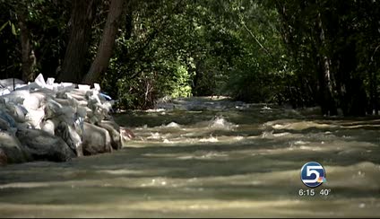
Flint said 2 inches of rainfall in Morgan County in mid-March caused the banks of the Weber River to overflow in farm country in west Weber, but there was no damage.
"It was surprising to see it that high in the middle of March."
Flint later said the district and others are better prepared for springtime anomalies than they were 28 years ago.
"It's impossible to predict what kind of spring we are going to have, but we try to prepare for some of those worst cases as opposed to not. The worst cases are where the dams can't control all the floods."
McInerney said while reservoir managers are concerned with the volume of flow in a river — that is how much is coming down at any given time — city and county public works folks will be more closely keeping an eye on peak rates — how high that water actually gets.
To that end, McInerney is making the rounds in Summit County and elsewhere in the state to give advice to those worried about street flooding and storm sewer systems should urban waterways become overrun.
He'll address a conference next week at Utah State University in Logan on spring runoff predictions based on what's known so far.
With snowpack levels at record or above record levels in multiple areas throughout the state — enhanced with high moisture storms not seen in eight years — Utah's water year that is due to officially end April 1 is rounding out to be among the best.
As is typical in Utah, the atypical accumulation of water — be it in the form of a drought or deluge — has everyone on their toes.
"It is sweet," Julander quipped, referencing the snowpack. "What can you say except for hot diggity dog … but if April is cold and wet, it's Katy bar the door."
Written by Amy Joi O'Donoghue with contributions from Jed Boal