Estimated read time: 2-3 minutes
This archived news story is available only for your personal, non-commercial use. Information in the story may be outdated or superseded by additional information. Reading or replaying the story in its archived form does not constitute a republication of the story.
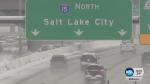
SALT LAKE CITY — A storm that slammed Utah with snow and cold temperatures slowed the commute for a second day Tuesday.
Lake effect snow brought whiteout conditions to some areas of northern Utah overnight and continued to fall into the early morning hours, leaving motorists to deal with messy roadways Tuesday morning. Dozens of crashes and slide-offs were seen, according to the KSL Newsradio Traffic Center.
A look at the lake effect snow now in Midvale. A crash is reported near 7200 South. pic.twitter.com/eEeeD828bX
— Heather Kelly (@KSLHeatherKelly) February 20, 2018
Speeds slowed considerably on freeways along the Wasatch Front as drivers navigated slick and snow packed conditions in spots. Common speeds on the 201 freeway in West Valley City were 30 miles per hour, according to the KSL Newsradio Traffic Center.
Cars are weaving around this crash scene — on icy roads. Not good. pic.twitter.com/SBMvRO242v
— Heather Kelly (@KSLHeatherKelly) February 20, 2018
At least 26 major crashes that impacted interstate and highway traffic were reported between midnight and the Tuesday morning commute, the Utah Department of Transportation said.
Decent driving conditions 2100 N in Lehi to South Interchange. From South Interchange north I-15 is snow packed and icy with some cars going 25 mph and others at 70 mph. Please slow down!
— SLCo Emergency Mngt. (@SLCoEmerMngt) February 20, 2018
Monday, the Utah Highway Patrol dealt with more than 500 crashes, including four UHP vehicles that were hit.
Some TRAX trains experienced delays up to 30 minutes due to power outages and door issues, Utah Transportation Authority tweeted.
And in Provo, crews restored power to 975 customers who had lost service Tuesday morning. Six customers will likely remain without power throughout the day, Provo Power officials said in a tweet.
Power lines, cross arms and transformers are down. Crews working to get some customers back on, however the power is expected to be out most of the day. pic.twitter.com/LxV6fOmakS
— Provo Power (@ProvoPower) February 20, 2018
School delays
All schools in Dugway are on a two-hour delay Tuesday morning with classes beginning at 10 a. m.
And Intermountain Christian School in Holladay will have an hour delay, according to Principal Laurie Bradt.
In a tweet, the Granite School District asked for patience as buses were running about 40 minutes late due to weather.
JUST IN: School is IN SESSION for the @canyonsdistrict. District says it will be lenient with those who arrive late due to the weather conditions. Be safe! #KSLAM#Utah#utahschools#UtWxpic.twitter.com/CXn2oGPYDg
— Shara Park (@KSLSharaPark) February 20, 2018
The storm brought record amounts of snow for a 24-hour period to parts of Utah Monday, according to KSL Meteorologist Grant Weyman.
More than a foot of snow fell in the Wasatch Mountains at ski resorts.
Ski Utah reported the following snow totals for the last 48 hours:
Alta: 21”
Beaver: 19”
Brian Head: 22”
Brighton: 21”
Cherry Peak: 20"
Deer Valley: 18”
Nordic Valley: 7"
Park City Mountain: 18”
Powder Mountain: 17”
Snowbasin: 14"
Snowbird: 23"
Solitude: 18"
Sundance: 12”
Scattered snow showers were expected to continue throughout the morning with clearing in the afternoon.
Get a complete forecast here. And check the KSL Traffic Page and get updates on KSL Newsradio.


