Estimated read time: 2-3 minutes
This archived news story is available only for your personal, non-commercial use. Information in the story may be outdated or superseded by additional information. Reading or replaying the story in its archived form does not constitute a republication of the story.
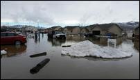
COTTONWOOD HEIGHTS — Floodwaters overwhelmed several northern Utah communities in recent weeks when heavy rains and warm temperatures melted low-elevation snowpack.
The warm weather this week, however, is the best-case scenario for those in Box Elder, Cache and Weber counties, according to Mark Millet, director of the Box Elder County Emergency Management. It should give an opportunity for them to dry out.
"A week or two of very warm, very dry allows time for the soils to drain and dry out a little bit,” said Randy Julander, Utah snow survey expert with the U.S. Natural Resources Conservation Service.
Most low-elevation snow is gone, and flooded communities won't likely face more trouble until the spring runoff begins more than a month from now. The warm weather will allow the soils to drain and dry out a little bit.
"Solar radiation is what melts snowpack, and that, for our snowpack right now, is absolutely a great thing,” Julander said.
"If we have clear sunny days, warm temperatures in April, what it does is it brings a lot of the low-elevation snowpacks off, and then we have a very sequential kind of melt," Julander added. That’s when the lower elevation snowpack melts off, then the mid-elevation snowpack, and the high-elevation snowpack does not start for another month.
If the low- and mid-level snowpack doesn’t melt until June, then it comes down with the higher elevation snowpack, “then what you get is concurrent snowmelt from all elevations. That really sends rivers over their banks quickly,” Julander said.
In years with exceptionally deep snowpack, like this year, the difference between exceptionally high spring flows that produce flooding in June and just high flows is the weather in March and April, he said.
Related:
“This is the time to get all of that snow out of the way down the stream channels before that high elevation stuff starts to come off,” Julander said. “That hasn’t even started yet.”
The water equivalent in the higher elevation snowpack is 2- to 4-feet deep.
“Hot temperatures ... people think it’s going to be 70 (degrees) so it’s all going to melt. Not even close,” Julander said. "The snowpacks have so much cold stored in the snowpacks themselves, it takes a long time to get the temperatures of the entire snowpack above freezing before it starts to melt.”
He said the amount of snow in the mountains is going to take quite a bit of time to actually melt.
“We’ll probably see high flows well into June and possibly into July,” he said.
The upper-elevation snowmelt creates the high stream flows and potential flooding in May and June. Julander said high flows will start in May running well into June and even July, possibly leading to some flooding, but releasing some of that volume of water now will certainly help.
Contributing: Viviane Vo-Duc


