Estimated read time: 3-4 minutes
This archived news story is available only for your personal, non-commercial use. Information in the story may be outdated or superseded by additional information. Reading or replaying the story in its archived form does not constitute a republication of the story.
SALT LAKE CITY — Wildfires rage on in southeastern Australia and pose additional threats to the country.
What we know
The first reported wildfires started in September, caused by hotter and drier weather. This has led to Australia's deadliest fire season.
Sunday's update by the Associated Press confirmed 3,000 homes destroyed and 33 people killed. Last week the AP reported over 26.2 million acres of land razed so far, though heavy rains have helped conditions this week.
A state of emergency was declared in Canberra, Australia, on Jan. 31. Wind-carried embers threatened Canberra's southern suburbs, but that fire has since been contained.
Firefighters may continue to battle flames for weeks, Australian Capital Territory Chief Minister Andrew Barr told the Associated Press.
Australians protested outside the Parliament House in Canberra on Feb. 4 as lawmakers memorialized the 33 wildfire victims. Protestors ordered lawmakers to update climate change policies — specifically about carbon emissions, according to the Associated Press.
Rebels from across the continent congregated in Canberra, encircling Parliament House with thousands of allies, demanding govt.#TellTheTruth about the #ClimateEmergency.
— Extinction Rebellion Australia (@XRebellionAus) February 4, 2020
Deepest thanks to the @PCA_Australia for a powerful week and the Aboriginal Tent Embassy for your hospitality pic.twitter.com/VueNpw44Wo
Twitter users are calling the wildfires a climate emergency. One user shared an image of the damage, comparing the fire's impact to a nuclear bomb. Another pleaded with everyone to cut down their carbon footprint and help the koalas.
Smoke Plumes
Climate Signals illustrates the link between greenhouse gas emissions, climate change and the 2019-2020 Australia wildfires.
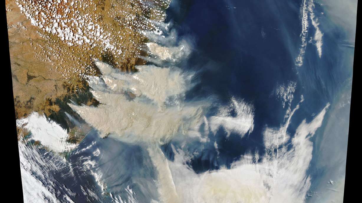
The large plumes of smoke created by the wildfires continue to emit gases into the atmosphere. According to NASA, these clouds of smoke are reaching record levels.
This NASA image shows smoke covering the area south of Canberra.
Drinking water
Longer fire seasons and a warmer climate put watersheds at risk. Researchers say watersheds hold a majority of the world's larger cities' water supply, according to the Associated Press's article Tuesday.
Australia's drinking water, though not majorly affected now, could be in future danger. Heavy rainfall could cause erosion and a sweep of ash and debris into waterways. This would have serious impacts on the country's ecosystems.
Wildlife
According to the World Wide Fund for Natural Australia, around 1.25 billion animals have lost their lives from the fire.
This includes thousands of koalas, kangaroos, wallabies, kookaburras, cockatoos and honeyeaters. Thousands more remain injured and homeless, according to WWF Australia, and they say it's just the beginning.
"Across Australia, fires have destroyed communities and forced thousands from their home. Habitats have been destroyed. Unique ecosystems decimated. And animals burnt to death."
— WWF-UK (@wwf_uk) February 3, 2020
This is the terrifying reality of the #AustraliaFires. #AustraliaOnFirepic.twitter.com/avrRkudfLt
Affected areas
This map shows current weather hazards in Australia.
Below are high-resolution images of some affected areas in New South Wales, Australia. The images are provided by Nearmap, a Sydney-based company that also has a location in South Jordan.
Beach St., Wallabi Point, NSW, Australia
Crowdy Bay, NSW, Australia
Crowdy St., Harrington, NSW, Australia
Near a shopping center in Forster, NSW, Australia
Harrington, NSW, Australia
Wallabi Point, NSW, Australia


