
- The National Weather Service issued a winter weather advisory for parts of Utah's mountains.
- Northern Utah could see its first valley snow this week, possibly Tuesday night.
- A second storm on Thursday may bring heavier mountain snow and a greater chance of valley snow.
SALT LAKE CITY — The National Weather Service has once again issued a winter weather advisory for Utah's mountains, but Utah's latest storm could bring some of the first valley snow of the season to northern Utah.
If it doesn't happen on Tuesday, there's a greater possibility later in the week.
A wet start to the week
Utah broke a small lull in storm activity over the weekend with a solid collection of valley rain and mountain snow. Some parts of the southern mountains, including Brian Head Resort, tallied close to a foot of new snow, with 2 to 6 inches falling across the northern mountains.
It was enough for Brian Head to announce it will open Tuesday, officially launching Utah's 2026-2027 ski season. It had hoped to open earlier this month, but that got delayed by the storm inactivity.
Salt Lake City recorded 0.41 inches of rain as its above-normal November continues.
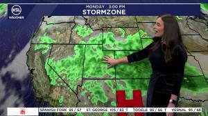
The next storm is forecast to follow a similar trajectory. A low-pressure system off the Pacific Northwest coast Monday morning will push a mix of valley rain and mountain snow toward Utah, KSL meteorologist Matt Johnson said.
Some showers are possible in southern Utah Monday night, especially in the mountains, but most of the moisture is expected to arrive along Utah's western half by late Tuesday morning.
"These showers ... will turn into full-bore rain across the Wasatch Front (by midday)," he said.
Some of these showers will linger into the afternoon and potentially into the evening, particularly in northern Utah. It could produce a rain-snow mix or even snow across the Wasatch Front and its benches Tuesday night.
Advisories issued
The weather service's advisory originally applied to the southern mountains, but it has since been expanded toward the Wasatch Mountains.
The advisory states:
- About 4 to 8 inches of snow is possible between Tuesday morning and Wednesday morning in areas above 8,000 feet, with 1 to 4 inches possible in the Wasatch Back, including Park City. Amounts closer to a foot are possible in the Upper Cottonwood Canyons.
- Approximately 1 to 5 inches of snow is possible in areas below 8,000 feet in the southern mountains between Monday night and Tuesday night, while 5 to 10 inches is possible above it. Brian Head and the Tushars could end with "locally higher amounts" closer to a foot.
The storm also has the potential to deliver a third to over a half-inch of precipitation across the Wasatch Front and northern Utah, and upwards of a half-inch in southern Utah. Central valleys may end up with 0.1 to 0.4 inches.
A weather service model updated Monday afternoon suggests some communities across Utah's northern half have a better chance of receiving trace or potentially measurable snow.
Higher-elevation communities like the Bountiful Bench and Cottonwood Heights have the best chance of receiving measurable snow, with expected amounts ranging from 1 to 3 inches. Even Salt Lake City's official airport site has a 50/50 shot of receiving measurable snow.
It wouldn't be out of the ordinary because Salt Lake City's average first day of snow is Nov. 9. Its first snowfall last year was on Dec. 27, its second-latest on record.
Another storm waits in the wings
A second storm that's forecast to arrive on Thursday will provide a greater chance of valley snowfall to close out the workweek, Johnson said.
High temperatures may only top out in the low 40s across the Wasatch Front on Friday and Saturday, with overnight lows dipping into the 20s.
It's also expected to deliver heavier mountain snow, which could allow more Utah resorts to open this weekend as planned.
Full seven-day forecasts for areas across Utah are available at the KSL Weather Center or on the KSL Weather app.