
Estimated read time: 2-3 minutes
This archived news story is available only for your personal, non-commercial use. Information in the story may be outdated or superseded by additional information. Reading or replaying the story in its archived form does not constitute a republication of the story.
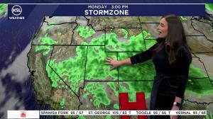
SALT LAKE CITY — Forecasters are predicting a wet Monday morning for commuters in Utah. According to the Utah Department of Transportation, a cold front will bring snow between 5 a.m. and 5 p.m., especially in the mountain areas from Summit County to Cache County. "All upper canyons and summits across northern Utah will see at least a couple inches of road snow, with the highest snow totals expected in the Cottonwoods and along US-89 near Logan Summit," UDOT said in a weather alert.
Road Weather Alert: A cold front will bring road snow to northern Utah between 5 AM and 5 PM on Monday, with light accumulations possible in the northern valleys and benches during the AM commute. For more information visit: https://t.co/AyNspjkXhL@UtahTrucking#UTWX#UTSNOWpic.twitter.com/CDZLJc59b7 — UDOT Traffic (@UDOTTRAFFIC) November 17, 2024
UDOT also is warning of snow accumulating along the Interstate 15 corridor north of Farmington and the Interstate 215 benches in the Salt Lake Valley. For Monday morning, UDOT is predicting these roads will be affected by the morning snow:
- I-15, North of Farmington
- I-84, Entire Route
- I-80, Mouth of Parley's Canyon to WY Border
- I-215, Eastern bench
- SR-190, Big Cottonwood Canyon
- SR-210, Little Cottonwood Canyon
- US-40, I-80 Jct. over Mayflower Summit; Daniels Canyon/Summit
- US-6, Soldier Summit
- US-89, Logan Summit through Bountiful
- US-191, US-191 Summit
- SR-30, Curlew to I-84 Jct
- SR-39, Entire Route
- SR-150, Entire route (Bald Mtn Pass)
- SR-35, Francis through Wolf Creek Summit
- SR-31, Skyline
- SR-44, Summit
The National Weather Service of Salt Lake City predicts that the snow will continue through Tuesday afternoon in the higher elevations and might go into Wednesday. The NWS also forecasts that Tuesday and Wednesday morning will be the coldest mornings that Utah has experienced so far in the winter season.
We'll see dry conditions for Sunday, but a cold storm system will bring accumulating snow to much of northern Utah Monday into Tuesday, with the best coverage of snow expected Monday morning. We'll also see some of the coldest temperatures of the year so far. #utwx#wywxpic.twitter.com/8rfBGKdJTN — NWS Salt Lake City (@NWSSaltLakeCity) November 17, 2024