Estimated read time: 3-4 minutes
This archived news story is available only for your personal, non-commercial use. Information in the story may be outdated or superseded by additional information. Reading or replaying the story in its archived form does not constitute a republication of the story.
SALT LAKE CITY — Severe thunderstorm warnings have been issued for parts of the Wasatch Front and southern Utah as large portions of the state remain under a severe thunderstorm watch for Friday. Meteorologists say strong winds, heavy rainfall and large hail are possible with these storms. Wind gusts could reach up to 70 mph and hail up to 2 inches is possible. Parts of southeastern and eastern Utah are under flood watches through Friday evening.
1:15 p.m.
Severe thunderstorm warnings are in effect for northern Utah County and southern Salt Lake County through 1:15 p.m. while Big Water and parts of Lake Powell are under a warning through 1:45 p.m. Parts of the Salt Lake Valley could see 50 mph winds and half-inch-sized hail through 2 p.m.
A special weather statement has been issued for Salt Lake City UT, West Valley City UT and Millcreek UT until 2:00 PM MDT pic.twitter.com/3t5YJiAWlT — NWS Salt Lake City (@NWSSaltLakeCity) June 21, 2024
Severe Thunderstorm Warning including Big Water UT until 1:45 PM MDT pic.twitter.com/a6nTAG1Zb4 — NWS Salt Lake City (@NWSSaltLakeCity) June 21, 2024
Severe Thunderstorm Warning including Lehi UT, Riverton UT and Herriman UT until 1:15 PM MDT pic.twitter.com/28iyTytrLU — NWS Salt Lake City (@NWSSaltLakeCity) June 21, 2024
The National Weather Service issued flood watches covering several Utah communities, including Blanding, Escalante, Green River, Kanab, Moab and Torrey, which will be in effect from noon to 9 p.m. on Friday. "Anomalously high moisture content air will combine with a mid-level disturbance to aid in the development of strong thunderstorms capable of heavy rainfall," the flood watch states. "Heavy rainfall may result in flooding of slot canyons, recent burn scars, normally dry washes and other flood-prone locations." https://ksltv.com/655511/eastern-utah-bracing-for-extreme-weather/ Some showers and thunderstorms tied to Alberto's moisture have already impacted parts of southeast Utah on Friday after some storms on Thursday; however, most of the Alberto-related storm activity is expected in the afternoon and evening, impacting most of eastern, central and southern Utah. "(We're expecting) a cluster and complex of storms across the Utah mountains, mainly I-15 eastward, including southwest Wyoming, the Uinta Basin and even extreme southeast Utah," said KSL meteorologist Matt Johnson, adding there could be strong "standalone storms" in parts of the state that could produce heavy rainfall in a short time.
SLIGHT RISK: Deep moisture from Alberto and a passing low pressure system today will fire up some stronger storms in southeast Utah. Primary threats include: heavy rain, microburst winds up to 60 mph, 1"+ hail and even a sliver of a chance for some spin-ups. #utwxpic.twitter.com/1qrz2cLPP3 — Matthew Johnson (@KSL_Matt) June 21, 2024
Residents aren't the only ones who should pay attention to the flooding potential. Flash flooding is considered "likely" in popular recreation areas like Arches, Canyonlands and Capitol Reef national parks, as well as Lake Powell and Grand Staircase-Escalante National Monument. Flooding is also possible in areas like Zion National Park.
As a note, a Severe Thunderstorm Watch means that conditions are unusually favorable for the development of severe thunderstorms that could produce large hail and strong winds. If severe weather is imminent or occurring, a warning will be issued for the impacted area. #utwxhttps://t.co/zZj5HWUPKG — NWS Salt Lake City (@NWSSaltLakeCity) June 21, 2024
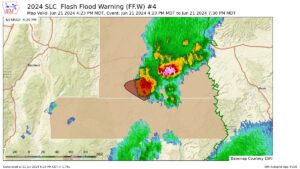
According to the National Weather Service, a flashflood warning was issued to Southern Utah's parts Friday. Officials said slot canyons including Chimney, Ramp, Ding and DAng, Music, Bell, Little Wildhorse, and Chute Canyons should be avoided.
Contributing: Carter Williams, KSL.com, and Shelby Lofton, KSL TV