'%3e%3cpath%20d='M34.1406%205.85938C30.3906%202.10547%2025.3047%200%2020%200C14.6953%200%209.60938%202.10547%205.85938%205.85938C2.10938%209.61328%200%2014.6953%200%2020C0%2025.3047%202.10547%2030.3906%205.85938%2034.1406C9.61328%2037.8906%2014.6953%2040%2020%2040C25.3047%2040%2030.3906%2037.8945%2034.1406%2034.1406C37.8906%2030.3906%2040%2025.3047%2040%2020C40%2014.6953%2037.8945%209.60938%2034.1406%205.85938ZM37.0117%2023.543H31.1602V13.5391H27.6328V19.9414C28.1211%2020.6914%2028.3711%2021.582%2028.3711%2022.5625V22.625C28.3711%2023.668%2028.1172%2024.6055%2027.6328%2025.4297V26.6094H36.082C33.4883%2032.9375%2027.2891%2037.3789%2020.0039%2037.3789C10.3711%2037.3789%202.62109%2029.6289%202.62109%2020C2.62109%2010.3711%2010.3711%202.62109%2020%202.62109C29.6289%202.62109%2037.3789%2010.3711%2037.3789%2020C37.3789%2021.1484%2037.2617%2022.2656%2037.0508%2023.3477C37.0391%2023.4141%2037.0234%2023.4766%2037.0117%2023.543Z'%20fill='white'/%3e%3cpath%20d='M22.3086%2018.5352C20.4336%2018.125%2019.9531%2017.8398%2019.9766%2017.1836V17.1406C19.9766%2016.6992%2020.3477%2016.2148%2021.4023%2016.2148C22.582%2016.2148%2023.8867%2016.6797%2025.0781%2017.4766L26.8516%2015.0195C25.4453%2013.8906%2023.707%2013.3398%2021.5547%2013.3398C18.5195%2013.3398%2016.4375%2015%2016.4063%2017.4766V17.5352C16.3633%2020.2617%2018.5859%2020.9805%2021.293%2021.6016C23.0391%2021.9766%2023.5703%2022.3164%2023.5703%2022.9609L23.5469%2022.9766C23.5469%2023.3906%2023.2578%2023.7031%2022.7852%2023.8359C22.5742%2023.9062%2022.1289%2023.9727%2021.5156%2023.9727C20.7617%2023.9727%2019.7539%2023.8633%2018.6328%2023.4844C18.0898%2023.2891%2017.4727%2023.0039%2016.8047%2022.6133L20.1406%2026.625C20.2813%2026.6602%2021.0977%2026.8516%2021.7734%2026.8516C25.0039%2026.8516%2027.0859%2025.2461%2027.1094%2022.6328V22.5703C27.1602%2020.1133%2025.2148%2019.1719%2022.3086%2018.5352Z'%20fill='white'/%3e%3cpath%20d='M5.24219%2013.5664V26.6133H8.75391V23.7578L10.2969%2021.9531L14.2031%2026.6133H18.3867L12.3555%2019.5195L17.4023%2013.5664H13.4531L8.75391%2019.0586V13.5664H5.24219Z'%20fill='white'/%3e%3c/g%3e%3cdefs%3e%3cclipPath%20id='clip0_97_2430'%3e%3crect%20width='40'%20height='40'%20fill='white'/%3e%3c/clipPath%3e%3c/defs%3e%3c/svg%3e)


Estimated read time: 6-7 minutes
This archived news story is available only for your personal, non-commercial use. Information in the story may be outdated or superseded by additional information. Reading or replaying the story in its archived form does not constitute a republication of the story.
SALT LAKE CITY — In a recent article, I showcased photos from some of my favorite Utah ghost towns. Many readers requested more information on how to find these towns, so I've compiled this list of five ghost towns that will allow you to see some of our state's most stunning relics from the past.
It is important to note that most of these destinations are either partially or entirely on private property. Visitors should always respect the law when exploring ghost towns.
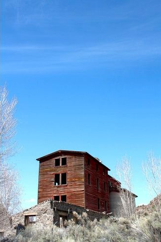
GRAFTON: This is one of the most accessible ghost towns in the state. It's so beautiful and well preserved that it's been used as a setting for multiple films, including "Butch Cassidy and the Sundance Kid."
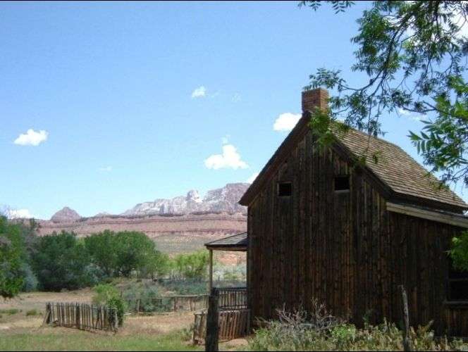
The history: This area was settled in 1859, but the town was nearly destroyed during the great flood of 1862. The resilient residents moved a mile upstream on the Virgin River and built a new town they named Grafton, after Grafton, Mass.
In 1866, Utah was in the midst of the Black Hawk War and Grafton was one of the many remote settlements that were abandoned for fear of Indian attacks. People began returning in 1868, but flooding from the notoriously volatile Virgin River again became a major threat to the town's safety. By the early 1900s, most of the residents had moved away and only a few families remained.
What remains: The Grafton Heritage Partnership has done a remarkable job of restoring and protecting the town's remaining structures. The old stone church is Grafton's crown jewel, and you'll also find multiple homes and barns to visit. Also make sure to visit the historic cemetery.
How to get there: Grafton is located just west of the town of Rockville on State Route 9. Take Bridge Road over the river and then follow it westward as it parallels the river to the town site.
WIDTSOE: Though much of the town has been destroyed, Widtsoe boasts one of the most picturesque relics in Utah—its solitary schoolhouse.
The history: Like many early Utah settlements, Widtsoe went through a long series of name changes. In 1902 it was named Adair, in honor of an early settler. This was changed to Houston shortly thereafter, and then changed to Winder in 1910. Seven years later, the post office decided that there were too many "Winders" in the region and changed the name to Widtsoe, in honor of John A. Widtsoe, who was a developer of the dry farming techniques used in the area.
The town thrived as new farming techniques allowed success in the rough conditions. Soon Widtsoe had hotels, stores, a post office, and the aforementioned schoolhouse. But extended drought conditions thwarted even the most resilient farmers and the population began to decline. By the mid-1930s, the town was abandoned.
What remains: In addition to the gorgeous schoolhouse, Widtsoe has a handful of other surviving homes and sheds.
How to get there: Widtsoe is on the east side of State Route 22, about 24 miles south of Antimony.
OSIRIS: Located next to a beautiful stream in Black Canyon, the Osiris creamery is a magnificent sight to behold.
The history: Settled in 1910, this town along the east fork of the Sevier River was originally called Henderson in honor of a Panguitch man who donated the land. But then the Holt family from nearby Widtsoe came in and constructed a massive creamery and summer home. For reasons unknown, they named the site Osiris, after the Egyptian god of the afterlife.
In an attempt to make the operation more lucrative, the creamery was later converted into a grain mill. However, harsh weather conditions and poor farming doomed the settlement and it was abandoned in the 1920s.
What remains: The enormous creamery is on private property, which has enabled it to remain in excellent condition over the years. Across the street from the creamery is the Holt family home site.
How to get there: The Osiris creamery and home site are easily visible from State Route 22, about 10 miles south of Antimony.
FRISCO: This iconic ghost town boasts some of the most stunning and well-preserved structures in Utah.
The history: When silver was discovered in Utah's San Francisco Mountains in 1875, the ensuing boom spawned the wild mining town of Frisco. With more than 20 saloons, brothels and gambling halls, Frisco's residents worked the mines by day and indulged in debauchery by night. Gunfights were common and a famed Nevada lawman was eventually brought in to stem the rising tide of murders.
At its peak, Frisco had nearly 6,000 residents and was the commercial hub for the district. It had hotels, churches, stores, a post office, a school and a hospital. And as a terminus of the Utah Southern Railroad, it enjoyed all the financial benefits of being connected to the rail line.
In 1885, a catastrophic cave-in of the area's most productive mine brought the prosperity to a halt. Some tenacious miners continued to work Frisco's mines for the next several years or so, but by 1920 the town was abandoned.
What remains: Frisco is a treasure trove of relics (although there aren't any real relics lying around). There are multiple buildings still standing, as well as extensive mining structures. The highlights of the area are the town cemetery and the beautiful beehive kilns that are on the National Register of Historic Places.
How to get there: Frisco is just off State Route 21, about 15 miles northwest of Milford.
THISTLE: This one-of-a-kind ghost town allows visitors to see firsthand the terrible effects of a 1983 landslide that dammed the Spanish Fork River and left the town underwater.
The history: Thistle began as a farm and ranch town in the 1880s. In 1890, the railroad was established in the area and the town became a service hub for the steam locomotives of the Denver and Rio Grande Western lines. The town hit its peak in the early 1900s, with a population of about 600. There were stores, a school, a post office and a saloon. But as railroads transitioned from steam to diesel engines, the town lost its crucial niche and its population dwindled.
In April of 1983, heavy rains caused a massive landslide that dammed the Spanish Fork River. A mandatory evacuation was announced and terrified residents gathered what they could and fled to the nearby town of Birdseye. The water levels continued to rise, destroying most structures and leaving the town's remains buried more than 100 feet beneath the newly formed Thistle Lake.
I've spoken with a woman who was there that terrible day in Thistle. She had only a couple hours to gather her belongings before the muddy torrent engulfed her home. She then ran to her neighbor's house and tried desperately to convince the elderly woman to evacuate. The woman refused and was eventually carried forcibly to a waiting vehicle. It was definitely a traumatic event for everyone involved.
What remains: Thistle Lake has long since been drained and the surviving structures give off an eerie, subterranean feel. Near the road you'll find partially submerged homes and sheds, plus the remains of the store.
How to get there: Thistle is about 16 miles southeast of Spanish Fork. U.S. Route 89 runs directly through the town and many of the ruins are visible from the highway.
Grant Olsen joined the ksl.com team in 2012 as a contributing writer. He covers travel, outdoor adventures and other interesting things.