'%3e%3cpath%20d='M34.1406%205.85938C30.3906%202.10547%2025.3047%200%2020%200C14.6953%200%209.60938%202.10547%205.85938%205.85938C2.10938%209.61328%200%2014.6953%200%2020C0%2025.3047%202.10547%2030.3906%205.85938%2034.1406C9.61328%2037.8906%2014.6953%2040%2020%2040C25.3047%2040%2030.3906%2037.8945%2034.1406%2034.1406C37.8906%2030.3906%2040%2025.3047%2040%2020C40%2014.6953%2037.8945%209.60938%2034.1406%205.85938ZM37.0117%2023.543H31.1602V13.5391H27.6328V19.9414C28.1211%2020.6914%2028.3711%2021.582%2028.3711%2022.5625V22.625C28.3711%2023.668%2028.1172%2024.6055%2027.6328%2025.4297V26.6094H36.082C33.4883%2032.9375%2027.2891%2037.3789%2020.0039%2037.3789C10.3711%2037.3789%202.62109%2029.6289%202.62109%2020C2.62109%2010.3711%2010.3711%202.62109%2020%202.62109C29.6289%202.62109%2037.3789%2010.3711%2037.3789%2020C37.3789%2021.1484%2037.2617%2022.2656%2037.0508%2023.3477C37.0391%2023.4141%2037.0234%2023.4766%2037.0117%2023.543Z'%20fill='white'/%3e%3cpath%20d='M22.3086%2018.5352C20.4336%2018.125%2019.9531%2017.8398%2019.9766%2017.1836V17.1406C19.9766%2016.6992%2020.3477%2016.2148%2021.4023%2016.2148C22.582%2016.2148%2023.8867%2016.6797%2025.0781%2017.4766L26.8516%2015.0195C25.4453%2013.8906%2023.707%2013.3398%2021.5547%2013.3398C18.5195%2013.3398%2016.4375%2015%2016.4063%2017.4766V17.5352C16.3633%2020.2617%2018.5859%2020.9805%2021.293%2021.6016C23.0391%2021.9766%2023.5703%2022.3164%2023.5703%2022.9609L23.5469%2022.9766C23.5469%2023.3906%2023.2578%2023.7031%2022.7852%2023.8359C22.5742%2023.9062%2022.1289%2023.9727%2021.5156%2023.9727C20.7617%2023.9727%2019.7539%2023.8633%2018.6328%2023.4844C18.0898%2023.2891%2017.4727%2023.0039%2016.8047%2022.6133L20.1406%2026.625C20.2813%2026.6602%2021.0977%2026.8516%2021.7734%2026.8516C25.0039%2026.8516%2027.0859%2025.2461%2027.1094%2022.6328V22.5703C27.1602%2020.1133%2025.2148%2019.1719%2022.3086%2018.5352Z'%20fill='white'/%3e%3cpath%20d='M5.24219%2013.5664V26.6133H8.75391V23.7578L10.2969%2021.9531L14.2031%2026.6133H18.3867L12.3555%2019.5195L17.4023%2013.5664H13.4531L8.75391%2019.0586V13.5664H5.24219Z'%20fill='white'/%3e%3c/g%3e%3cdefs%3e%3cclipPath%20id='clip0_97_2430'%3e%3crect%20width='40'%20height='40'%20fill='white'/%3e%3c/clipPath%3e%3c/defs%3e%3c/svg%3e)


- A tornado confirmed near Fruit Heights touched down at 7,500 feet elevation.
- Wind gusts reached 78 mph with large hail reported in Davis County areas.
- Utah averages two tornadoes yearly; Friday's event is the second warning in 2026.
FRUIT HEIGHTS — Federal forecasters say video confirms that a tornado touched down in the Utah mountains east of Fruit Heights, after weather spotters reported a funnel cloud and radar indicated the potential for tornadic activity Friday afternoon.
A video that TJ Ward sent to KSL Weather appears to show a tornado that touched down near Bair Canyon. The video has also circulated on social media, showing "rotation reaching the ground and debris being lofted into the air," the National Weather Service wrote in the report.
"The point that it touched down was near a summit along the ridgeline extending west from Francis Peak around 7,500 feet elevation," it added, noting that it estimates that it touched down shortly after 1:50 p.m., using radar and other information to estimate the time and location.
Meteorologists will determine the exact strength after reviewing damage in the area. Some reports take a few days to compile.
Based on the video and radar, the twister will likely register between EF-0 and EF-2 on the Enhanced Fujita Scale, KSL meteorologist Matt Johnson said. He explained that "great lift" formed over the Great Salt Lake, then the storm split as it passed through Davis County in a way that typically indicates that it has the type of rotation to produce a tornado.
Weather reporting sites also showed opposing wind signals indicating spin near Fruit Heights. The mountains were the only thing stopping the storm from being any larger.
Other videos appeared to show a funnel cloud passing through Davis County after forming near the Great Salt Lake. It's unclear if it touched down in other locations, but it could have.
"From video and observations that we've seen, I'd say the most likely spot (tornado investigators) are going to get a read on how strong the tornado was is probably going to be in the mountaintops, where we saw debris flying and actual footage of a touchdown," Johnson said. "The valley stuff we've seen, there's clear rotation, but I'm not seeing lowering and I'm not seeing a funnel."
Wind gusts of 50-65 mph were reported across areas north of Salt Lake County. A peak gust of 78 mph was also recorded near Legacy Highway in West Bountiful.
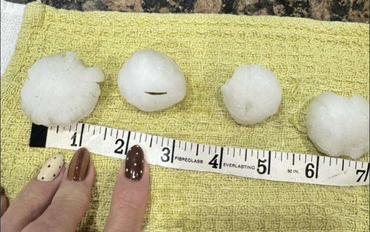
KSL reporters and viewers reported large hail in the area, some of it appearing to be golf ball- and ping-pong-sized, as the alerts also warned. Utah transportation cameras also showed ponding along parts of I-15 where the storm passed through.
The National Weather Service also issued severe thunderstorm warnings across the region Friday afternoon. Some flood advisories, watches and warnings were issued across the Wasatch Front, as well as parts of central and eastern Utah.
The National Weather Service previously advised that there was a marginal risk of severe storms across Utah's northern half on Friday.
A low-pressure system moving toward Utah from the Pacific Northwest is forecast to collide with subtropical moisture moving from the southwest, creating shear that can produce stronger thunderstorms and supercells, Johnson explained. This pattern created some instability on Thursday, including large hail in the Wasatch Back.
"That was the indicator that if nothing changes the next day, we're going to have some pretty juiced atmospheric conditions," he said. "That's exactly what we had."
Storms rarely become strong enough to produce a tornado warning, though. Friday's warning is only the second that the weather service's Salt Lake City office has issued this year. One it issued for Tooele County last month was its first since 2011.
Federal meteorologists ultimately determined that an EF-1 tornado touched down about 3 miles northeast of Dugway last month. Utah averages about two tornadoes every year.
Scattered thunderstorms are possible throughout the evening and will begin to lose strength as the day continues, he said. Some additional showers are possible Saturday morning and afternoon, but cooler and drier conditions are forecast for most of the weekend.
Full seven-day forecasts for areas across Utah are available online at the KSL Weather Center.